
A strong cold front will plunge south through Texas beginning this afternoon into Saturday. The western half of Texas will remain ‘capped’ with no severe weather threat. The same cannot be said for the eastern half of the state. A broken to a nearly solid line of thunderstorms are expected to develop along the cold front this evening. Some of those storms may contain large hail and could produce locally damaging wind gusts up to 70 MPH.
Updated Severe Weather Outlook at Noon
Updated severe weather outlook as of 11:30 AM
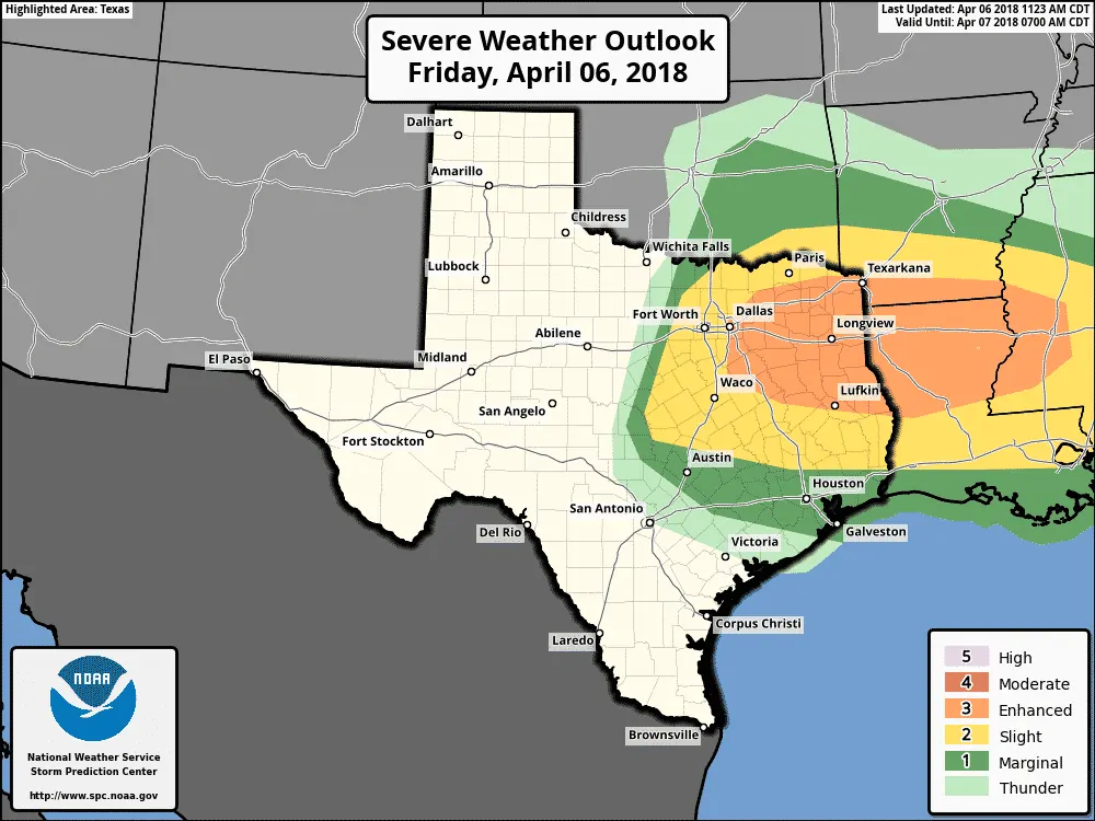
The Storm Prediction Center has expanded the level three risk zone farther west toward eastern sides of the D/FW Metroplex. Those within and near this enhanced risk zone have a thirty percent (30%) chance of severe weather occurring within 25 miles of their location. This enhanced risk zone now includes a majority of East Texas. There is concern that the wind damage threat could become more widespread – hence the enhancement in severe weather probabilities.
A level two risk of severe weather – the standard risk level – is in place for the remainder of North Texas south through Central Texas, the Brazos Valley, and portions of Southeast Texas. Specifically – east of a line from Gainesville to Stephenville to Goldthwaite to Burnet, and north of a line from Georgetown to Conroe to Beaumont. Those regions have a fifteen percent (15%) chance of severe weather occurring within 25 miles of a given point.
Finally – we have a level one risk of severe weather – a marginal risk – just south of the standard risk zone. Austin, Houston, and Galveston are included. Those in this zone have a five percent (5%) chance of severe weather within 25 miles of a given point. Generally speaking, this zone has been issued south of the higher severe weather probabilities to this north. It is anticipated the line of storms will be weakening as they enter this zone late tonight or during the early morning hours Saturday. Storms may still be strong with small hail and gusty winds with isolated wind gusts over 60 MPH.
Storms don’t care where risk lines are drawn on maps. If you are in or close to any of the risk zones – keep an eye out.
Threats
Any isolated storms ahead of the cold front may produce very large hail up to the size of tennis-balls and localized damaging winds around 60 MPH. A brief tornado cannot be ruled out. This conditional risk is highest in Central Texas. A few storms may also develop in East Texas this afternoon with a risk of hail and localized damaging winds.
Our primary severe weather threat will be in the form of a broken to a nearly solid line of thunderstorms along the cold front. The strongest storms within this line may produce localized destructive straight-line winds up to 70-75 MPH, large hail up to the size of a lime (around 2″ in diameter), and short-lived tornadoes within more widespread areas of destructive straight-line winds. Not all storms in the line will be severe.
Timing
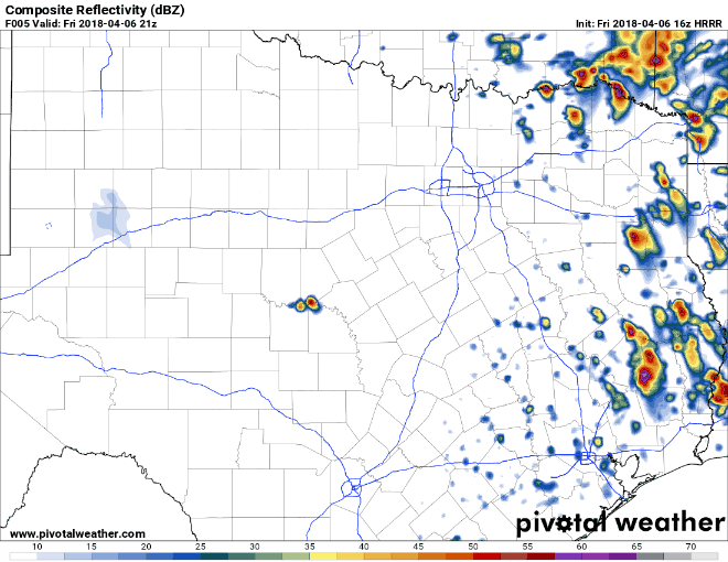
Simulated radar from 11 AM run of the HRRR model. This hour-by-hour animation begins at 4 PM CT this afternoon and runs through 4 AM CT Saturday. This is only a model estimation of what could occur.
These timing aspects are only estimates and could be off by an hour or two. We’ll be using the 11 AM run of the High-Resolution Rapid Refresh for the animation and associated time estimates. These are for the cold front and squall line. Any storms ahead of the squall line, should they develop in Central Texas, could impact locations earlier.
The cold front and a broken line of strong to severe storms may begin impacting the Texas side of the Red River by 4-5 PM from Gainesville east to Texarkana.
- By 7 PM the cold front and line of storms should be near D/FW Airport to Greenville to Mount Pleasant to Jefferson – moving south.
- By 9 PM the line of storms should be south of the D/FW Metroplex. There is some uncertainty on how far west the line of storms will have developed by this time. Some guidance suggests it may extend west of Interstate 35. Regardless, the cold front and line of storms will extend from near Waco to Corsicana to Tyler to near Carthage. Some storms will be severe.
- By 11 PM the cold front/line of storms may be near a line from Georgetown to Madisonville to Lufkin to Hemphill line. Some storms will be strong to severe.
- By 1 AM the cold front and broken line of showers and storms will be near New Braunfels to Brenham to Huntsville to near Jasper. The strongest activity should be near and east of Interstate 45 – with showers and a few storms extending west toward Interstate 35. Some of the storms across Far Southeast Texas may still be strong at this point.


0 Comments