
Six years ago this afternoon I was chasing tornadoes in the D/FW Metroplex. Specifically – the Kennedale tornado near Highway 287 and Interstate 20. At nearly the same time another supercell and tornado were impacting Lancaster. Additional tornadoes would impact places like Forney later that afternoon. I seriously doubt we’ll be seeing a similar scenario play out in Texas today, but we do have the threat of a couple severe storms as a cold front pushes south. Let’s dive into it!
Latest Severe Weather Outlook from the Storm Prediction Center.
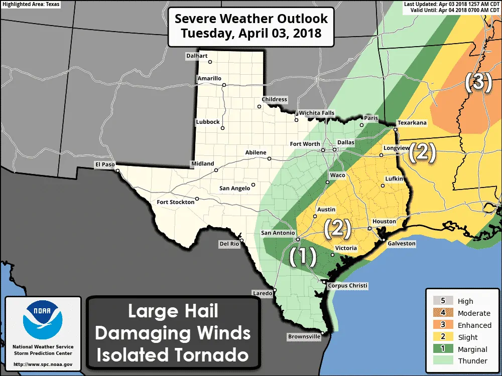
A level two risk of severe weather – the standard risk level – includes much of East Texas, Southeast Texas, the Brazos Valley, and Central Texas. This zone has a 15% chance of severe weather within 25 miles of a given point (your house for example).
A level one risk of severe weather – a marginal risk – includes portions of the Coastal Plains, South-Central Texas, eastern North Texas, and portions of Northeast Texas. This zone has a 5% chance of severe weather within 25 miles of a given point (your house for example).
Severe weather is defined as quarter size hail (1″) or larger, wind gusts of at least 58 MPH, and/or a tornado.
Compared to yesterday the northwestern edges have been trimmed a bit. That trimming is due to the cool front moving a bit faster – and thunderstorms developing farther southeast.
Threats
Some of the thunderstorms that develop along the cold front this afternoon and evening may become severe. Localized straight-line wind gusts of 60 MPH and ping-pong ball size hail would be the most likely threats. The threat of tornadoes would be very low, but not totally zero.
A more conditional risk of pre-frontal thunderstorm activity would also pose a severe weather risk. If these semi-discrete storms initiate this afternoon ahead of the front – the strongest may produce hail larger than the size of golfballs, localized damaging wind gusts of 60 MPH, and pose a low tornado threat.
Timing & Discussion
Thunderstorm development may begin as soon as 2 PM CT along the cold front – and in the open warm sector across Central Texas, the Brazos Valley, and Southeast Texas. I anticipate we’ll have to wait until after 3-4 PM for things to become more active.
As stated in the threat section we may see two ‘waves’ of thunderstorms today. The first wave – conditional on them actually developing – would be semi-discrete storms well south of the cold front. These storms would likely possess supercelluar characteristics with a threat of large hail. They would move northeast.
Meanwhile, thunderstorm coverage along the cold front is expected to increase by the late afternoon across Central Texas into East Texas. These storms would be in close proximity to the southward moving cold front. The strongest of these storms may produce damaging straight-line winds and large hail.
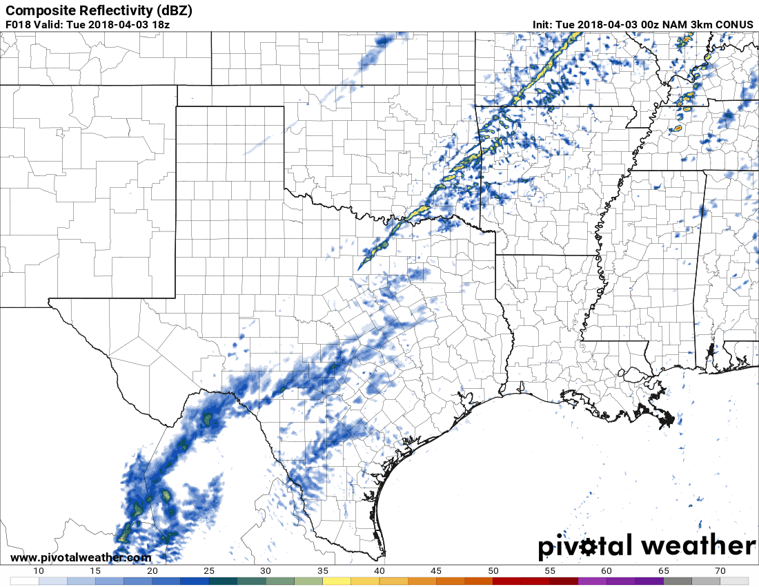
Simulated NAM model radar from 1 PM Today through 4 AM Wednesday. Each frame forward progresses three hours – beginning at 1 PM today and concluding at 4 AM Wednesday. Keep in mind this is only a model projection. Don’t take the exact locations and intensities literally.
Since the eventual squall line’s arrival will depend on the cold front’s speed I hesitate to get too specific. The matter of potential storms ahead of the cold front also complicates the timing aspect.
The cold front and possible line of strong storms should move through…
Austin between 6 PM and 9 PM
San Antonio between 7 PM and 10 PM
Houston between 9 PM and 12 AM
Corpus Christi (although with only scattered showers/storms) around 1 AM on Wednesday
Flash Flood Potential
Thunderstorms will generally be moving at a good clip. The risk of flooding is marginal. We do not anticipate a repeat of last week’s flooding. Minor street flooding is certainly possible after a good downpour.
After Today
Wednesday and Thursday are looking mostly dry across Texas. Southerly winds will return and temperatures will warm right back up to spring averages. Our next storm system will arrive Friday and Saturday with a potentially strong cold front. We’ll deal with that once we get past today’s system.


0 Comments