
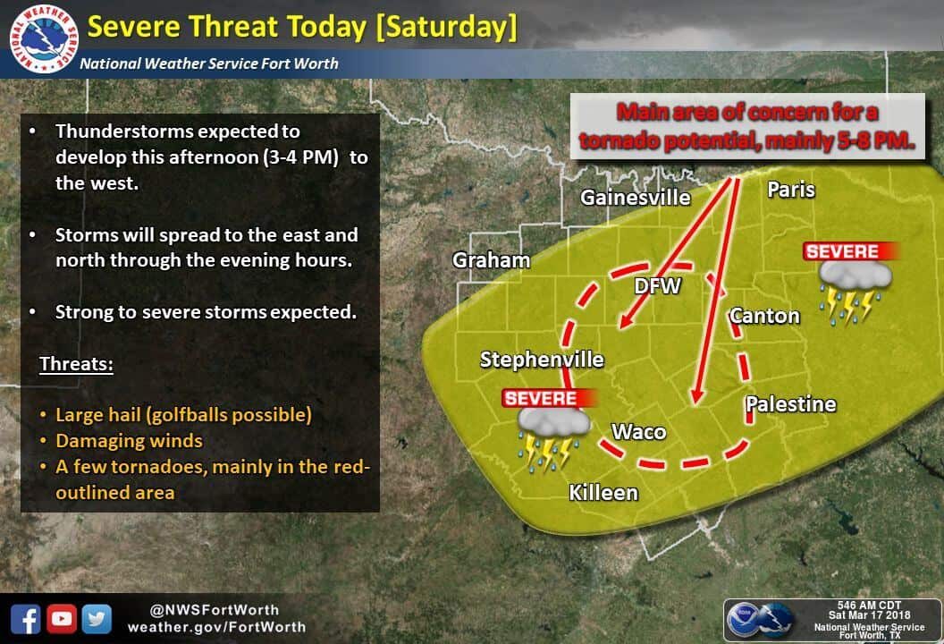
Central Texas and the southern half of north central Texas has been placed in a Slight Risk (level 2) for severe weather this evening. Gulf moisture is quickly advancing north this morning with dewpoints in the mid 60s as far north Corsicana, Waco and Lampasas. We’ll see this moisture continue to advance northward this morning eventually meeting up a cold front that is slowly drifting south across north central Texas. It’s expected that the cold front will stall somewhere near the I-20 corridor by early afternoon, so the threat for strong to severe storms will stay to the south of I-20 this afternoon where the warm and moist air resides. If the front does not move as far south as currently forecast, then we could be dealing with some storms and issues across the southern half of the DFW metroplex this afternoon and evening. We will be watching this and provide updates in additional blogs. The early to mid part of today will remain rain free with no threat for storms. Once we get into the afternoon hours, a surface low is expected to develop out near Abilene with the dryline extending south from the surface low. East of the dryline and south of the cold front, plenty of moisture will be in place with moderate instability levels developing by mid to late-afternoon. As a mid to upper level disturbance arrives by mid-afternoon, we’ll see storms begin to develop southwest of the DFW metroplex between Stephenville and San Saba down into the far northern Hill Country region. Large hail up to the size of golf balls will be the main threat along with damaging winds and frequent lightning. As these storms continue to develop during the late afternoon hours, they’ll move east/northeast towards the I-35 corridor by late afternoon. As they near the I-35 corridor between Hillsboro and Waco, there will be a threat for tornado development given the amount of low level wind shear and instability in place, especially with any storms cells that can remain discrete. We’re not expecting a widespread threat for tornados, but all it takes is one to cause issues. Residents within and near the Slight Risk area will need to keep an eye on the weather later this afternoon and have a way to receive severe weather warnings should any be issued for your particular location.


0 Comments