
Fire weather will be the primary concern in the short-term. A pattern change this weekend into next week will result in stormy and unsettled weather. Beware The Ides of March!
Another high-end fire weather day is forecast today. The Texas Panhandle, West Texas, Permian Basin, Trans-Pecos, and the Davis Mountains are all under threat. Extremely critical fire weather concerns will be in the western two-thirds of the Texas Panhandle. Critical fire weather concerns are expected elsewhere in the aforementioned regions.
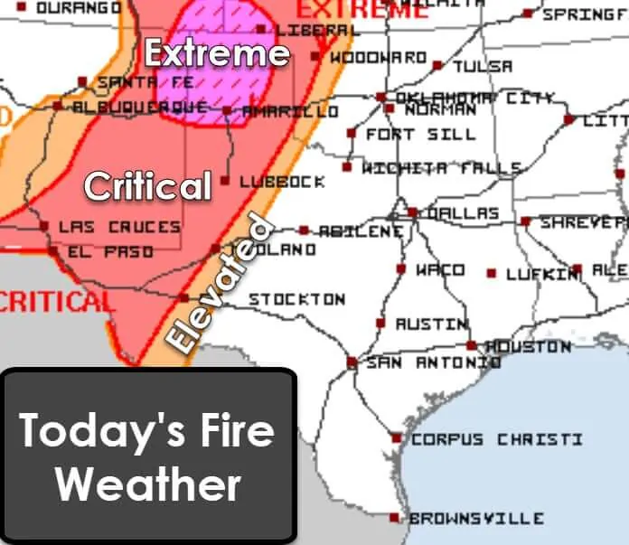
West of a dryline, winds will be out of the west to the southwest this afternoon. Temperatures will soar into the upper 80s to lower 90s. Humidity values will drop below 15 percent. I don’t need to remind anyone that rainfall has been non-existent since last October. Surface fuels are drier than a popcorn fart.
Hold on to your hat!
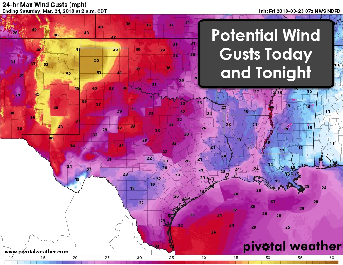
It’ll be windy across all of Texas today. Winds will be out of the south/southeast across the eastern two-thirds of Texas. As previously mentioned, winds will be out of the west to the southwest across the western third of Texas. There is the potential for border-line damaging winds in the Panhandle. Wind gusts may approach 60 MPH there today.
As has been said for the higher-end wildfire risk days…

Any wildfire that develops will have the potential to spread with explosive speed. Those in the risk zones don’t need me to tell them that. Previous fires over the last two months have demonstrated just how quickly spread rates can be. If you have a fire heading your way you should evacuate with haste.
The Texas Forest Service reported yesterday that seven wildland strike-teams are pre-staged to assist local fire departments. Each strike-team has multiple wildland apparatus and crews. Air assets are also available as weather conditions allow. Strong low-level winds and potential wind-shear could create limitations on air resources today.
Did someone say rain?
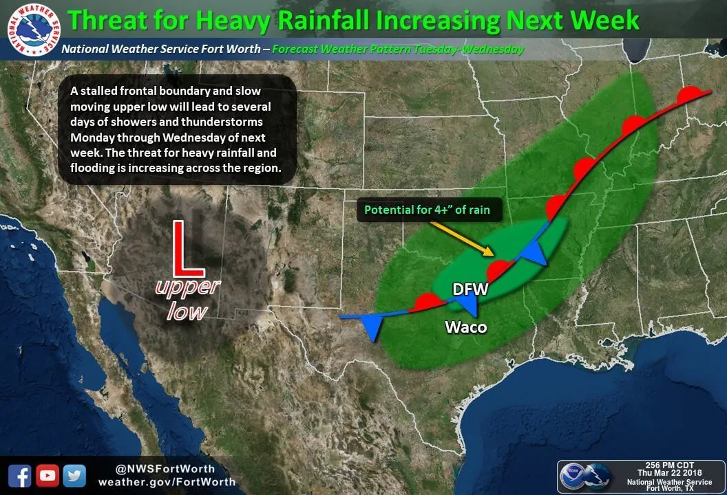
A pattern change will arrive this weekend and take full effect next week. A slow-moving upper level low and a stalled frontal boundary will be two of the primary factors. Strong upper-level lift, an abundance of moisture, and a stalled frontal boundary combined mean a fairly classic heavy rain event. The position of the stalled front will dictate who gets dumped on in the Monday-Wednesday timeframe. Several inches of rainfall will be possible with flooding an increasing threat with time.
Oh Hail No! Yup, severe weather chances return too.
Severe thunderstorms will also be a hazard. We could see isolated severe storms on Sunday in the Big Country and North Texas east of a dryline. The threat for severe weather on Monday may be relatively higher thanks to increased storm coverage along with a dryline.
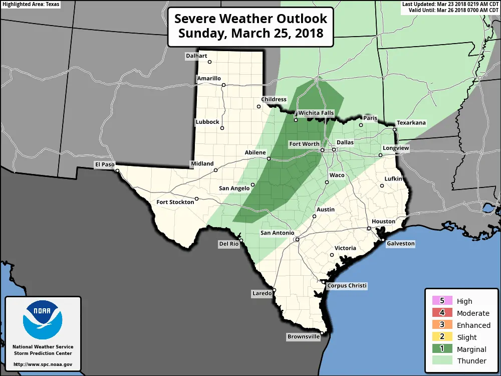
As of now, data suggests that threat will be across the Concho Valley, Big Country, Northwest Texas, and western North Texas. Large hail and damaging wind gusts will be possible with the strongest storms. A tornado threat may exist on Monday. The overall extent and magnitude of any risk can’t be accurately determined at this time range.
We’ll chat more about the severe weather threats in a separate post later today.
We’re approaching the final week of March. We’re entering our typical spring severe weather season. Most systems that bring precipitation chances to Texas will also bring a severe weather threat this time of year. It isn’t unusual, unprecedented, or something to get worried about. Just as California deals with earthquakes, the northeast deals with Nor’Easters, we have to deal with storms.


0 Comments