
There are several hazards to discuss for today and tonight. However, the overall scheme of things is pretty simple. If you live in the southeastern half of Texas you’re going to see more rain today and tonight. Let’s dive into the specifics and get you on the way in your day.
Heavy Rain and Flooding Threat
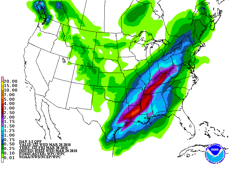
Potential additional rain totals from 6 AM today through the end of the event (Thursday).
The most common issue today will likely be localized flash flooding. South of a slow-moving cool front moisture values are comparable to what we’d see in late May. That is to say any storms out there are producing torrential rainfall rates.
A few locations have received one to two inches of rain in an hour this morning. As thunderstorms move over the same areas that saw heavy rain earlier the threat for flash flooding will increase. Not everyone will experience flooding, but most folks should at least get some rain.
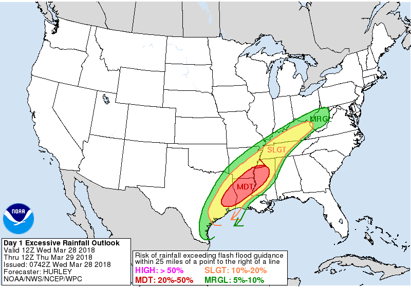
Flash Flood Outlook for Today and Tonight
The highest relative chance of flooding looks to be in Southeast Texas and the piney woods of East Texas today. The Weather Prediction Center has a ‘moderate’ risk of flash flooding there. Localized flooding will be possible across the Coastal Plains into Northeast Texas. Again, not everyone will deal with excessive rainfall.
This is not a repeat of Harvey. We’re not expecting widespread flooding. However – there could certainly be problems where we see 3 to 5 inches of rainfall today. Street flooding will be common and it’ll take a couple inches of rain in a one to two hour period to cause any bigger issues with streams and bayous.
Severe Weather Threat
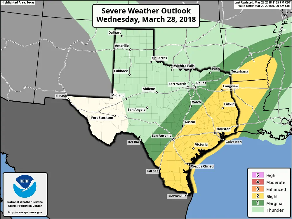
Today’s Severe Weather Outlook
A level two risk of severe weather is in place across East Texas, the Brazos Valley, Southeast Texas, the Coastal Plains, South-Central Texas, the Middle Coast, South Texas, and the Rio Grande Valley. This level two risk means you have a fifteen percent (15%) chance of severe weather within twenty-five miles of your location.
As with storms overnight the primary severe weather threat will be large hail. Some storms may produce hail larger than the size of golf balls. The very large hail threat will depend on how much sun and destabilization we experience. We can’t rule out golfball to baseball size hail with stronger storms in South Texas this afternoon and evening. Localized damaging wind gusts and an isolated tornado cannot be ruled out.
There are a few factors we’ll watch for today in regards to tornado potential. The first will be any boundaries in proximity to the coastline. We may have a corridor of enhanced low-level shear closer to the coast in Southeast Texas west into Coastal Plains and Middle Coast/Coastal Bend. That would result in a slightly higher tornado threat later this morning into the afternoon hours. A second factor will be storm mode. Storms that are linear (line-segments or a squall line) by trait have a lower tornado risk. If we see discrete supercells those would have to be watched closely.
Most of those factors are ones we’ll just have to watch for. Forecasting specific severe weather hazards is more of a ‘nowcast’ versus forecast element in these types of setups. One has to watch surface observations, satellite data, and overall trends. Regardless a severe weather risk is in place. That means one should have a way to receive warnings should they be issued.
General Timing Expectations on Rain/Storm Chances
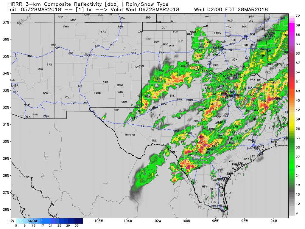
As said previously today will generally be wet across the southeastern half of Texas. The HRRR model shows a line of thunderstorms slowly progressing off to the east from I-35 into East Texas and Southeast Texas. This line of storms will contain heavy rainfall that may induce localized flooding. We note that this line may actually stall out at some point by late morning. Should that occur we may see a ‘zone’ of flooding develop.
South Texas and the Rio Grande Valley may remain dry until the afternoon hours. As the atmosphere destabilizes scattered storms should develop. These storms would move to the east/northeast in an unstable and sheared environment. That means organized thunderstorms (aka severe storms) would be possible. Read above in the severe weather section for more details. Storm chances will continue tonight into Thursday morning across South Texas and the Rio Grande Valley.
The strong storm and heavy rain hazards will both come to an end Thursday morning as a cool front pushes off-shore. Isolated thunderstorms may occur Thursday afternoon in Central Texas, but would be associated with diurnal heating versus kinematic processes. Friday and Saturday are looking good!


0 Comments