
A significant ice storm has caused tree damage and power outages in western North Texas into the Big Country and Northwest Texas. Those in the immediate D/FW Metroplex should be breathing a sigh of relief as it was a close call. The heavy freezing rain and sleet have come to an end for now. Freezing drizzle and spotty light freezing rain remain possible tonight where temperatures are below freezing. Travel conditions are not expected to improve overnight or for the Thursday morning commute.
Another round of freezing rain is possible Thursday morning as another upper-level storm system arrives. This next round of freezing rain is not expected to be as heavy the round today. However, an additional one-tenth to one-quarter inch of ice accumulation may occur. Additional travel issues and tree damage may occur. As this next upper-level storm system arrives we’ll also see warmer air start to advect northward. This warm air advection plus the typical diurnal cycle will cause the freezing line to move north. Those locations that experience freezing rain during the morning hours should switch-over to just rain as temperatures rise just above freezing. Forecasting a shallow arctic airmass is difficult during the best of times, so we’ll have to see just how quickly the warmer air can overcome the sub-freezing airmass. As temperatures rise above freezing we’ll start to see travel conditions improve. Be mindful of melting ice from elevated objects as some fairly significant ice chunks could cause issues when falling.
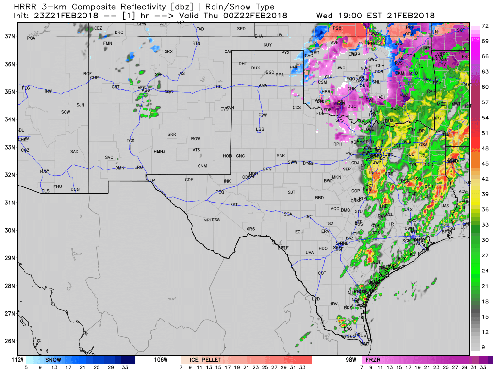
Simulated radar from a high-resolution weather model through Thursday morning. Times are in eastern on the top-right part of the graphic. Green is rain, purple is freezing rain, orange is sleet/freezing rain, and blue is snow. This is not a forecast, just one useful weather model’s idea of what might occur.
Widespread showers and a few thunderstorms are expected by the late morning hours across the Big Country eastward into North Texas and Texoma. Where temperatures are below freezing (west/north of the D/FW Metroplex) freezing precipitation and additional icing is expected. See the previous paragraph for a detailed explanation on the winter-weather aspect. Where temperatures are above freezing it’ll be a cold rain. Small hail may occur with the stronger thunderstorms, but severe weather is not expected.
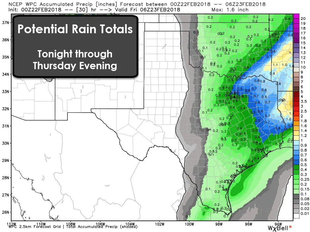
Rain chances will continue off and on across the eastern half of Texas through Saturday. An additional one-quarter to three-quarters of an inch of rain is expected with Thursday’s round of precipitation across the eastern half of Texas. The threat for flooding will be lower, but saturated locations may see the typical low-lying flooding continue.
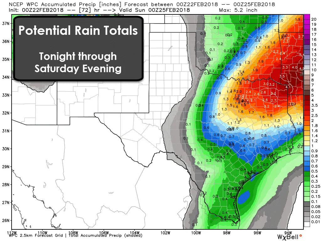
The final upper-level storm system of the week will arrive on Friday and Saturday. This system will once-again bring the potential for showers and thunderstorms to the eastern half of Texas. A threat for a few strong to severe thunderstorms may evolve on Saturday across Northeast Texas as a dryline/cold front move into a more unstable airmass. We’ll deal with any potential severe weather threat once we get a tad closer to Saturday. We’ll also have to watch for any localized flooding potential since soils are saturated. An additional one to three inches of rain will be possible. Locally higher totals are possible across Northeast Texas into Arkansas.


0 Comments