
I hope you enjoyed our one to two days of sunny weather. Our next upper-level storm system is arriving today and won’t push out until tomorrow. All things considered, a ‘two-day’ system is better than what we dealt with last week. The remainder of the work week will stay mostly dry. Just in time for the weekend another storm system may bring additional rain chances.
Severe Weather Potential Today and Tonight
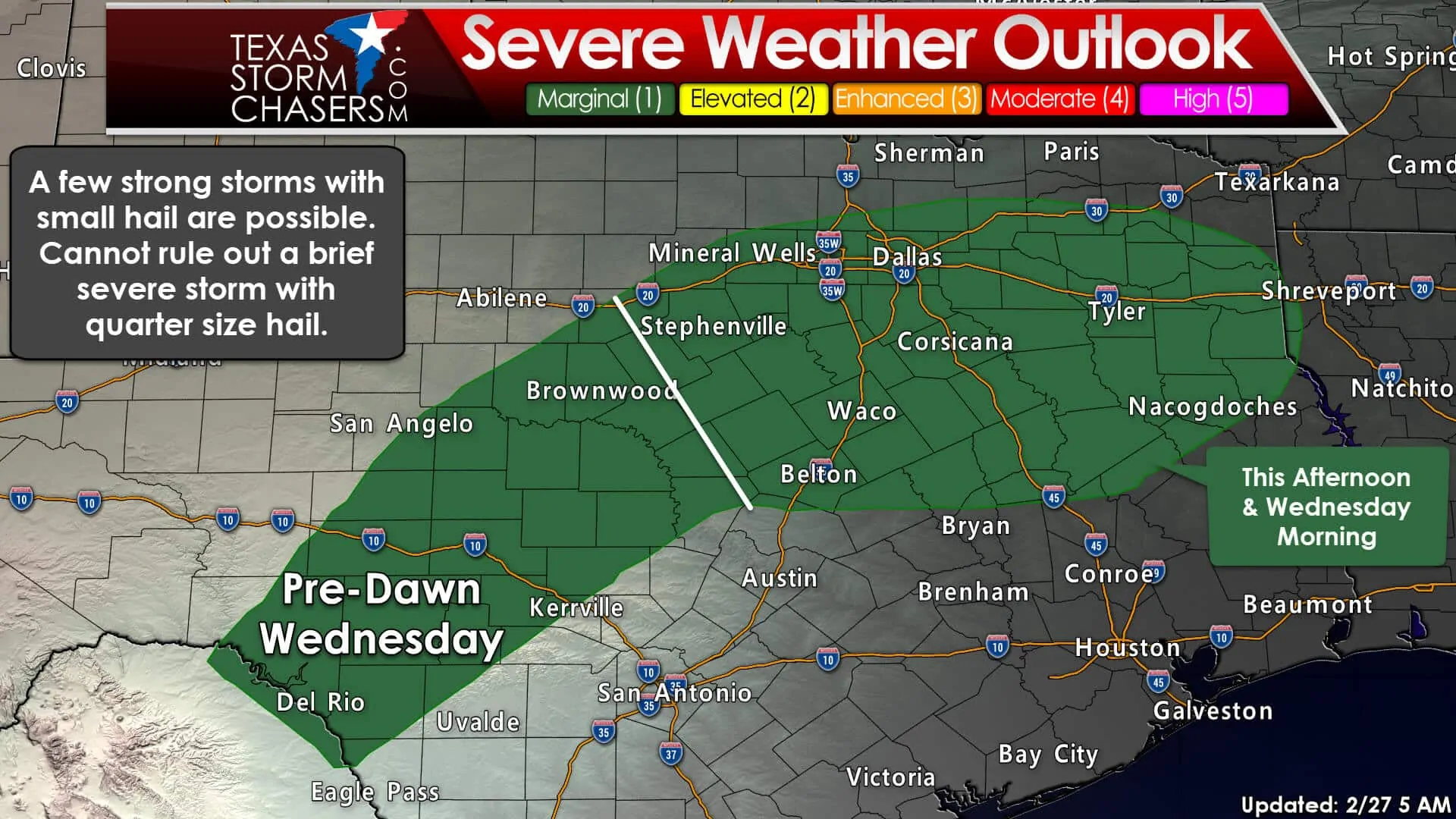
A two-phase time window will be used for the severe weather outlook. The first window is the late morning hours through this afternoon. Scattered showers and thunderstorms will move northeast across North Texas, Northeast Texas, and portions of East Texas. Most storms will not be severe but may produce small hail. One or two storms may briefly become borderline severe with quarter size hail. The surface layer will remain stable. Damaging winds and tornadoes are not anticipated today or tonight. A lull in precipitation may occur this evening.
The second time-window will be after midnight in the pre-dawn hours on Wednesday. Isolated to scattered thunderstorms are expected to develop. They’ll initiate Edwards Plateau into the Concho Valley and western Hill Country. Activity will move northeast. Some of the storms may produce nickel to quarter size hail.
Severe Weather Potential on Wednesday
This is a tricky forecast and one that will see changes in future updates. In order for a severe weather threat to materialize the atmosphere must become unstable. There remains uncertainty on the amount of destabilization that will occur tomorrow. Most weather models are not aggressive in destabilization. Very strong wind shear will be in place, so we’ll need to monitor trends closely. It won’t take too much instability to allow for stronger storms with hail and damaging winds. Too little instability in the presence of very strong wind shear will not allow storms to organize before getting ‘knocked over’ by the strong winds. Expect changes to this aspect of the forecast in coming updates.
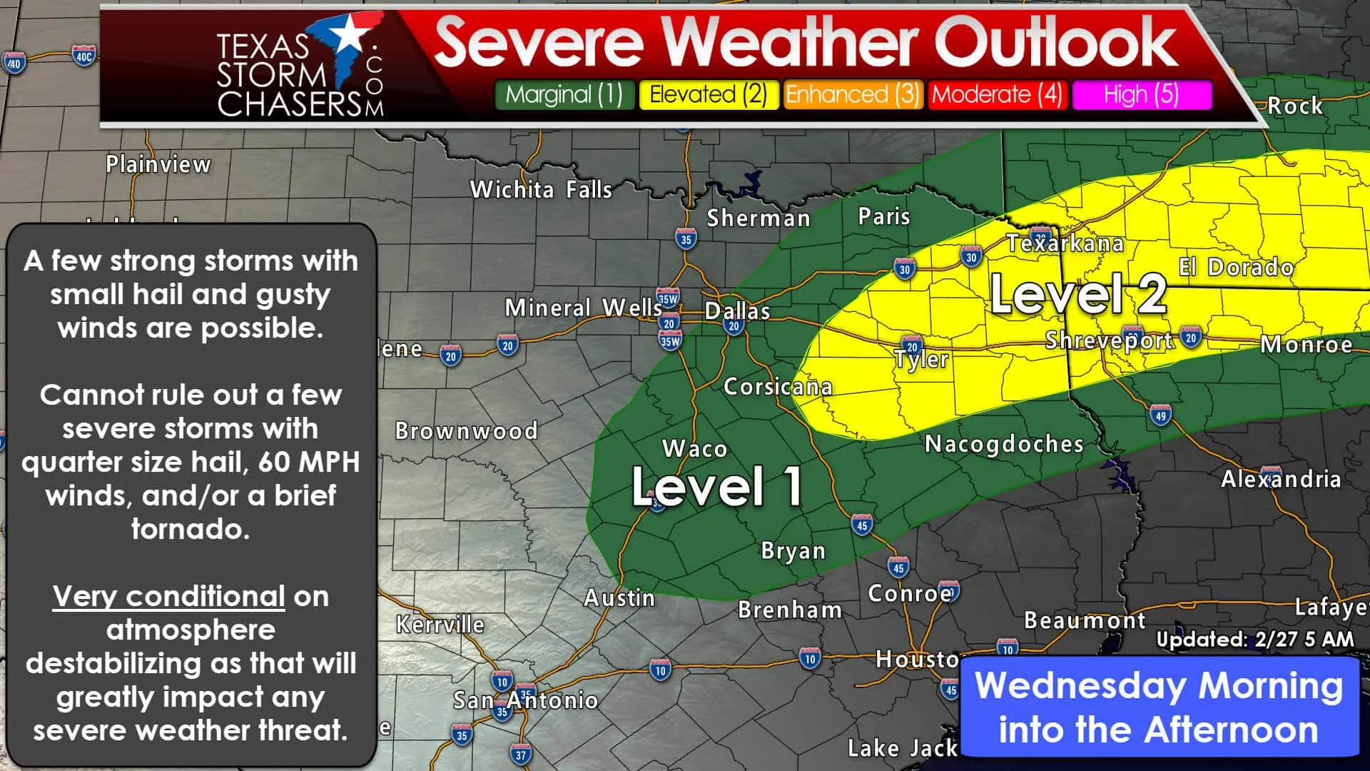
The standard level 2 risk of severe weather has been issued for Northeast Texas tomorrow. A level 1 risk surrounds it including the eastern half of North Texas. Like today/tonight, the primary threat will be brief instances of quarter size hail. I can’t rule out a wind gust up to 65 MPH or a brief tornado, but don’t hang your hat on those threats. If the atmosphere remains fairly stable the severe weather threat may be downgraded in later outlooks. However, any increase in destabilization would result in a higher threat. We’ll see how today plays out and how it may impact tomorrow’s setup. The threat for severe weather would come to an end Wednesday evening as storms move east into Arkansas.
Precipitation Timing
An uptick in precipitation coverage is expected by late morning to early afternoon across North Texas. This will occur in conjunction with the lift from a passing overhead storm system. Activity will move northeast. A fairly rapid uptick in coverage is possible across Northeast Texas and East Texas by early afternoon. Locally heavy rain and new flooding is possible in Northeast Texas. Flash flood guidance indicates about 2 to 3 inches of rain is needed to produce flash flooding. It’ll take less rain for flooding in typical trouble spots.
We may see a brief lull in precipitation tonight. Additional showers and thunderstorms are expected Wednesday morning. They’ll fire up in the Edwards Plateau to Concho Valley to the western Hill Country. That activity will move northeast into North Texas, Central Texas, and eventually Northeast Texas and East Texas on Wednesday. Locally heavy rainfall and some new flooding may occur. After this second round, the forecast becomes murky. Dependent on if the atmosphere can recover and destabilize tt’s possible we may see additional activity develop Wednesday afternoon/evening back in North Texas. We’ll just have to wait and see how the event plays out today.
Possible Rainfall Accumulations
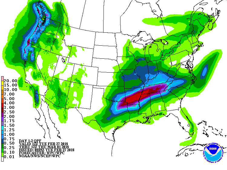
Potential rain amounts through Wednesday Night
One-half to one and a half inches of rain may fall in North Texas through Wednesday Night. One to three inches of rain with locally higher amounts are possible in Northeast Texas. A tenth to one-half inch of rain may fall in Central Texas. A trace to a one-quarter inch of rain is possible in Southeast Texas and in the Edwards Plateau. Nothing for the Texas Panhandle, West Texas, Permian Basin, or South Texas I’m afraid.
Localized flash flooding is possible in Northeast Texas. New rises on creeks, rivers, and lakes may occur.


0 Comments