
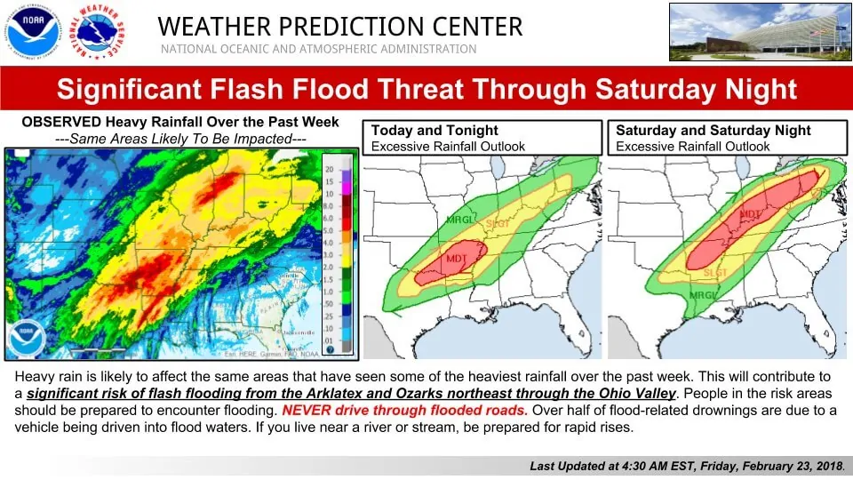
With the threat of winter weather now concluded we’re now going to have to face the dual threat of additional flooding and potentially severe thunderstorms. Flash flood warnings are in effect for several counties in East Texas. With moisture levels in the atmosphere comparable to what we’d see in May rainfall rates have been quite efficient. This morning’s activity should slowly move northeast through the morning hours. Our current upper-level storm system will be departing this afternoon. Our next system will arrive late tonight and into the day Saturday. We should see a temporary break from the heavier, widespread rains this afternoon. Scattered light showers, mist, and fog will not make it pleasant out there.
More heavy rain and flooding woes…
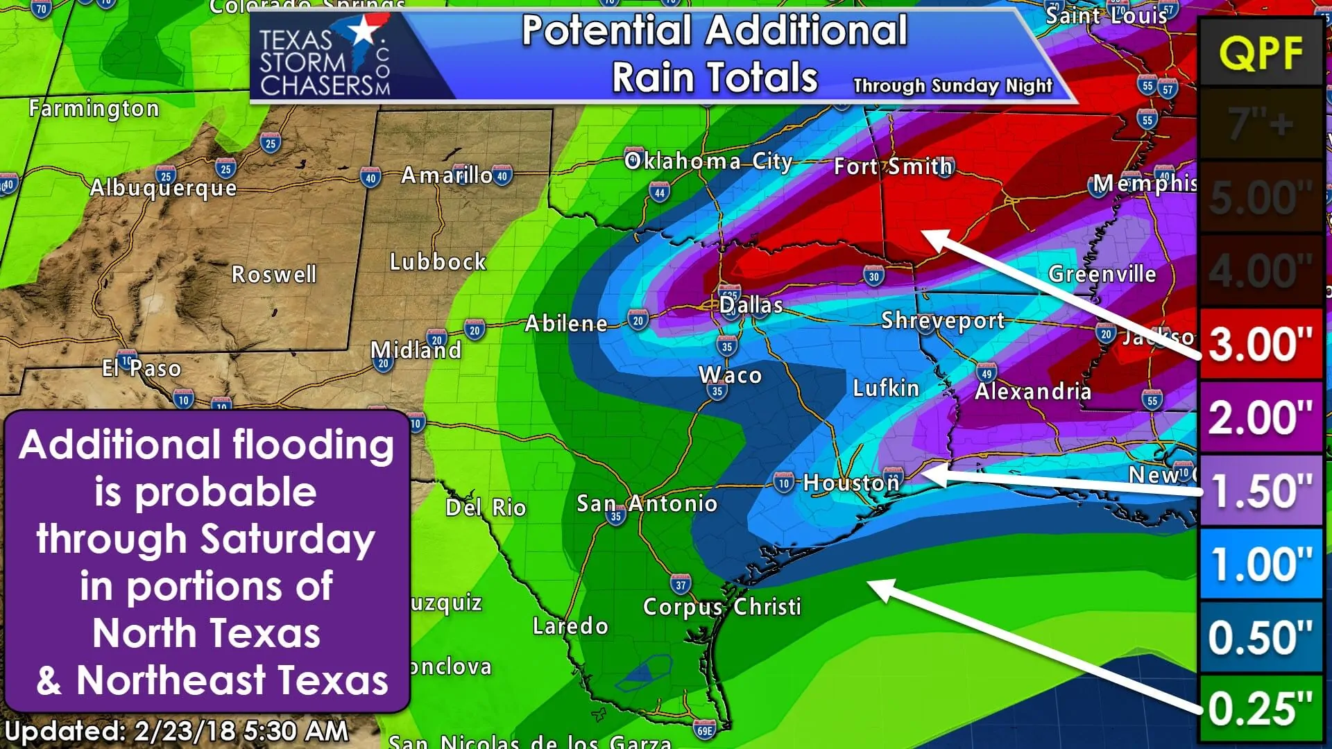
The Weather Prediction Center’s precipitation forecast, beginning at 6 AM, has the highest rainfall accumulations across North Texas and Northeast Texas through the weekend. That forecast lines up well with what’s going on this morning. Our next system tomorrow will bring a line of thunderstorms that will move from west to east across North Texas, Northeast Texas, and East Texas. Rain chances will shift into Southeast Texas on Sunday where a secondary maximum of one to two inches of rain will be possible. Saturated soils in North Texas and Northeast Texas mean any additional precipitation will contribute to the threat of flooding. A lull in the heavier rain this afternoon will bring a short-term break, but additional heavy rainfall is expected tonight into Saturday.
Severe Weather Threat Tonight
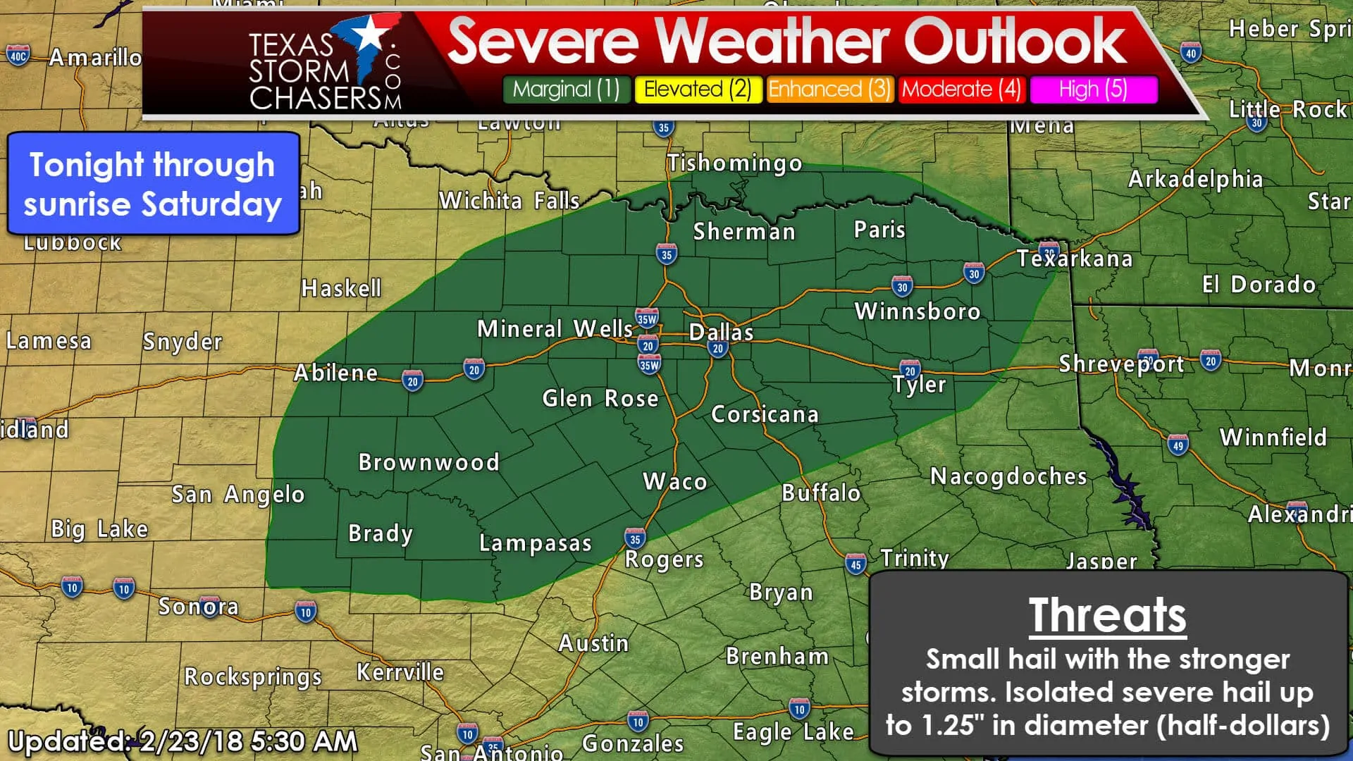
Winter weather is outta here and now we’ve got to deal with the threat of stronger thunderstorms. A marginal severe weather threat may develop after midnight into the pre-dawn hours Saturday across eastern sections of the Concho Valley, Big Country, eastward into all of North Texas and Northeast Texas. Mid-level instability values will be on the rise with the approach of our next storm system. Like yesterday – even where surface temperatures were quite cold – we’ll probably see some stronger thunderstorms with hail.
Temperatures aloft will be cooling, so it won’t take much to get small hail to be generated. A majority of storms that do produce hail shouldn’t see hail sizes reach severe limits – generally pea to dime size. We can’t rule out a few hailstones reaching the size of quarters to half-dollars. Heavy rainfall will also create a flooding concern, espucially in areas where we’ve already seen 2-5+ inches of rain.
Increasing severe weather threat on Saturday
Late Saturday morning through the late afternoon hours on Saturday has the potential of being active. An area of low pressure at the surface will be in western Missouri by early Saturday afternoon. At the surface winds to the south of the surface low will be blowing out of the south/southeast. Winds in the lower-levels of the atmosphere will be out of the south before veering to the southwest as you increase in altitude. Increasing in height to around 5,000 feet above sea level winds could be out of the southwest at about 50 to 60 MPH. By the time you get up to 18,000 feet ASL winds will be screaming at over 100 MPH.
That change in wind direction with height along with the increase in wind speeds with height are both considered to be strong wind shear (technically directional shear and speed shear). Dewpoint values ahead of a surface dryline (I guess you consider it a weak cool front) will rise into the middle to upper 60s – quite moist. Instability values won’t be particularly impressive, but certainly high enough when combined with the very strong wind shear in place. With the weak front acting as a source of lift I expect we’ll see thunderstorms erupt.
Storm Prediction Center Outlook for Saturday
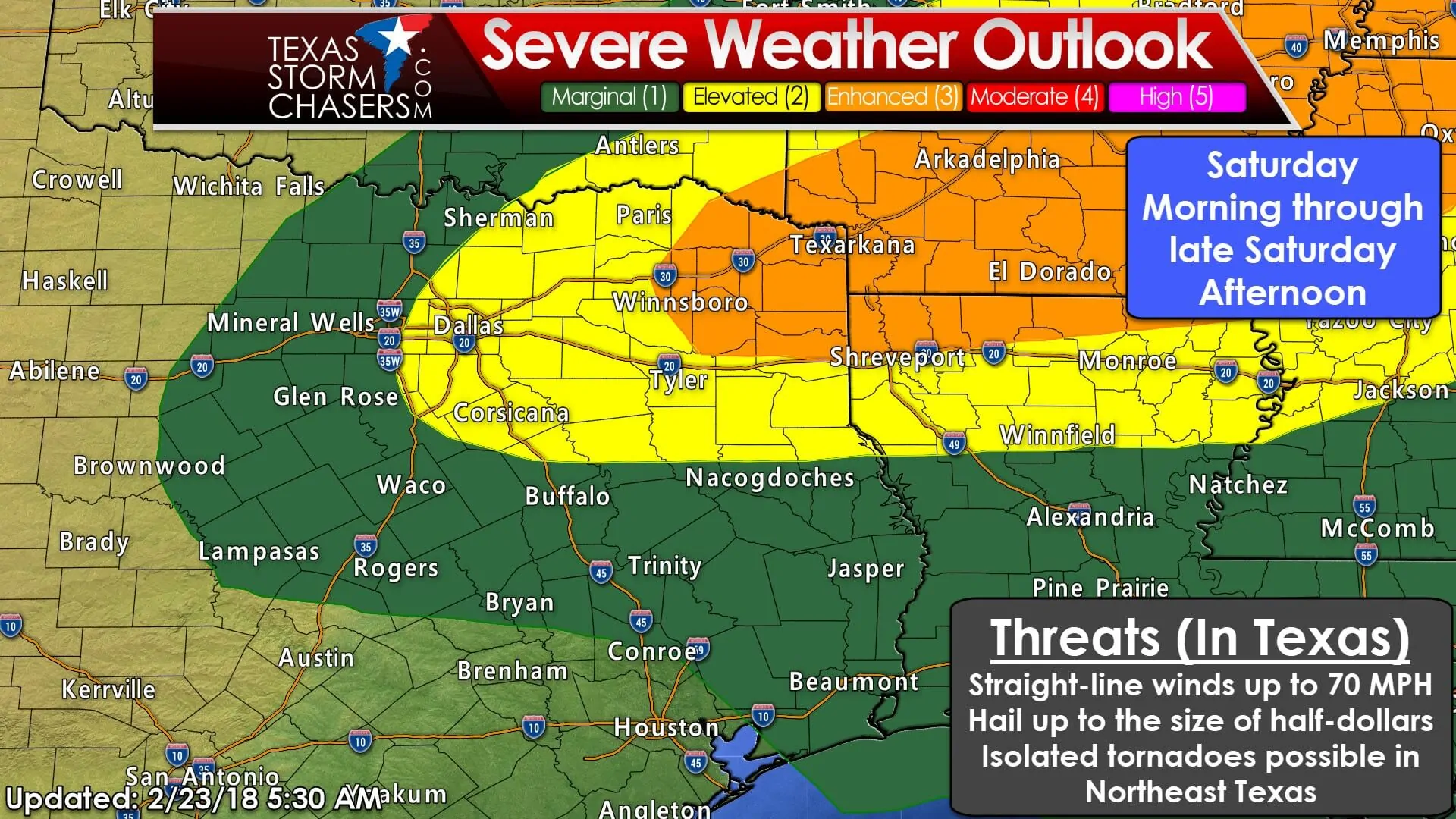
An enhanced risk of severe weather – level 3 out of 5 – has been issued for far Northeast Texas for Saturday. That enhanced risk runs east of a Clarksville to Winnsboro to Gladewater to Marshall line. An ‘enhanced’ risk means a 30% chance of experiencing severe weather within 25 miles of a given point (your house for example).
The standard level 2 risk (yellow) runs east of a Sherman to Arlington to Hillsboro to Palestine to Center line. Those in that risk have a 15% chance of experiencing severe weather within 25 miles of a given point (say your house, your work, etc). Finally, we’ve got a marginal level 1 risk that includes the remainder of North Texas south into Central Texas, east into the Brazos Valley, and through the Piney Woods of East Texas and far Southeast Texas. The marginal risk zone means a 5% chance of severe weather within 25 miles of a given point.
Timing looks to be late morning through the late afternoon hours, although stronger storms with some hail may be ongoing earlier in the morning (see the previous paragraph). This outlook will be updated this afternoon and thunderstorms don’t read maps. Don’t get hung up on exactly where the lines are located. If you’re in or near any risk, you’re close enough to want to pay attention.
Storm timing on Saturday

The primary and most common severe weather threat on Saturday will likely be straight-line winds up to 70 MPH and the potential for large hail. There will be the risk for an isolated tornado as well. The highest (relative) potential for a tornado will be in the enhanced risk across Northeast Texas. The surface low will be fairly far our north/northeast. The higher threat for tornadoes seems to be across Arkansas into western Tennessee.
That said, it only takes one tornado to cause big problems. Not to mention we’re still a day out and small-scale features have yet to become apparent. Tomorrow’s setup favors a linear mode. A linaer mode (squall line) has a lower tornado threat, but an increased straight-line wind risk. Brief tornadoes are possible in the squall line itself. Any discrete thunderstorms ahead of the squall line would have an increased tornado threat, so we’ll be watching for those. Dime to quarter size hail can also be expected in stronger cores.
By early evening the strongest thunderstorms should be in Arkansas as the surface low moves farther to the northeast. The ‘cool front’ and line of storms will start to outrun the area of upper-level lift. We should see a decrease in thunderstorm intensity as the line of storms moves toward Southeast Texas. Locally heavy rainfall will become the primary hazard. Strong storms will remain possible with gusty winds and small hail. After this weekend’s storm system we’ll have a few days of quieter weather, at least until mid-week.


0 Comments