
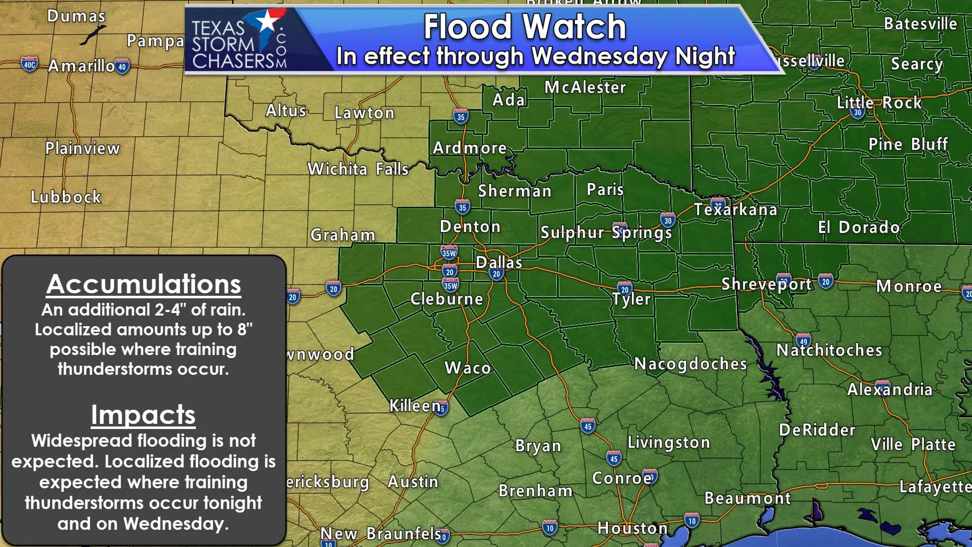
A lot to talk about in this evening’s blog update, so we’ll get right down to it. The main threat for the next 24-48 hours will be the threat of additional heavy rain and flooding across parts of north, east and central Texas. Flash Flood Watches remain in effect through Wednesday night across the area with an additional 2-4 inches of rainfall expected with higher localized amounts wherever the heavier bands of rain set up. Some of our short-range model forecasts are generating rainfall totals in excess of 8-10 inches across portions of northeast Texas, and while that may not actually materialize, it’s significant for this time of the year. As always, remember that flash flooding can occur quickly and without much warning (hence the term “flash” flooding), so avoid low water crossings known to be problematic during these events if at all possible. If roads have been blocked off, do not drive past the barricades! They are there for a reason!
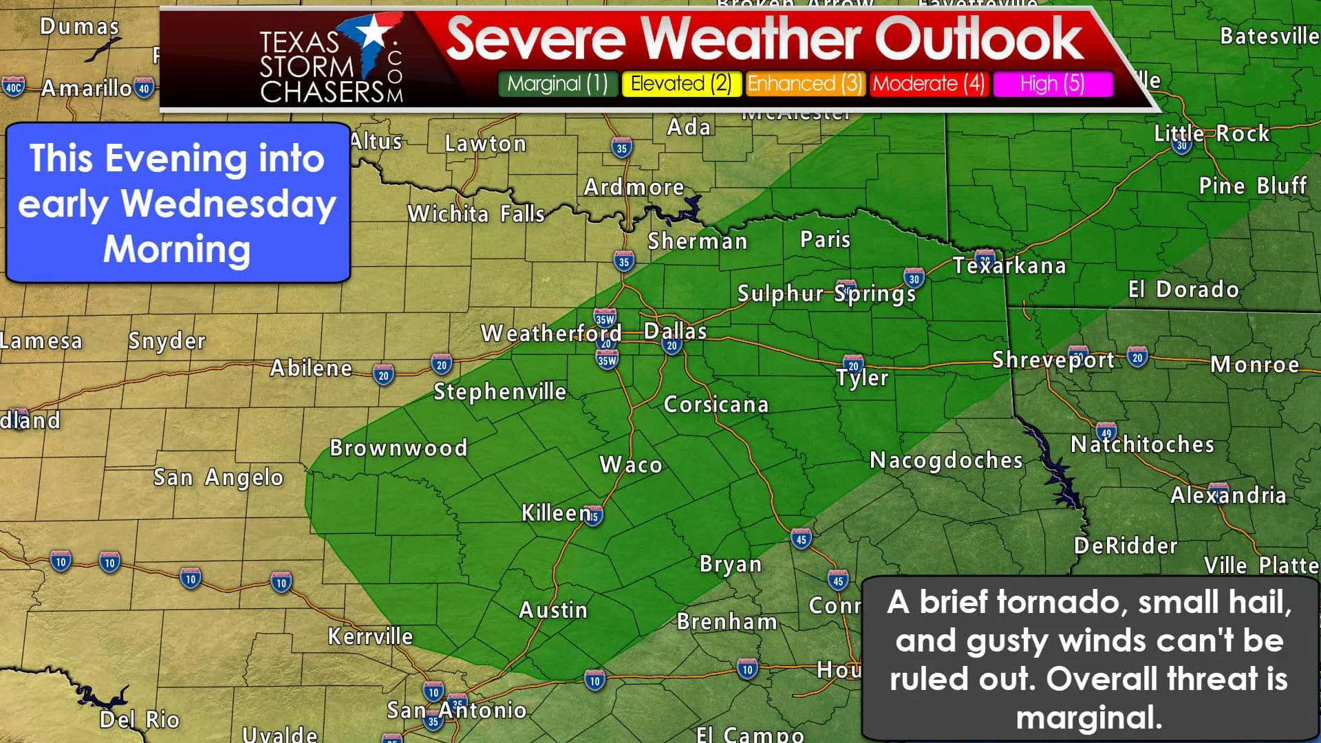
The threat for isolated severe storms remains for portions of central and eastern Texas for areas along and ahead of the cold front which is slowly making it’s way south across north Texas at the moment. For storms behind the front, expect periods of heavy rainfall, frequent lightning and some small hail. For storms out ahead of the front, damaging winds and hail will be the main threats through the evening and overnight hours. There is also a small risk for a couple of weak tornadoes this evening and into the early overnight hours across central Texas…mainly for areas along and within about 60 miles east and west of the I-35 corridor between Dallas and Austin. This threat should wane a bit once we lose daytime heating, but as the front continues to glide south and interact with the very moist airmass out ahead of it, we will still have sufficient instability and low level wind shear to keep the threat for a quick tornado spin-up during the overnight hours. Again, the threat is small, but non-zero, so be sure to have a way to receive weather warnings as you head to bed this evening.
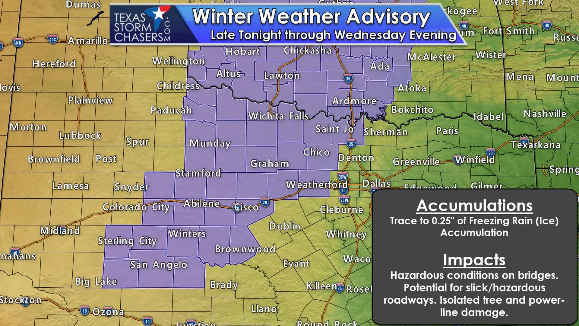
In addition to the heavy rainfall, flooding and severe weather threats, we also have a threat for Wintry Weather…mainly in the form of freezing rain. Winter Weather Advisories have been issued for the counties north and northwest of DFW along the Red River, and for numerous counties west and southwest of the immediate DFW metro all the way down into the Big Country/Concho Valley region of west central Texas. The Advisory does NOT include the immediate DFW area. The current Winter Weather Advisories my be extended further west to include portions of the southern panhandle and rolling plains, but that determination will not be made until later tonight or early tomorrow based on current trends. Temps behind the front overnight into tomorrow expected to range from the mid-20s, low 30s across the regions under the Winter Weather Advisories while periods of light precipitation continues to fall. This will generate periods of freezing rain across these regions overnight and through tomorrow evening. Ice accumulations around 1/10th of an inch will create dangerous driving conditions especially across bridges and elevated roadways by tomorrow morning and through the day Wednesday. Sidewalks and stairwells may also become slick and hazardous for pedestrian traffic. Be sure to check your local media outlets for the latest on local driving conditions, and potential school and business closures and delays before you head out tomorrow morning.
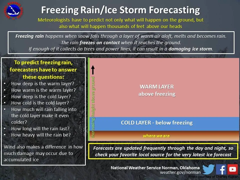
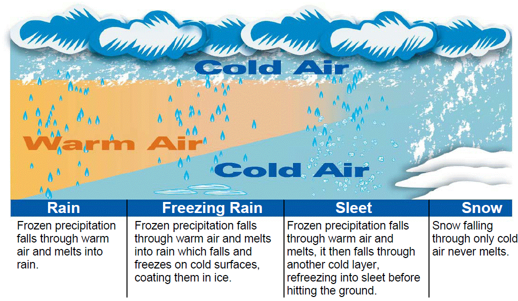
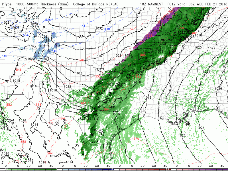
Here’s a look at a simulated radar loop from one of the latest short-range model. Keep in mind this is not live radar…it’s just one model forecast depicting how the radar may shape up between now and midnight tomorrow, but it will give you a pretty generalized idea of how things may shape up overnight and through tomorrow. The pink and purple areas depict areas where freezing rain is expected to fall. How do forecasters know the precipitation will fall as freezing rain versus sleet or snow? It’s based on how deep the layer of subfreezing air is behind the cold front. As you probably remember from science classes back in the day, cold air sinks because it is more dense than warm air. So, as these cold fronts arrive, most of the cold air digs up under the warm air and stays closer to the surface. In our case overnight and tomorrow, precipitation aloft in the form of snow will be falling through a rather deep layer of warm air and melt, then through a rather shallow layer of cold subfreezing air before it arrives at the surface and re-freezes.


0 Comments