
I want to start out with a part of the National Weather Service Houston’s afternoon forecast discussion. Lead meteorologist Scott Overpeck stated “This is probably one of my top 5 toughest most challenging forecasts to make and one of the toughest forecast decisions to make. Big thanks to our forecast team collaborating on this but 12Z models all show very similar trends.” Forecasting winter weather in Texas is difficult and very small changes in a number of parameters can make or break a forecast. Obviously, when forecasting the potential for a significant winter storm those factors are even more important. Plans are changed, businesses close, and the daily routine is interrupted – all based off something that hasn’t even happened yet. Remember that every winter event in Texas will have a surprise or two, but all we can do is provide the best ‘forecast’ we can be based on data, experience, and collaboration. Let’s get down to it.
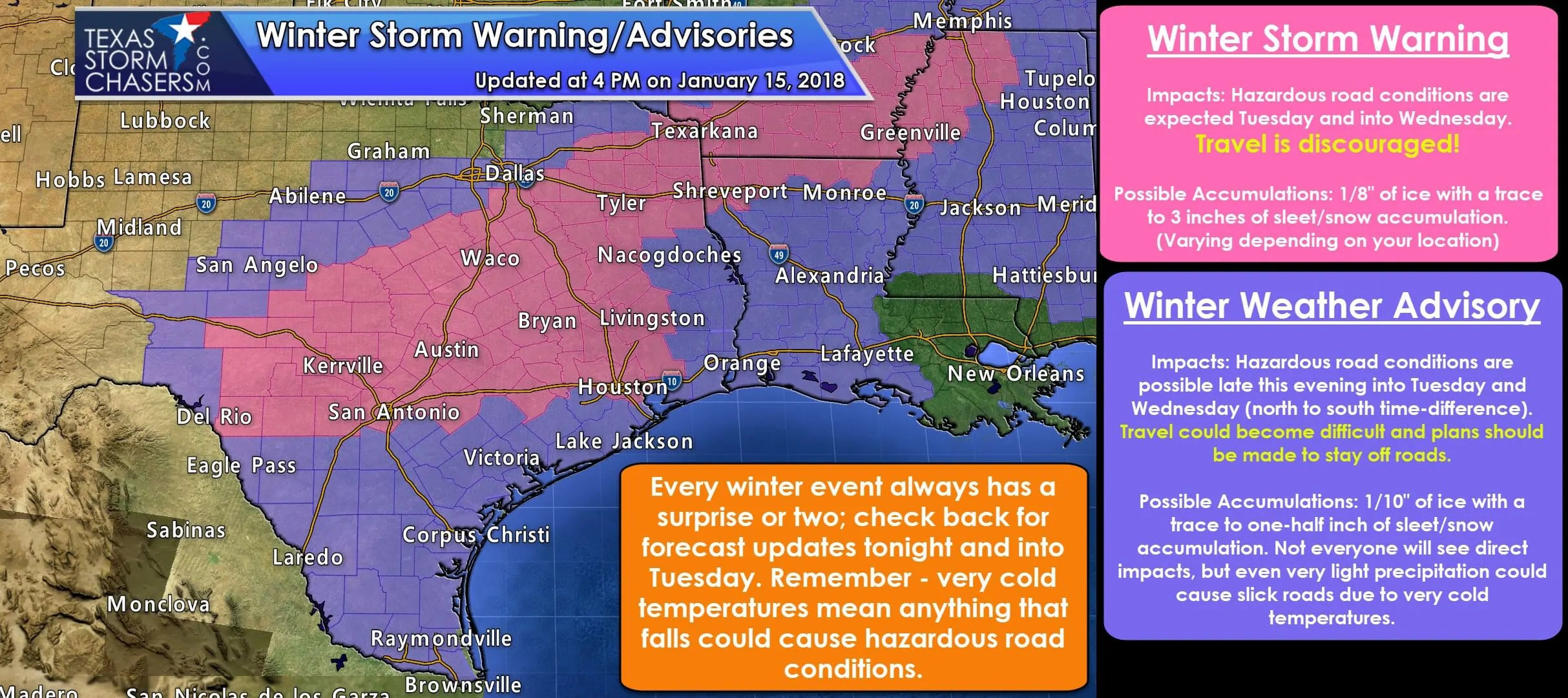
Winter Storm Warning is in effect on Tuesday for portions of the Hill Country, Central Texas, Brazos Valley, Southeast Texas, Northeast Texas, and portions of East Texas.
A few towns included: Uvalde, Rocksprings, Sonora, Junction, Brady, San Saba, Kerrville, San Antonio, New Braunfels, Kyle, Austin, Georgetown, Killeen, Gatesville, Hamilton, Waco, Hillsboro, Waxahachie, Corsicana, Terrell, Mineola, Tyler, Longview, Mount Pleasant, Texarkana, Carthage, Palestine, Buffalo, Crockett, Madisonville, Bryan, College Station, Huntsville, Livingston, Conroe, Brenham, La Grange, Sealy, Katy, Houston, and Liberty.
Impacts: Hazardous travel conditions are expected to develop from north to south beginning later this evening and into the day Tuesday. Once rain changes over to freezing rain/sleet/snow, we may see road conditions go downhill quickly, or it may take some time. Regardless surface temperatures will fall into the 20s and accumulations will begin on roads. Dangerous travel conditions are expected and I encourage you to stay home if you can tomorrow. This includes the Austin, San Antonio, and Houston metropolitan areas. The morning commute may be okay, but conditions will be dicey by the afternoon and evening drive home.
Winter Weather/Travel Advisory is in effect on Tuesday for the Rio Grande Valley, South Texas, the Middle Texas Coast, the Coastal Bend, far Southeast Texas, East Texas, portions of North Texas, portions of the Big Country, and portions of the Concho Valley. In terms of the D/FW Metroplex: Those to the south and east have a higher chance of receiving accumulations. Those from Denton and McKinney north may not receive any accumulations.
Impacts: Light winter precipitation could deposit a thin layer of ice on exposed objects. With temperatures falling well below freezing from north to south any precipitation that does fall, even if it is very light, could cause bridges and elevated roadways to ice up. Some surface roads may become slick and hazardous as well. Any road impacts that develop may not improve until Wednesday.
Accumulations: Not everyone will see accumulations or impacts in the advisory zone. Accumulations are expected to be light with the potential of a few hundreds of an inch of freezing rain (with 0.01″ of freezing rain enough to ice up bridges/roads – similar to events we’ve seen over the last few weeks). Up to a one-half inch of sleet/snow accumulation possible in some spots. A trace of sleet/snow accumulations possible in South Texas and the Rio Grande Valley late Tuesday into the morning hours Wednesday.
I really don’t want to post too many weather model graphics during this event. We’re not expecting a widespread, heavy sleet or snowstorm. Most precipitation is going to be light. The concern is that temperatures falling into the 20s will allow even light precipitation to accumulate on roads – something we don’t see as often with temperatures usually in the low 30s during our events. That’s why this storm is expected to be one with high-impacts, even though accumulations are not expected to be overly impressive. It only takes a trace of freezing rain or a dusting of sleet/snow – a five-minute burst for example – to turn roads into skating rinks. You can drive on snow if you know how, but driving on ice is nasty no matter your level of driving experience.
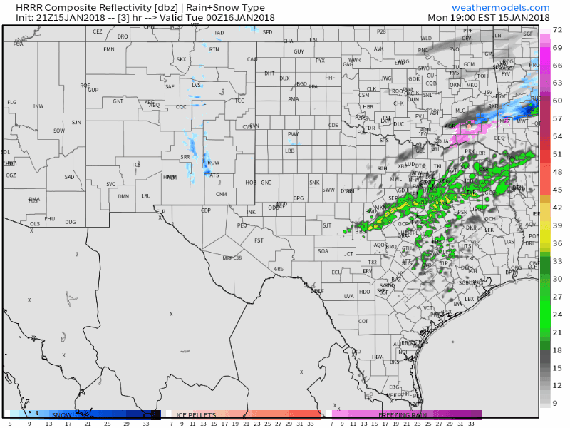
One model image I will share is from the High-Resolution Rapid Refresh (HRRR). It’s simulated radar image depicts the overall transition from rain to winter precipitation fairly well tonight. One change to the forecast compared to earlier is that colder air may be moving a tad faster than earlier thought. That would allow for a faster change-over, slightly increased accumulations, and more importantly – an earlier start time to potential impacts. Times are in the top-right part of the graphic and are in Eastern – so subtract an hour. This is just one model and it probably isn’t completely right. For example: It may be overdoing the precipitation coverage/intensity.
These graphics are from local National Weather Service offices. They convey more detailed accumulation and timing aspects to the forecast. You can go to www.weather.gov and plop in your city/zip code for specific weather information.
We’ll probably have a mid-evening blog update, but otherwise our next ‘detailed’ update will probably be around 11 PM.


0 Comments