
Precipitation has come to an end across most of North Texas as drier air filters in from the north. Most of the D/FW Metroplex came by unscathed which matched up with the forecast fairly well (highest impacts south of Interstate 20). As usual, every winter weather event will have a surprise or two. One surprise was the drier air filtering in a tad more quickly into southern sections of North Texas, mainly keeping Waco to Temple drier than expected. You don’t have to look far to find impacts, however with Navarro County and now Austin experiencing dangerous road conditions.
Widespread travel problems are being reported in the Austin and San Antonio metros. Freezing rain and sleet continues with surface temperatures now falling into the middle 20s. Not only are most bridges now iced over, but we’ll start to see surface roads become hazardous as well. Travel is discouraged in the Austin and San Antonio metros east through the Brazos Valley into Southeast Texas – north of Interstate 10. Temperatures will not rise above freezing until late Wednesday morning.
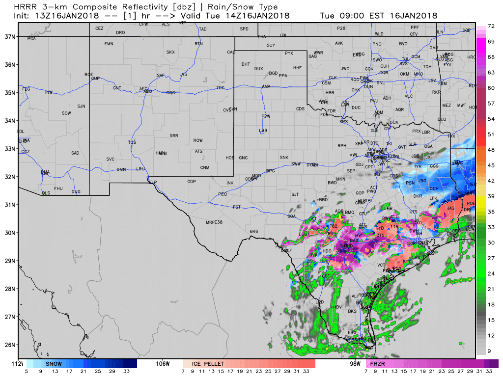
13Z HRRR: Simulated model radar through tonight. Times on top-right part of graphic are in Eastern, so subtract an hour.
Periods of freezing rain and sleet will continue to impact portions of Central and South-Central Texas this morning. We should see precipitation start to come to an end around noon in Austin and by 2 to 3 PM in San Antonio.
The winter storm is just beginning in Southeast Texas. Temperatures are now falling below freezing in the Houston metro. Icy bridges are being reported just north and west of Houston, and these conditions will likely continue to deteriorate and spread into most of Houston proper through the late morning hours. The freezing rain and sleet near San Antonio is moving east and will impact Houston around 10-11 AM as sleet and or a sleet/snow mix. Expect most bridges to ice over and even some surface roads to become hazardous. Travel is discouraged across Southeast Texas as conditions will become difficult by late morning into the afternoon hours. A treacherous evening commute is anticipated. Temperatures will not rise above freezing until late Wednesday morning.
A complete changeover to snow is possible in Houston before precipitation comes to an end around 5-7 PM from north to south.
Freezing rain is expected to cause hazardous travel conditions in the Coastal Plains – between Houston and Corpus Christi – later this morning and through the afternoon hours. Some sleet may mix in. Corpus Christi may be impacted before precipitation ends early this evening. The combination of freezing rain/sleet and temperatures falling into the 20s will create dangerous road conditions and travel is discouraged this afternoon and evening.
Temperatures are at or will be below freezing in far Southeast Texas shortly. Beaumont to Lake Charles will start having travel issues by the early afternoon as sleet moves in from the west. Like farther west in Southeast Texas, we’ll start off with bridges icing over first, but could see surface roads become slick. A changeover to light snow is possible before precipitation ends around 6 PM.
A brief period of freezing rain may occur in Deep South Texas and the Rio Grande Valley this evening. Precipitation will be coming to an end as temperatures fall below freezing, so widespread impacts don’t look as likely compared to the farther north. However – it would be wise to treat bridges as if they had icy patches once we get into the evening hours. We should see precipitation moving off-shore by 10-11 PM. That will bring a conclusion to this winter storm in Texas.
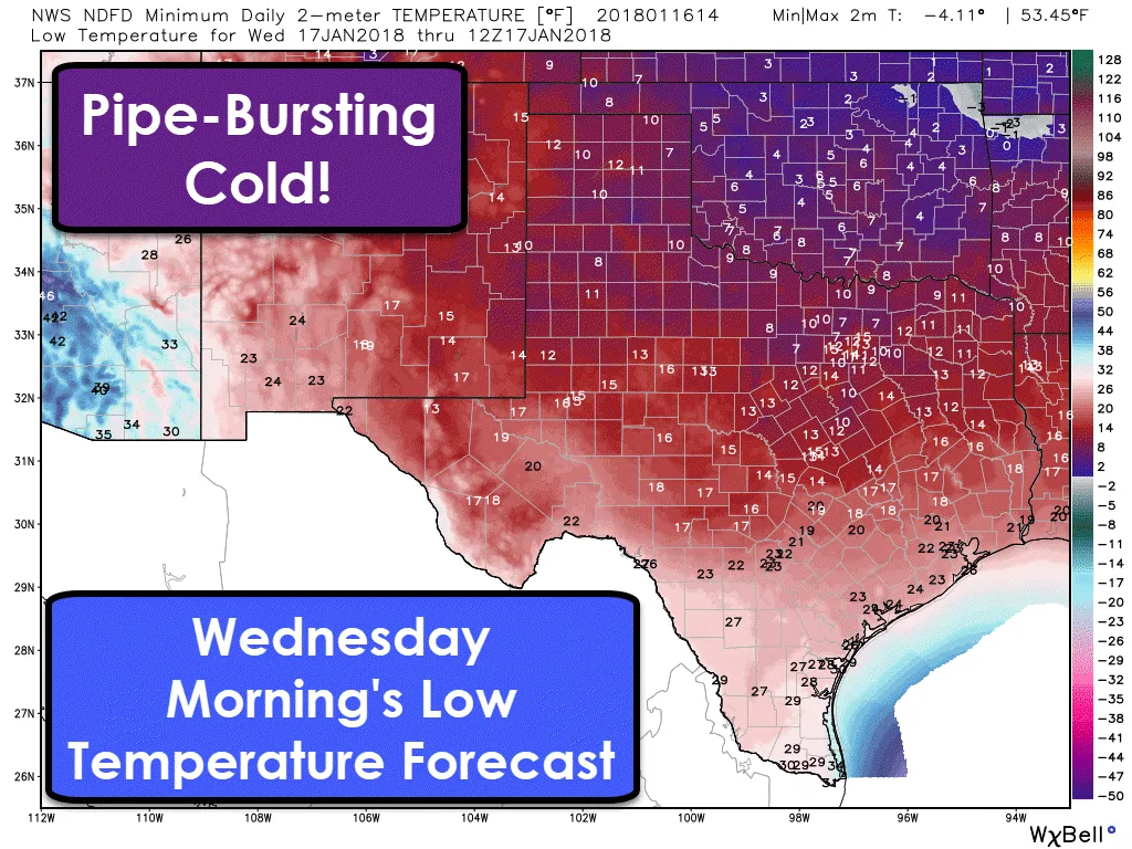
An arctic high-pressure will be nearby tonight. With clearing skies, we’re going to see temperatures drop like a rock. Tonight’s are now forecast to be in the single digits as far south as the D/FW Metroplex and western North Texas. A hard freeze is expected across the entire state except in Brownsville and a two-county area immediately along the coast in the Rio Grande Valley.


0 Comments