
Temperatures over the last month may not have been behaving like a typical La Nina, but precipitation trends certainly have been. A very dry fall and winter have continued to cause intensifying drought conditions across a majority of the state. Three months ago, back on October 17, only four percent of Texas was considered to be in drought conditions. As of the newly released drought monitor shows that number has multiplied by ten to nearly forty-two percent.
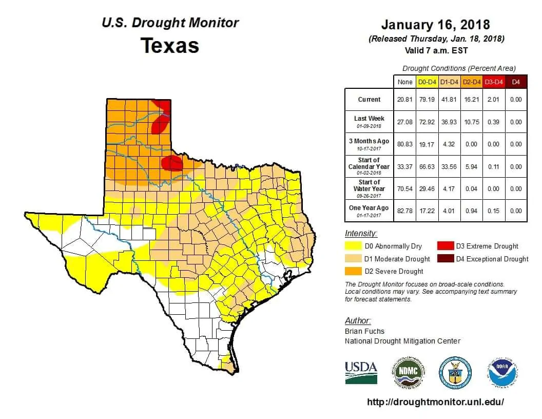
While Northeast Texas was the worst-off in late 2017, the Texas Panhandle, Northwest Texas, and West Texas have taken over that unwanted lead. We now have severe extreme drought conditions across the northeastern and eastern Texas Panhandle extending into Northwest Texas. Severe drought conditions include the remainder of the Panhandle and a majority of West Texas. Splotches of moderate drought encompass the Hill Country, Central Texas, North Texas, and portions of Northeast Texas extending south into the Piney Woods of East Texas. We also note that a chunk of the Coastal Plains – located between Corpus Christi and Houston – are now in moderate drought conditions. This does include locations that received biblical amounts of rainfall from Harvey last September, but little in the way of rain since. Recent winter weather events have produced liquid-equivilant totals under one-half inch in most locations that actually saw precipitation.
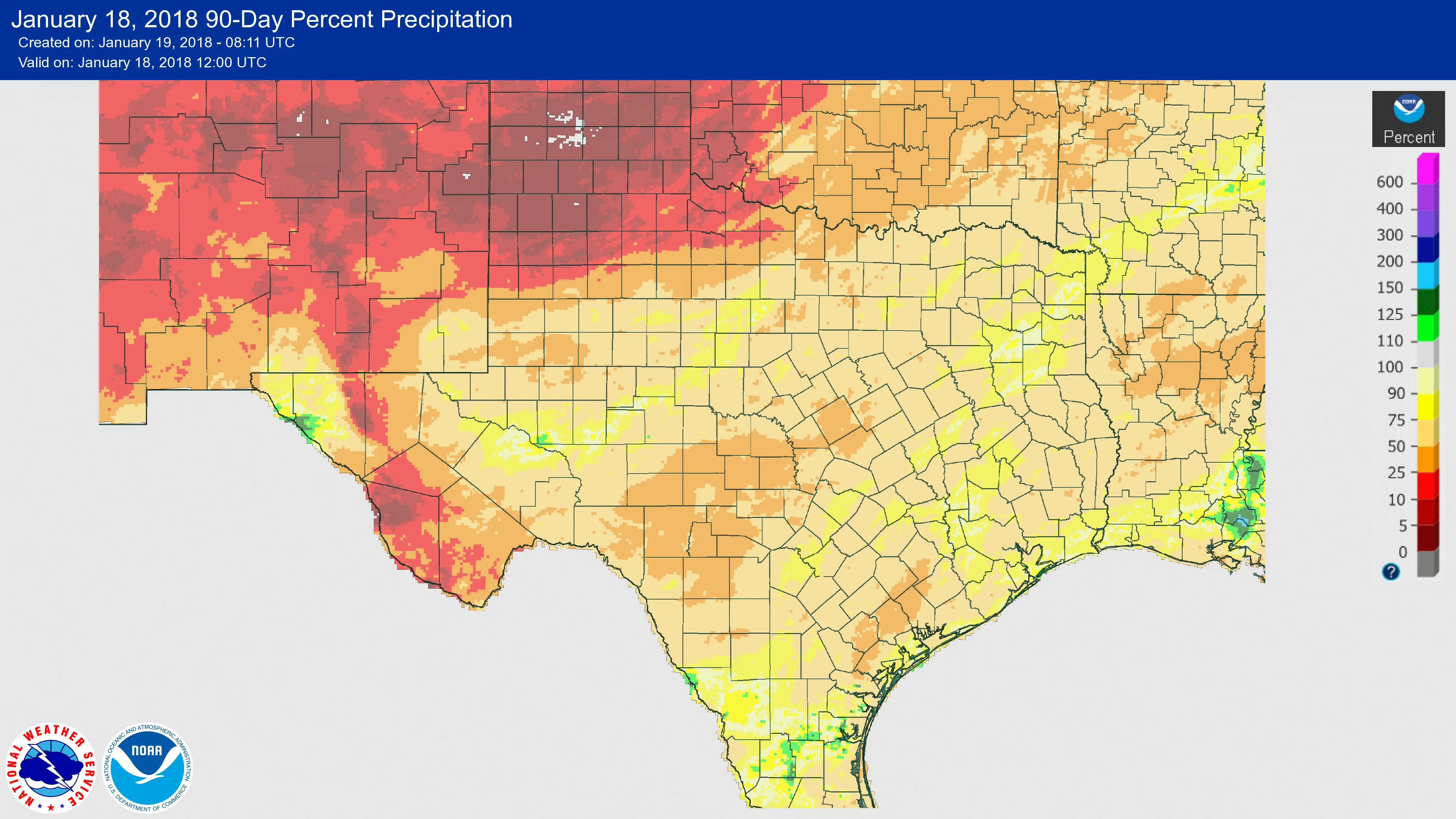
Percentage of normal rainfall observed over the last 90 days.
Rainfall over the last ninety days has been below-average over most of the state, although there are very few spots that are near or a bit above-average. Locations in the Texas Panhandle have not seen a quarter inch of rainfall in over 100 days. Some spots haven’t even seen any measurable rain since September! Precipitation-percentile based numbers over the last ninety days are at zero to five percent of average. Obviously, that has resulted in great hardship for farmers, a difficulty for livestock, and a tinderbox for wildland fires. In the short-term, the drought conditions will be most impactful to farmers who have winter crops, small watering holes for livestock, and an increase in ERC values. Energy Release Values (ERC) are a way to measure a surface fuel’s overall conduciveness to burn. Those values continue to rise and are above-average. With a transition to a spring-like pattern over the next week we’re going to have wind-makers roll through the Texas Panhandle, West Texas, and most locations west of Interstate 35. The dryline will surge east and we’ll see above-average temperatures and very low humidity values. Add in high winds (which are expected on Sunday as a strong upper-level storm system rolls through) and you’re looking at the potential for explosive wildfire growth. These situations will only grow more frequent as we continue toward early-spring and the usual ‘wind makers’ that roll through every week or so.
The forecast for the next week does indicate some rain potential across Northeast Texas, East Texas, Southeast Texas, and the immediate coast in the Coastal Plains, the Middle Texas Coast/Coastal Bend, into the Rio Grande Valley. Rainfall amounts of a one-quarter inch up to locally one inch will be possible over the next week. Most of that rain will probably fall on Sunday as a storm system moves from west to east. A second storm system is possible late next week. These forecast rain totals won’t put a dent in the developing drought, but they will temporarily postpone its development. Locations west of Interstate 35 are not forecast to see any rain whatsoever in the next seven days, and there are signs that could continue through at least ten days. Continued intensification of the drought is expected west of Interstate 35 with the worst-off locations (the Texas Panhandle and West Texas) possibly not seeing measurable precipitation through the end of January. Hopefully, that changes, but trends have not looked encouraging. This has the potential to be a bad wildfire season.


0 Comments