
A few different players will make or break a potential winter weather event Monday Night into Tuesday. Before everyone ends up all excited and raids the grocery stores, let’s keep in mind that a lot will change between now and Monday. Forecasting winter weather in Texas is difficult and there are always a few surprises that unfold during an event. I don’t think I need to remind anyone of that considering what all has transpired over the last two months. Here are a few important things to remember when talking about winter weather.
- Temperatures are important; not only at the surface but in the entire atmospheric column. A warm layer of air above the surface could result in a freezing rain/sleet event versus snow. If the entire column is below freezing the precipitation type would be snow. If there was a layer of warmer air above the surface the snow would fall through that, melt, and either reach the surface as freezing rain or sleet. (I’m not going to complicate this even further by describing the processes that turn snow into rain and back into sleet. Let’s just say it has to do with how much cold air is between the surface and that warmer layer above.)
- Accumulation forecasts are tricky and eventual totals tend to vary substantially over small distances. A mixed-mode of winter precipitation will lower accumulation forecasts, while ‘all snow’ would tend to result in higher accumulations. Soil/ground temperatures also play a role in how much ‘sticks’.
- Timing is everything. If a storm system is a bit too early or too late then the event ‘busts’. Temperatures need to be right for a winter weather event, and that’s also quite difficult to ‘time right’ with a storm system.
- There will always be a surprise or two. Whether that be a different precipitation mode thanks to slightly warmer air aloft or localized bands of enhanced precipitation (thus locally higher accumulations).
- Finally and most important at this stage – we’re still 2+ days out. What it may look like in data this morning could easily change drastically by tonight. The smallest changes in a storm system now – say a track ten miles farther south in the coming hours – translate into a nearly one-hundred mile shift by the time it gets here Monday night. That doesn’t even take into account the freezing line location (which will be moving during the event) and how much moisture is available.
The first player for our upcoming winter weather changes will be a very potent cold front. This arctic cold front is going to bring a very cold airmass in with it – and the speed of the front will dictate where the freezing line ends up as precipitation is ongoing. If the front is slightly faster or the airmass colder then temperatures could drop below freezing more quickly.
The second player will be an upper-level storm system. That storm system will be partly responsible for our arriving arctic cold front. Increasing lift will arrive Monday Night with precipitation developing. Where temperatures are below freezing that precipitation will either be freezing rain, sleet, or snow. Again – we can’t tell yet exactly what the overall temperature profiles will be, so we can’t say if it’ll be freezing rain/sleet or more of a sleet/snow. Where temperatures are above freezing the precipitation mode will be liquid rain.
For our third factor – moisture. How much moisture will be available Monday Night into Tuesday, and how much of that will be able to fall as winter precipitation? Some models indicate we’re only going to see a tenth of an inch of precipitation while others are closer to one-half inch. A standard ratio for sleet is 3 inches of sleet per 1 inch of liquid rain – and 10 inches of snow per 1 inch of liquid rain. Those ratios are dynamic and will be different for each event depending on a number of complicated factors. Will we be dealing with a tenth of an inch of precipitation, one-hundredth of an inch of precipitation, or something higher? Again: That is one of the important aspects to any winter forecast that will be refined in the coming time period.
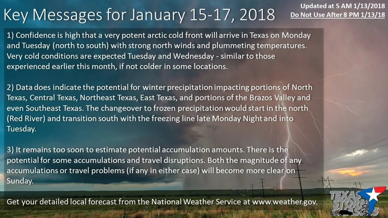
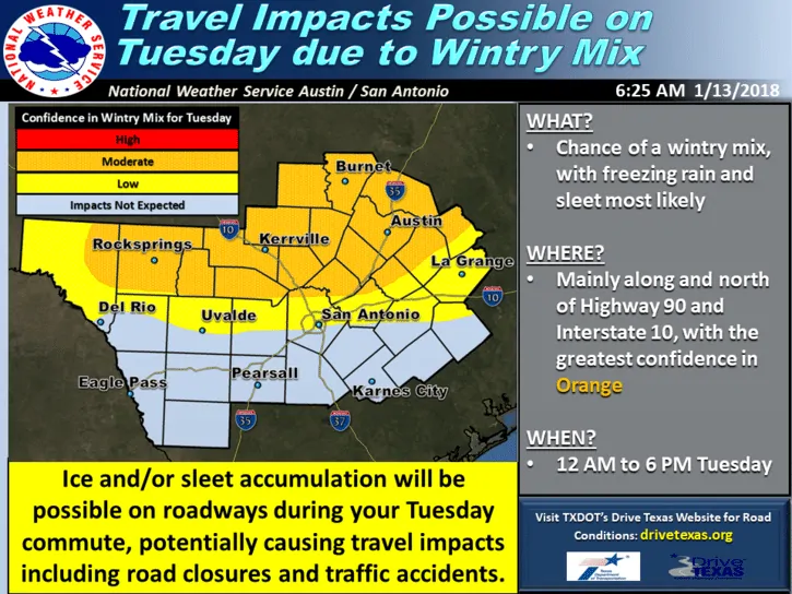
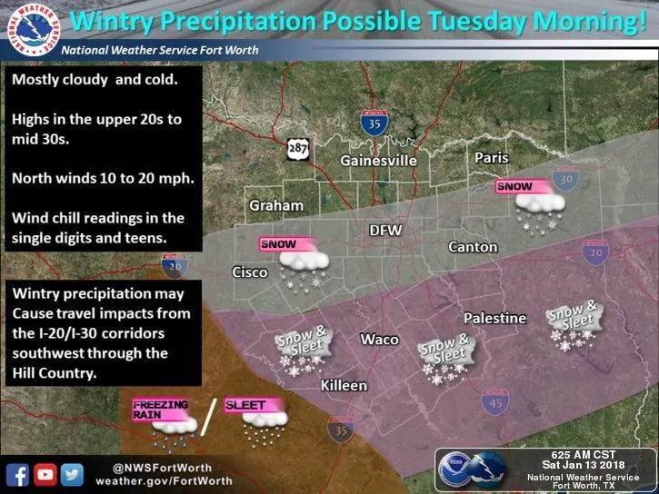
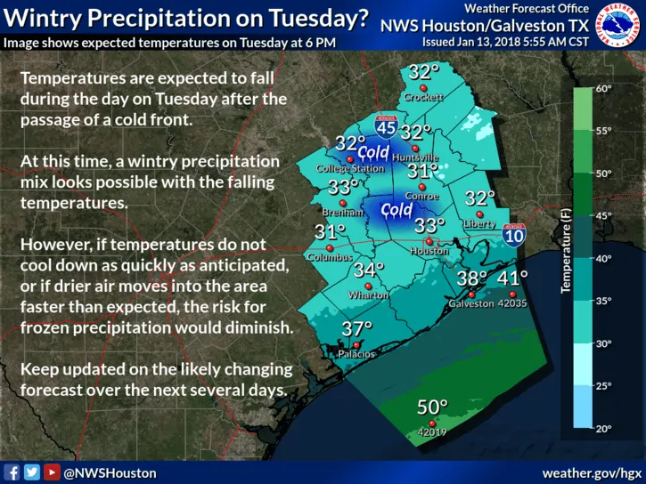
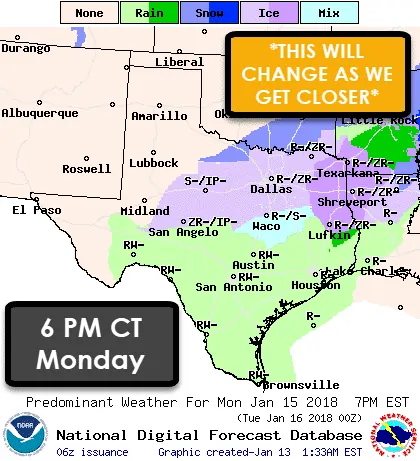
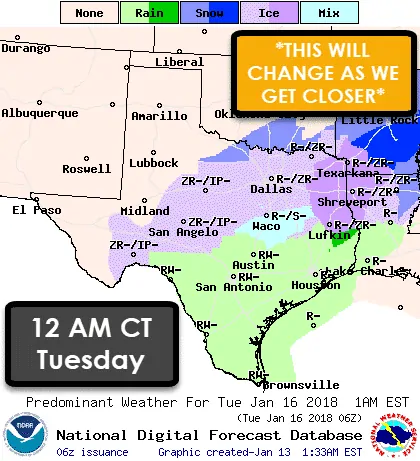
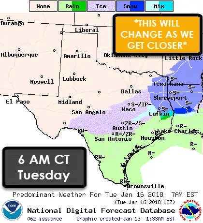
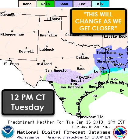
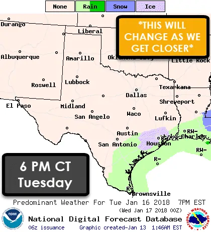
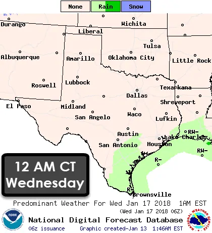
Here is the forecast graphical data from earlier this morning. The best advice I can give is for you to check your local forecast at the National Weather Service’s website at www.weather.gov. We’ll try and get a updated blog out around 3:30 PM with after we get a look at the morning data.


0 Comments