
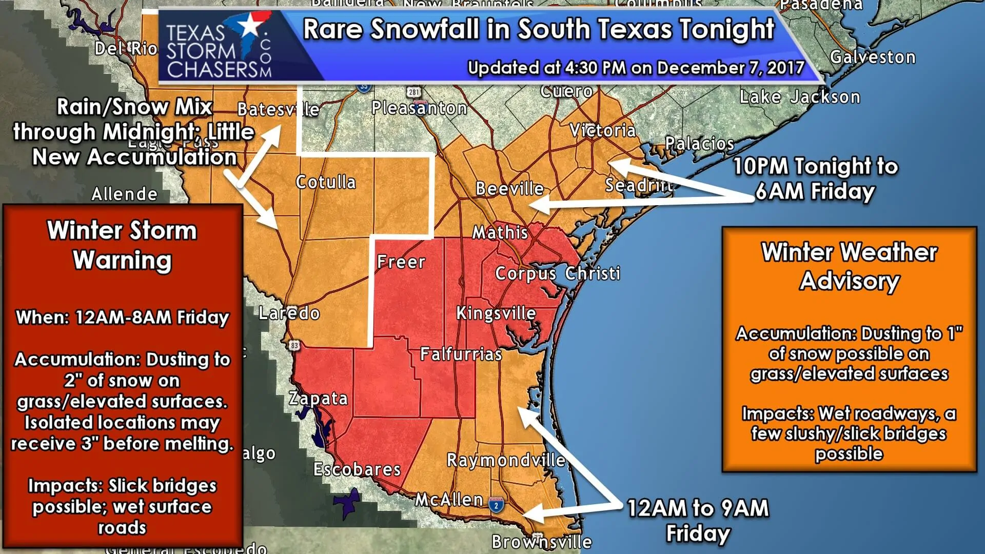
A rare winter weather event will unfold tonight across the Rio Grande Valley, Deep South Texas, South Texas, the Coastal Bend, the Coastal Plains, northeast into coastal regions of Southeast Texas. Surface temperatures look to remain above freezing for this event. Rain is expected to mix with or change completely to snow late tonight into the morning hours Friday. Temperatures above the surface will be going below freezing as cold air advects in from the north. Even with surface temperatures above freezing, the atmospheric column should become cold enough for snow. This setup isn’t dissimilar to the Christmas 2004 winter storm, but temperatures will be warmer this time around. The highest snowfall accumulations are expected to occur in the Winter Storm Warning. There we may see accumulations of a dusting all the way up to two inches, perhaps an isolated three-inch snow amount on grass and elevated surfaces. Most surface roads will remain wet, but could temporarily see some snow cover or slush if a heavier burst of snow occurs. A dusting to one inch of snow is possible in the Winter Weather Advisory (orange shading) tonight and Friday morning. Again, these accumulations are likely to occur on the grass and elevated surfaces. A few bridges may become slick with slush, but surface roads should stay wet. Farther northeast into Southeast Texas we’re expecting the precipitation to end before too much snow can mix in. The exception could be within about 40 miles of the coast where cold air could arrive just in time to support a change-over to snow. Little to no accumulation is anticipated at this time, but I wouldn’t be surprised to see a quick dusting of snow. All regions above will see any snow accumulations melt within a few hours as soil temperatures remain well above freezing.
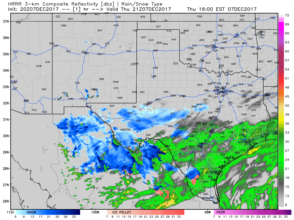
This simulated model radar runs from this afternoon through Friday morning at 8 AM CT. Timestamps are on the top-right part of the graphic in eastern time (so subtract an hour). We should be seeing precipitation come to an end across most of the state by 8 AM, but some snow could be ongoing across Deep South Texas and the Rio Grande Valley. Surface temperatures should be above freezing in locations that see snowfall, so we’re not expecting surface roadways to become icy, but there could be some slush for a while. There is the possibility of some slick bridges due to slush accumulation, but that should melt fairly quickly.
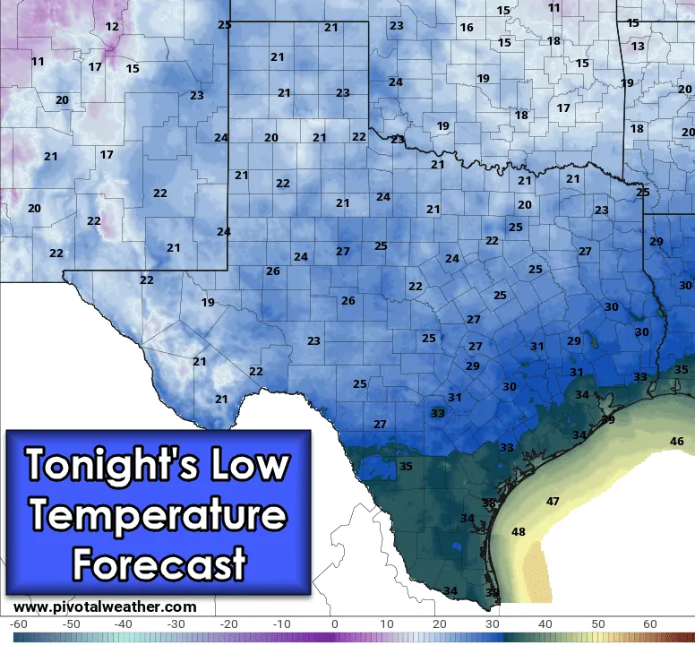
Outside of precipitation chances, the entire state will be dealing with cold weather tonight. The freezing line is anticipated to make it south of San Antonio east to the north side of Houston to near Beaumont. Locations north of that line – a majority of Texas – will see temperatures in the upper teens to twenties tonight. Any residual water left on roadways will likely freeze into black ice by morning. Please be mindful of ice caused by sprinklers or from residual wet spots. Otherwise, make sure your pets are warm, plants are protected, pipes are in good shape, and that any elderly or susceptible neighbors have a warm place to sleep.


0 Comments