
The strongest cool front we’ve seen in a couple of weeks will bring an end to above-average temperatures for most, at least for a little while. That front will begin pushing south into the Texas Panhandle this afternoon. It’ll continue moving south tonight and into Tuesday. Before we get to the cool front let’s chat about what we can expect today.
A surface dryline will slowly march east this morning into the afternoon hours. By about 3 PM the dryline should be located from near Sanderson to Sterling City to Abilene northeast to Graham north to Henrietta. Dewpoint temperatures west of the dryline will be in the 20s and 30s. Extremely dry air will be moving into the Texas Panhandle this afternoon where dewpoints will fall into the single digits, perhaps below zero by this evening. Relative humidity values will be low and surface winds could be gusting over 25-30 MPH in some locations – both west and east of the dryline this afternoon. Fire weather conditions will be near-critical. Any grass fires that develop west of the dryline today could be difficult to contain. On a scale from zero to three – the flaming tumbleweed scale will be at about 1.5 for today. One day I’ll put a great graphic together for that…
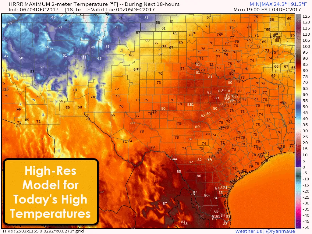
At least I won’t be saying this for the rest of this work-week, but temperatures will be quite warm today. Highs will likely range from the middle 70s all the way up into the middle 80s. The exception will be the Borderland, higher elevations in the Trans-Pecos south toward Alpine and Marfa, and in the Texas Panhandle along with West Texas with the upper 60s to lower 70s expected. A few upper 80s in Deep South Texas could also occur if daytime heating is feeling extra productive. [clickToTweet tweet=”Temperatures this afternoon will peak 10 to 25 degrees above average for early December across Texas. ” quote=”Temperatures this afternoon will peak 10 to 25 degrees above average for early December across Texas. “]
Now for the cool front’s timing. Keep in mind these buggers have a tendency to be a tad faster than expected, so don’t be shocked if it arrives a bit early. You’ll know the cool front has arrived when winds start gusting out of the north/northwest at a good clip. Cooler air will lag a couple hours behind, but you should notice an immediate drop in humidity/moisture. A more substantial temperature gradient will accompany the front’s leading edge on Tuesday once it makes it toward Interstate 10.
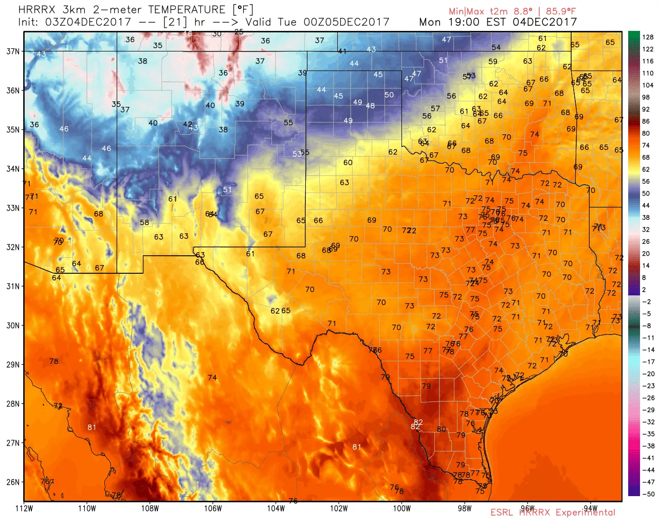
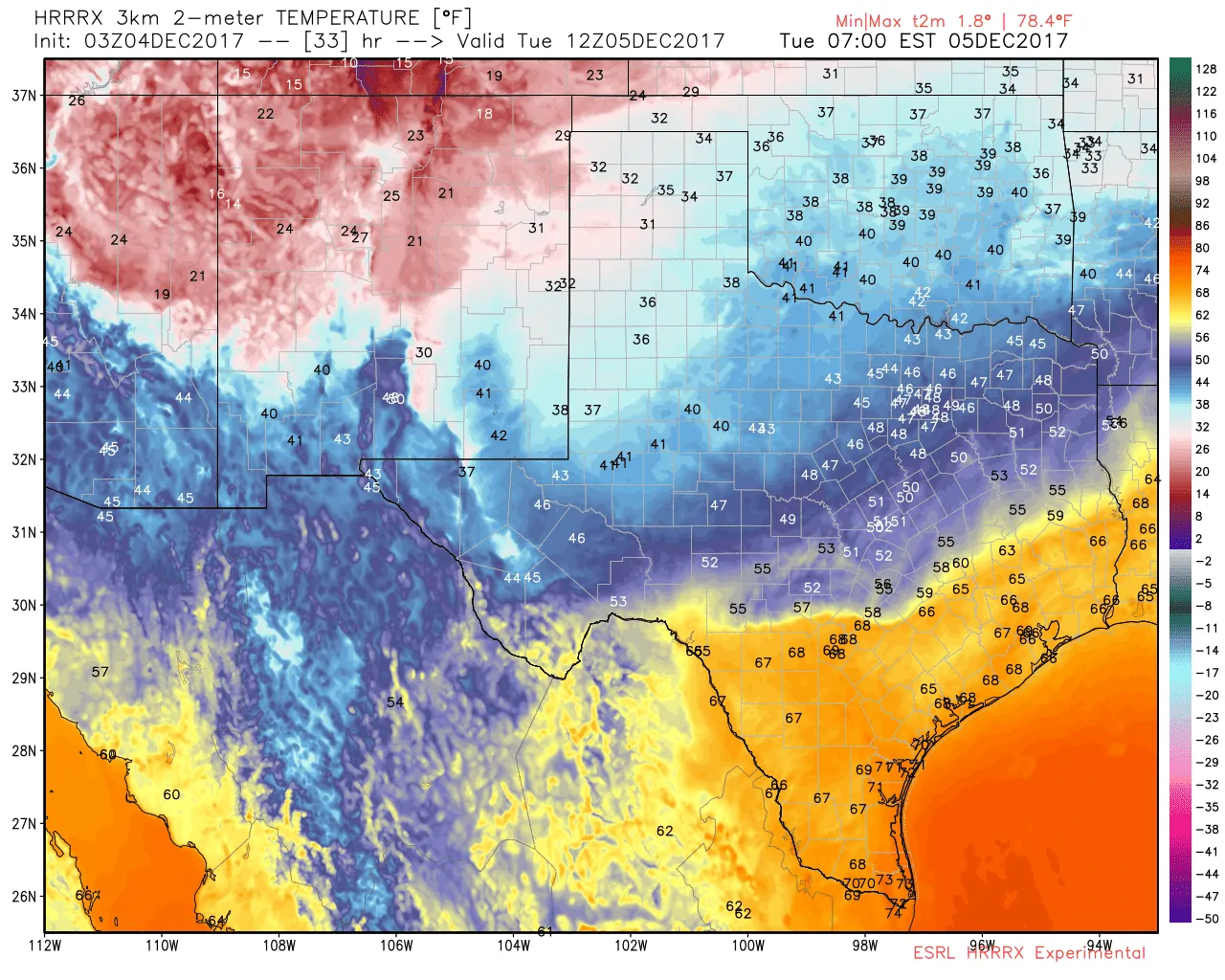
03Z HRRRx surface temperatures at 6 PM this evening.
At around 6 PM this evening the leading edge of the cool front should be near Friona to Dimmitt to Plainview to Paducah to near Wichita Falls – extending northeast to near Ardmore, Oklahoma. Temperatures immediately behind the front will drop into the 50s and 60s, but the 40s won’t be far behind.
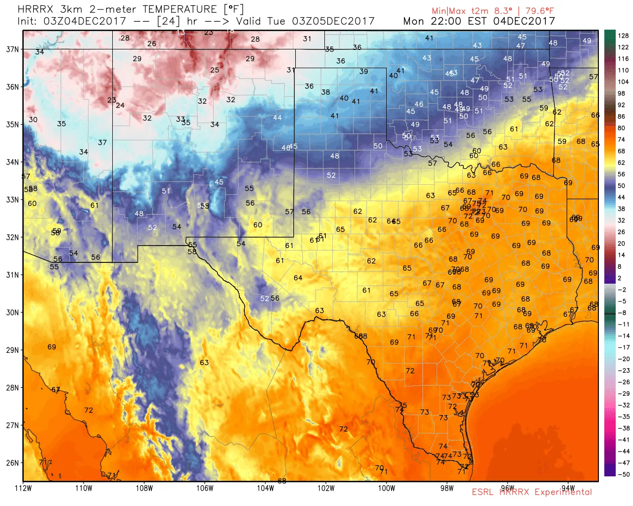
03Z HRRRx surface temperatures at 9 PM this evening.
Three hours later at 9 PM, the front will be racing south through the Big Country and North Texas. The leading edge should be near Morton to Lubbock, with more of a push south farther east near Snyder to Anson to Mineral Wells northeast to Denton and Sherman. Gusty north/northeast winds of 15 to 40 MPH are expected. This is the timeframe where the cooler air may lag back a few hours behind the initial wind shift.
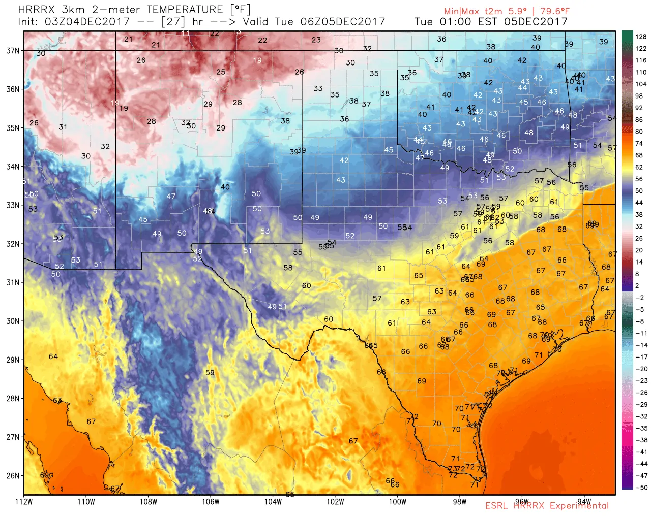
03Z HRRRx surface temperatures at midnight tonight.
Around midnight Tuesday, the leading edge of the front will be moving into the Trans-Pecos from Kermit, through the Permian Basin near Crane, into the Big Country and northern Edwards Plateau near Big Lake, east into the Hill Country near Brady. The leading edge of the front should be between Waco and Temple in Central Texas, extending toward Fairfield, Tyler, to Jefferson in East Texas. Gusty north/northeast winds of 15 to 40 MPH will accompany the front. Temperatures behind the front will drop from the upper 60s into the 50s. By midnight the Panhandle will be in the 30s, with 40s as far south/southeast as West Texas, Northwest Texas, and Texoma.
03Z HRRRx surface temperatures at 6 AM Tuesday.
Fast-forward an additional six hours and at 6 AM Tuesday the leading edge of the front should be near Del Rio to San Antonio east to near Bryan/College Station to Hemphill. Winds behind the front won’t be as gusty on the far East Texas portion of the front, but those from about B/CS west into the Edwards Pleateau will continue dealing with strong northerly winds. Temperatures behind the front may take a few hours to start falling, but there will be a 10 to 20-degree drop in the following three hours. It looks like the cool front will arrive in the Houston metro around 9 AM – northern areas a tad sooner and later for places like Richmond, Alvin, Angleton, and Galveston.
The cool front will not bring precipitation to the western half of Texas. As a whole, we’re not expecting this front to be particularly convective, but a thin line of showers (perhaps thunderstorms) could accompany it as it moves south through Northeast Texas and parts of North Texas this evening. A strong storm with gusty winds up to 55 MPH can’t be ruled out in Northeast Texas. The risk for strong storms will be highest from 8 PM to 12 AM tonight. Any thunderstorms that develop will weaken toward midnight as the front pushes south into Central Texas and East Texas. A few showers will likely accompany the front tonight into Tuesday morning as it moves south. Rainfall amounts are not expected to be impressive, nor high enough to cause any sort of flooding issue. We may see a few showers develop ahead of the front in Southeast Texas and behind it in East Texas during the morning hours Tuesday. Neither sector is expected to experience severe storms.
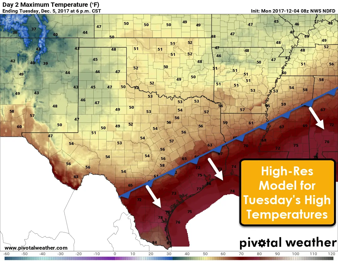
High temperatures on Tuesday will remain in the 40s and 50s behind the cool front. This graphic is a bit deceptive. While it does show peak temperatures on Tuesday, those may be in the morning hours across South Texas and Southeast Texas. Once the cool front arrives at your location temperatures will begin to fall. The only spot that may actually see their highs in the afternoon could be in Deep South Texas and the Rio Grande Valley. No worries though, your relief from the heat will arrive Tuesday evening.
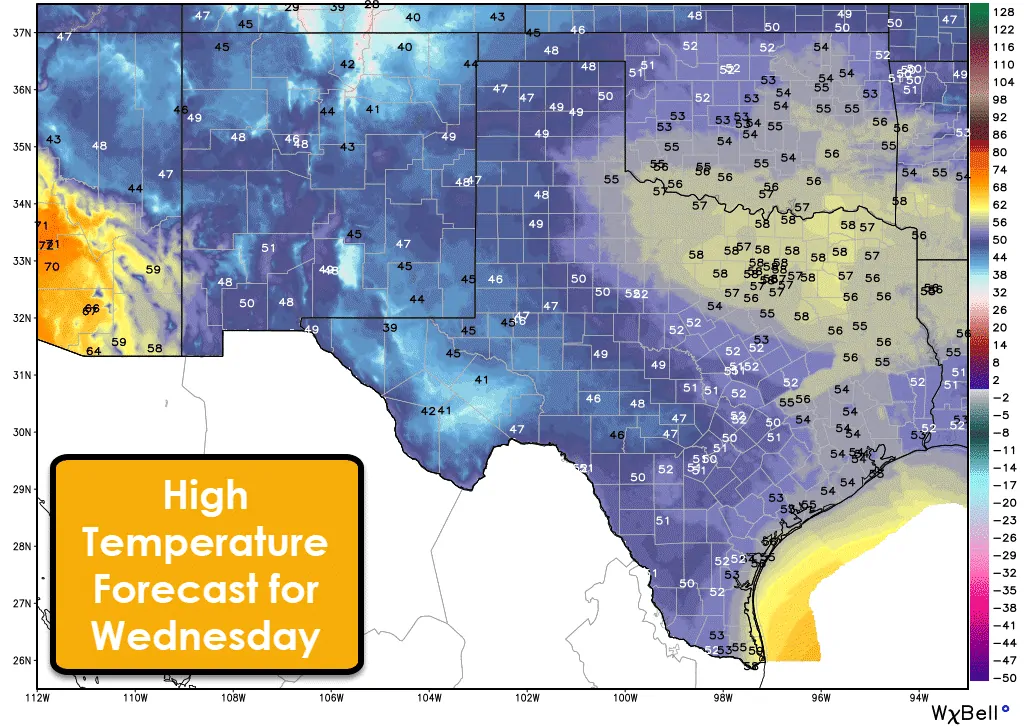
On Wednesday we’ll see high temperatures uniformly in the ‘fall’ category across Texas. The lowest look to be in the higher elevations around Marfa and Alpine – who will struggle to get out of the 30s. The warmest should be in North Texas and Northeast Texas with middle to the upper 50s. Everyone else in the state will only top out in the 40s to lower 50s on Wednesday as precipitation increases.
Atmospheric lift will increase on Wednesday across the southern half of Texas. As this occurs we’ll see areas of precipitation develop. Most of this precipitation will be light to locally moderate. We’re not expecting any severe thunderstorms or flood-producing rainfall. A corridor from the Alpine/Marfa area east through the Edwards Plateau into the Coastal Plains could see up to an inch of rainfall on Wednesday/Wednesday Night. Up above are the chance of precipitation graphics from Wednesday through Thursday. Remember: They show the chance of receiving precipitation. They don’t mean how much of the time it’ll rain, or how much rain.
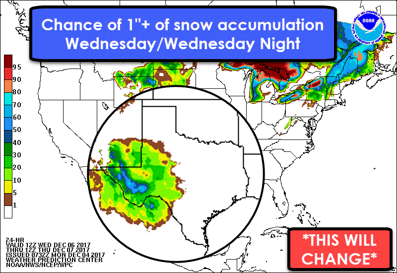
Things get real interesting on Wednesday and Wednesday Night. Let me start off by saying for a majority of folks this period will either be dry and cool or feature a cold rain with temperatures in the upper 30s to 40s. Most snow lovers should not get their hopes up. The best chance for at least a dusting of snow on Wednesday and Wednesday Night will be in the higher elevation of the Trans-Pecos – around Alpine and Marfa for example. Temperature profiles are going to play a huge role in determining precipitation type. A literal one to two-degree difference will dictate whether we have rain with some snow mixed in, have some sleet, or have all snow with the potential for accumulations. By Wednesday Night we could see a rain/snow mix farther east/northeast into the Permian Basin and Edwards Plateau, although I stress that accumulations don’t look likely at the moment. We all know winter weather events are difficult to forecast out 24 hours in Texas, so check back tonight for the latest forecast – it will likely have changed somewhat.
Temperatures look to stay on the cool side through Thursday as rain chances become confined to South Texas. We’ll start a warming trend on Friday from south to north. That trend will continue into the weekend with 50s and 60s state-wide by Saturday and Sunday.


0 Comments