
This Morning
Showers and thunderstorms that impacted San Antonio and Austin earlier this morning will continue moving northeast through the Brazos Valley and toward Northeast Texas and East Texas. Severe weather is not anticipated with this activity, but locally heavy rainfall is probable. More widely scattered showers will continue impacting the Edwards Plateau, Hill Country, Central Texas, Brazos Valley, and North Texas through the late morning.
This Afternoon
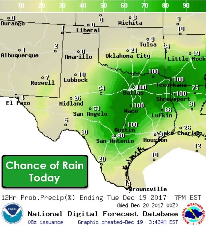
The convective setup this afternoon remains a bit uncertain, but we have a couple players at bat. A warm front is expected to lift north across Central Texas into the Piney Woods of East Texas this afternoon. It wouldn’t be surprising to see it near Interstate 20 from east of Dallas to Shreveport by about 3 PM. The eventual location of the warm front is important since it’ll dictate the northern edge of surface-based instability (more on that in the severe weather section below). A line of thunderstorms may develop as far west as Jacksboro to Goldthwaite by 2 PM. This thin-line of storms may produce gusty winds of 40 to 50 MPH along with very heavy rainfall as it moves east. Should this scenario play out as I timed above the line of storms would be moving through the D/FW Metroplex from west to east during the 3 PM to 5 PM timeframe. There will be a marginal risk of severe weather during that time-frame. By 6 PM the leading edge of the storms will probably be east of the D/FW Metroplex – near Clarksville to Canton to Corsicana and Waco.
Severe Weather Threat This Afternoon/Evening?
The severe weather threat today is conditional on thunderstorms becoming surface-based, or tapping into the more moisture-rich airmass near the surface. The location of the warm front will dictate which storms have that opportunity. Storms along and south of the warm front have a comparatively higher chance of becoming surface based, with a chance of producing some stronger wind gusts of 45 to 60 MPH. Very strong wind-shear is in place in the low, mid, and upper-levels of the atmosphere. The limiting factor for a more widespread/substantial severe weather threat is a typical hindrance this time of year – atmospheric instability, or convective available potential energy (CAPE). With so much moisture in place, the atmosphere is more conducive for heavy rains than severe storms. However, we cannot discount the strong wind shear in place. Even though ‘CAPE’ values are going to be near 300-500 (spring can often times see values over 3500 on a normal day), we need to watch any storms near that warm front.
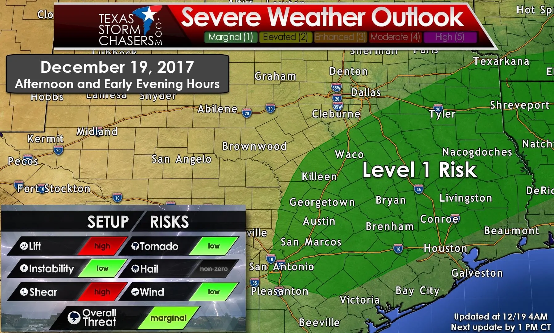
A marginal risk of severe weather is forecast by the Storm Prediction Center this afternoon and early evening. Again; the risk is on the low-end of the spectrum. This is not a day where I expect long-lived tornadoes, nor many tornadoes. If anything; if we even had a tornado or two develop today, they’d likely be weak and brief. That would be little consolation if one of them came down your street, so I encourage folks to have a way to receive weather warnings just in case we do see a few tornado warnings today. The highest potential for a brief tornado (relative to the low-end setup) is from Dallas and Hillsboro points east/northeast to Texarkana and Shreveport. The risk for brief tornadoes is conditional on storms actually becoming surface-based long enough to spin-up. Otherwise, some higher winds of 45 to 60 MPH are certainly possible in stronger storms. If confidence increases in a slightly higher corridor of severe weather potential we could see a small level 2 risk introduced in later outlook updates, or the risk area pulled a bit north. As the late Al Moller from the NWS Fort Worth would say – “When it comes to thunderstorms expect the unexpected.” So we’ll keep an eye on things and post updates throughout the day.
This Evening into Tonight
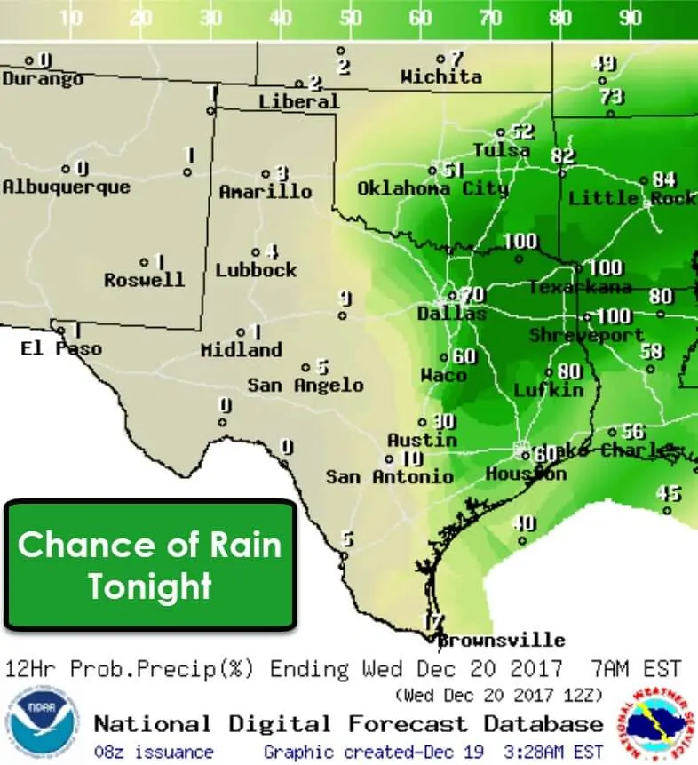
By midnight we should see rain coming to an end, if not concluded entirely, across North Texas, Central Texas, into the Brazos Valley and all points west. A line of showers and perhaps thunderstorms could still be underway from near Texarkana to near Lufkin, with a few showers possible farther southwest. All this activity will continue pushing east and will be outta the picture by sunrise Wednesday. Beneficial rain totals are expected across Northeast Texas, through the Piney Woods of East Texas, back down into the Brazos Valley. Considering Northeast Texas is now in severe drought conditions, this rainfall will really help out.
Looking Ahead toward Christmas
The much-advertised potential winter weather threat that some weather models were showing for this upcoming weekend is no longer expected. There is the potential we could see a few snow flurries from the Texas Panhandle southeast through Texoma on Christmas Eve (Sunday), but that looks quite light at this point with no impacts. The primary impact, and you’ll certainly notice this one, is the very cold airmass expected to arrive in time for Christmas.
These are certainly subject to change based on the timing of a cold front, but we definitely will not be experiencing 70s and 80s for a second Christmas in a row. In fact, temperatures are going to be downright cold. If even colder weather model solutions were to verify these temperatures would need to be lowered in future forecasts, but we’ll deal with that after we get through today’s storm system. The extended range between Christmas Day and New Years looks cold.


0 Comments