
A week before Christmas and all through the state were kids and adults wondering their snow-fate. I’m sad to say, yet relieved as well, that it no longer seems likely that we’ll have to deal with that icy hell. Don’t blink just yet because you never know what Santa might bring from his arctic home. Weather models giveth and taketh away, yet confidence is high that it’ll be cold come Christmas Day. Just how cold we become and how long it stays is something we’ll fine-tune in time for that magical day. Always remember that no matter the time – the forecast could change at the turn of a dime.
See what happens when I end up starting at weather models too long? My head turns to mush and I start rhyming. If you couldn’t get through the first paragraph without face-palming I’ll quickly summarize. A majority of weather models and their ensembles have backed off the idea of a pre-Christmas winter weather event in Texas. That trend has continued since the evening model runs back on the 16th. We’ll continue to keep an eye on things just in case we swing back around for another round of fun. For now, everyone can breathe a sigh of relief that their travel plans aren’t going to be spinning on ice. Now that we’ve got that out of the way let’s talk about the weather right in front of us.
You can thank recent rainfall and clearing skies for this morning’s drive to work treat. Who doesn’t like being able to see two car lengths past their hood? The dense fog may continue in some locations until mid-day, but we should all have visibilities improving by the early afternoon.
The primary focus in the short-term will be on our upcoming widespread precipitation event for locations near Interstate 35 and points east. Scattered showers will be possible today and tonight from the Edwards Plateau northeast to North Texas – and points east/southeast. I don’t anticipate many storms tonight as the atmosphere will be primed for more fog, mist, and showers.

Precipitation chances increase on Tuesday as widespread showers and a few thunderstorms move east in association with an upper-level storm system. Some rainfall may be heavy at times and this will be a good ‘ole needed soaker. By the evening hours heading into Tuesday Night, the highest rain chances will be across Northeast Texas and East Texas before moving out completely by Wednesday morning. I know you all have your preferred weather apps that can provide specific and local chance of rain/timing, so I’ll forgo making too much noise about that.
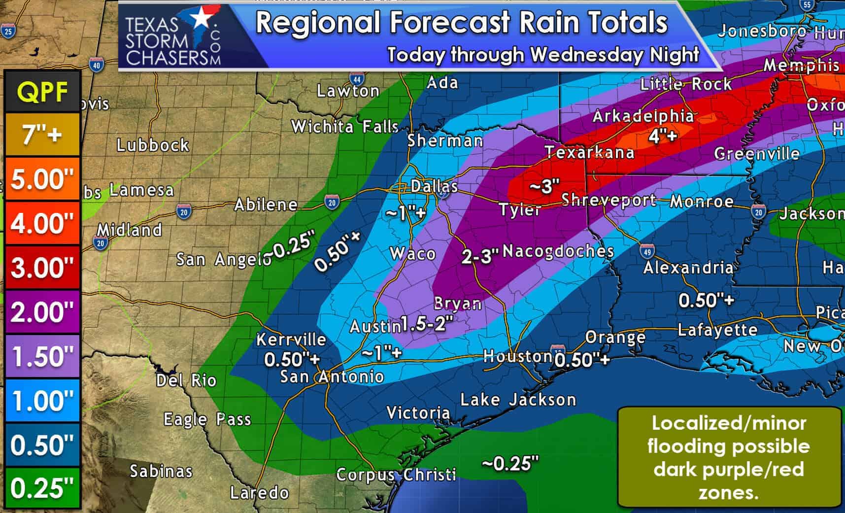
As stated above we’re due for a good soaking. It looks like we should see at least one inch of rainfall across the eastern half of North Texas, bisecting D/FW as usual, south into the Brazos Valley, Northeast Texas, and East Texas. A heavier band of rainfall looks to set up across Northeast Texas. The irony isn’t lost on me considering the severe drought conditions, but localized flooding may occur under that heavier band of rainfall on Tuesday in Northeast Texas. Localized rainfall accumulations of 3 to 4 inches will be possible in Northeast Texas eastward into Southern Arkansas and the TN/MS border.
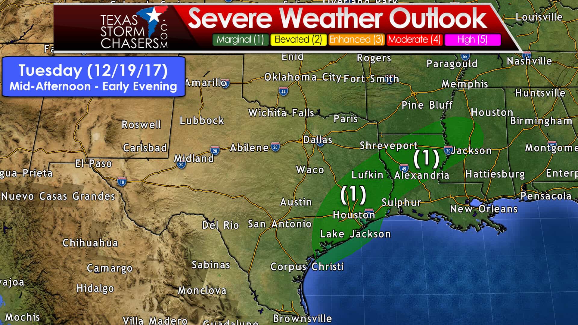
Severe weather is not expected to be an overly big issue on Tuesday, but we do have a few things to talk about. We’ve got a level one risk of severe weather in Southeast Texas and East Texas on Tuesday. On a scale from one to five, we’re at the bottom, a one. That means a few isolated severe storms are possible, but significant and widespread severe storms aren’t expected.
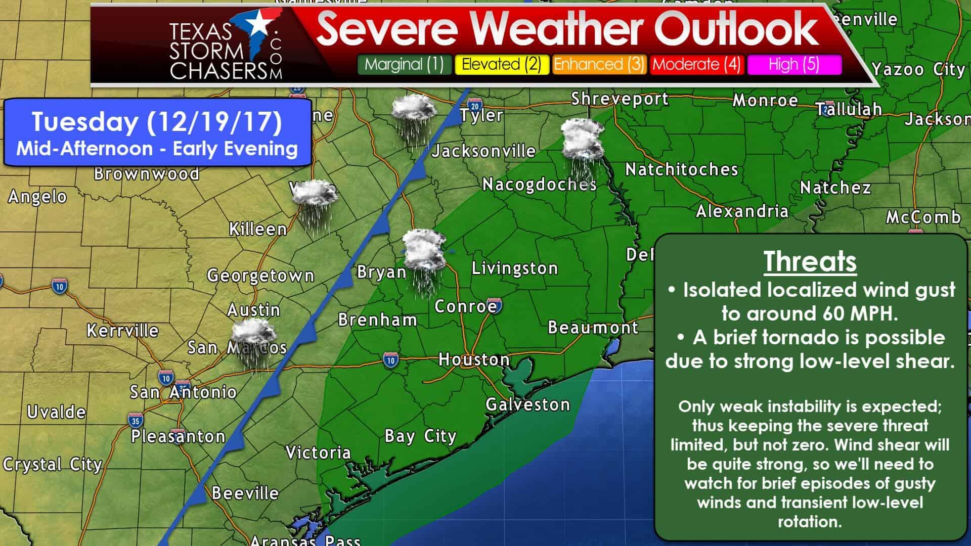
Here’s a more detailed graphic depicting the severe weather risk zone with more cities overlaid. Remember, storms don’t read maps, so don’t take the lines too literally. The setup for tomorrow will feature a moisture-laden atmosphere with lots of wind shear. No doubt we’re going to have plenty of spin in the atmosphere. Fourtinietly a limiting factor will be the modest available instability. Widespread cloud cover and rain should keep the atmosphere from getting too unstable. This high shear – low instability setup tends to favor a couple wind gusts of 45 to 55 MPH, perhaps a 60 MPH report. Strong wind shear, including in the low-levels, does support the possibility of a brief tornado. We’d need everything to come together just right for a tornado, and even if that happened it’s likely it would be brief and weak. Still; we’ll keep an eye on the setup and encourage you to keep up with the latest forecasts. The time-frame for any potential storm mischief looks to be from the mid-afternoon when the atmosphere is most unstable to the early evening – when storms begin to exit off to the east. If we ended up with more instability the threat of a few severe storms would increase a bit. Fall and early winter is our secondary severe weather season – especially in East Texas.
Christmas Day is now within the seven-day time-frame. Confidence is high that a strong arctic cold front will either have just moved through – or will be moving through Texas on Christmas Day. We will not have a repeat of the record warmth we saw last year, nor are we likely to see a blizzard like West Texas experienced in 2015. We’ll keep watching the data to see if we do end up with any storm systems in the extended range. The final week of December and 2017 up to the New Year looks cold, perhaps very cold at times. Head over to www.weather.gov and pop in your zip code/city for a detailed local forecast from the National Weather Service.


0 Comments