
‘Tis the season for the temperature roller coaster. For those new to our fun little ride let me provide you with an introduction. Monday was toasty, Tuesday was cool, today will be toasty, tomorrow and Friday will be cooler, and Saturday will be warmer before we start the cycle all over again. Doesn’t it sound like fun?! If it makes you feel better, the constant temperature swings even make my body ache after a while. Anyway, enough with the lack of details. Let’s dive into the weather forecast for the upcoming few days across Texas.
Today
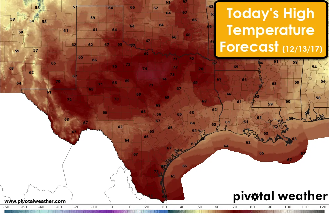
It’ll be a toasty and windy mid-December day across Texas. High temperatures this afternoon will peak in the 60s and 70s, with middle 70s expected in western North Texas. While these may sound ‘cool’ for the summer-time, we technically ended summer months ago. Christmas is in twelve days and the 70s aren’t exactly my definition of a winter wonderland. Keep those tomatoes in your pockets warm weather fans! We will have a cool front making progress from north to south tonight. It’ll make it through the Panhandle into West Texas this afternoon. Like usual you’ll know it has arrived once winds switch around out of the north and start blowing.
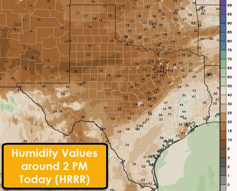
Nearly two months of little to no rainfall means surface fuels are quite combustible. One way of measuring surface fuel moisture, the Energy Release Index, is near record high values for this time of year. A very dry airmass will be in place today across the entire state. By the late morning and early afternoon relative humidity values will be below 20 percent across the northwestern half of Texas. RH values of 9-18 percent are expected in the Texas Panhandle, West Texas, Permian Basin, Northwest Texas, Big Country, Concho Valley, North Texas, Northeast Texas, Central Texas, into the Hill Country.
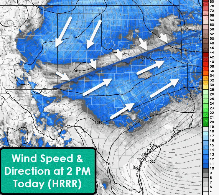
Around 2 PM winds will be gusting up to 25 MPH out of the north/northeast in the Texas Panhandle and West Texas as a cool front progresses south. Temperatures north of the front will fall into the 50s, but very dry air will keep relative humidity values low and fire danger near-critical. South of the front we’ll see southwest winds of 15 to 25 MPH from the Permian Basin east to Northeast Texas – encompassing the risk areas I mentioned in the previous paragraph. While this is not a high-end fire weather setup, the extremely dry surface fuels will result in a dangerous wildfire risk. Any grass fire that develops has the potential to spread very rapidly with spotting likely. Large grass fires are certainly possible and those would require a substantial number of resources to contain.
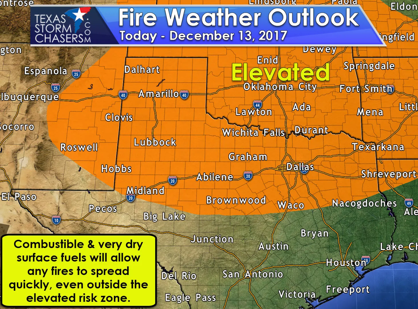
An elevated to near-critical fire weather risk has been delineated across the northern half of Texas. This zone is where meteorological factors will combine to support an elevated to near-critical fire weather risk. However; as I mentioned above, surface fuels are dry and relative humidity values across Texas will be low. Grass fires are certainly possible outside of the elevated risk zone. Please be extra vigilant when using outdoor equipment that could cause a spark. I really shouldn’t need to tell anyone to keep their cigarettes in their vehicle, but this isn’t a perfect world. Fire weather concerns will start to ease near sunset as relative humidity values begin to slowly increase and winds start to decrease.
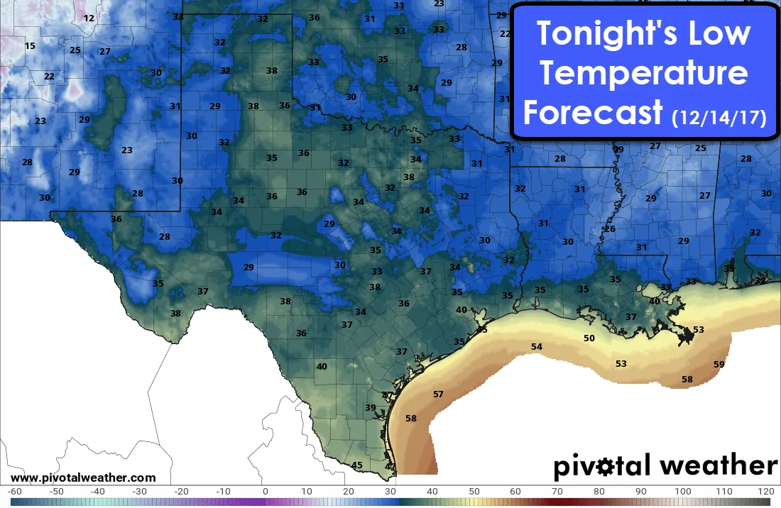
Tonight
Thursday
The cool front will continue to move south tonight with decreasing temperatures and northerly winds. That front in combination with a very dry airmass will allow for excellent radiational cooling potential tonight. That means we’re going to see temperatures drop off in a hurry after sunset. It’ll be a morning where temperatures could vary 5-10 degrees over a couple of miles, but it’ll be on the cool side.
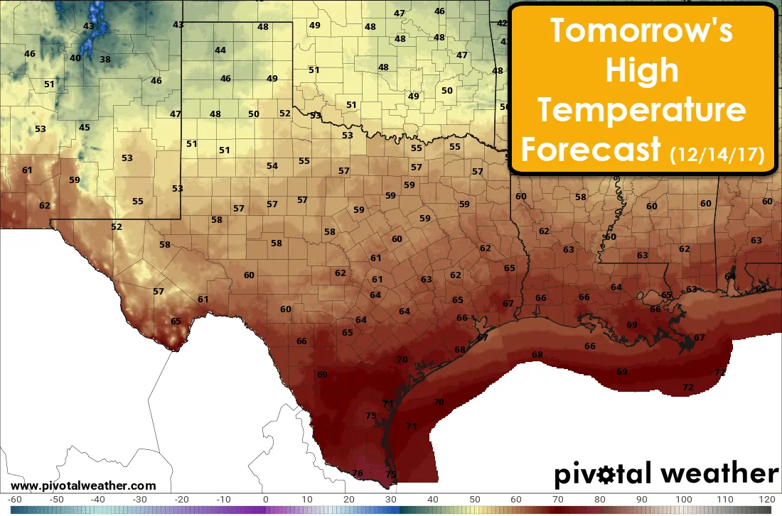
High temperatures on Thursday will be 15 to 20 degrees cooler than today across the northern half of Texas. It doesn’t look like the Texas Panhandle will get out of the 40s while 50s are expected from the Trans-Pecos and West Texas east through the Big Country and extending into Northeast Texas. Those in South Texas and the Rio Grande Valley will get to hang on to another warm day as the front won’t arrive until some point tomorrow afternoon. This frontal passage will be dry.
Increased Rain Chances Saturday Night into Sunday?
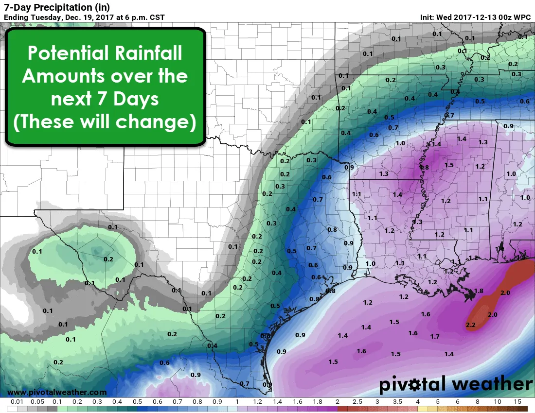
The forecast for Saturday and the weekend has changed since my blog yesterday. Weather model data is converging on a slightly faster and wetter solution. This is good news since it means the threat of a higher-end fire weather day is decreasing. I still anticipate near-critical fire danger across the Texas Panhandle, Northwest Texas, and perhaps the Big Country on Saturday, but we’ll start seeing moisture values increase east of those locations by Saturday afternoon.
There remain uncertainties over how widespread rainfall will become Saturday Night into Sunday. The Weather Prediction Center has the western edge of the rainfall roughly along Interstate 35 from the Red River south to Laredo. Rainfall amounts over a one-half inch are becoming increasingly possible across East Texas, Southeast TExsa, and into far South Texas and the Rio Grande Valley. Keep in mind these values are nowhere near high enough to produce flood concerns, but would at least put a very small dent in developing drought conditions. Check back in future blog updates for more details on when/where/how much rain we could see.


0 Comments