
This is going to be an interesting day. It isn’t often I get to talk about snow chances in Deep South Texas into the Coastal Plains and even Southeast Texas. Let me make it abundantly clear that we’re not looking at a repeat of the Christmas Day 2004 snow event. We’re not going to see half a foot of snow pile up on the beach. Surface temperatures look to remain above freezing for the duration of the precipitation event in those regions, so travel impacts are not anticipated. However; I would not be surprised if we saw a brief dusty on grassy and elevated surfaces across some parts of the aforementioned areas late today and tonight. Let’s dive into it!
Snowy in Far West Texas This Morning
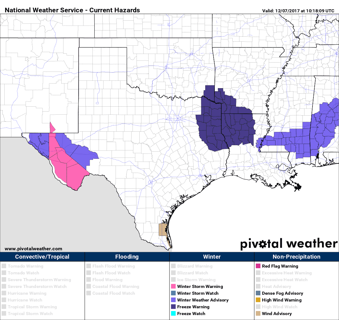
A Winter Storm Warning for significant snowfall continues from the Guadalupe Mountains south to the Chisos Mountains. This includes the Marfa Plateau. Now that the upper-level storm system is closer temperatures have become cold enough to support winter precipitation, mainly in the form of snow. Some of the snow in the higher elevations could be quite heavy today. Additional snowfall accumulations of two to six inches are anticipated with locally higher amounts. This includes the Davis/Apache Mountains. Heavier snowfall rates will allow accumulations on roadways. Temperatures tonight will be in the teens. Any snowfall that melts will re-freeze into ice tonight – including on roadways.
Lower elevations in the Upper-Trans Pecos and the Glass Mountains are under a Winter Weather/Travel Advisory. These locations will likely experience a rain/snow mix, perhaps all snow towards the afternoon hours. Snowfall intensity should be lower compared to the higher elevations, but one to locally three inches of snowfall may occur. Slushy roadways may be slick and any wet roadways will become icy tonight as temperatures fall into the teens and twenties.
Outside of the aforementioned regions, we are not anticipating any winter weather accumulations this morning or afternoon. Sufficiently cold air has saturated the low-levels of the atmosphere that a rain/sleet or rain/snow mix is occurring across portions of the Hill Country, South-Central Texas, and the Brazos Valley this morning. Surface temperatures are above freezing. Soil temperatures are well above freezing after recent warm weather. As temperatures warm into the 40s this afternoon we should start to see a change-over back to rain.
Winter Mischief Possible Tonight/Friday Morning in South Texas, the Coastal Plains, and Southeast Texas?
Precipitation chances will begin to end from north to south late today and tonight as drier/colder air moves in from the north. As is usual in the southern United States precipitation looks to end just before temperatures get cold enough to support a changeover to snow. However, that may not totally be the case in parts of South Texas, the Coastal Plains, and Southeast Texas tonight.

There are indications that temperatures in the lower levels of the atmosphere may become just cold enough to support a rain/sleet/snow mix for an hour or two before it shuts down. Surface temperatures look to remain above freezing, so no travel impacts are expected. I can’t rule out a brief dusting, but ground temperatures are so warm any accumulation would quickly.
Possible Scenerios for Tonight and Friday Morning
Now to cover a few scenarios since winter weather in Texas is often tricky to deal with…
- If temperatures ended up being a few degrees cooler than expected we could see a tad more sleet/snow mix come into play. This would possibly result in a dusting of snow on elevated objects and grassy surfaces. Surface objects would remain too warm for accumulations and no travel impacts would occur. Any accumulations would melt within an hour or two due to warm ground temperatures.
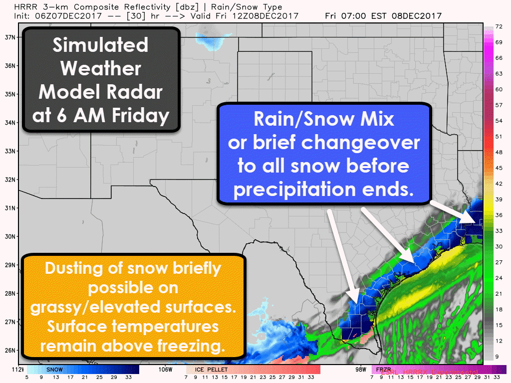
2. If temperatures ended up being a few degrees cooler and precipitation a bit heavier, we could see a brief switchover to all snow in portions of South Texas, the Coastal Plains, and Southeast Texas before precipitation came to an end. This would increase the possibility of a dusting to a one-half inch of snowfall accumulation on elevated objects. Again, accumulations would melt after an hour or two due to warm ground temperatures. Travel impacts would be unlikely, but we would have to watch for any slush on bridges.
Finally, it is quite possible that precipitation ends up ending with a few sleet pellets and snowflakes mixed in with rain. No accumulations.
Black Ice/Flash Freeze on Bridges/Overpasses Tonight?
Temperatures are expected to approach or drop below freezing close to and north of Interstate 10 in South-Central and Southeast Texas. Any residual moisture on bridges, overpasses, and elevated objects would have the potential to freeze into black-ice. This is not expected to be a widespread problem but is something to watch for tonight.
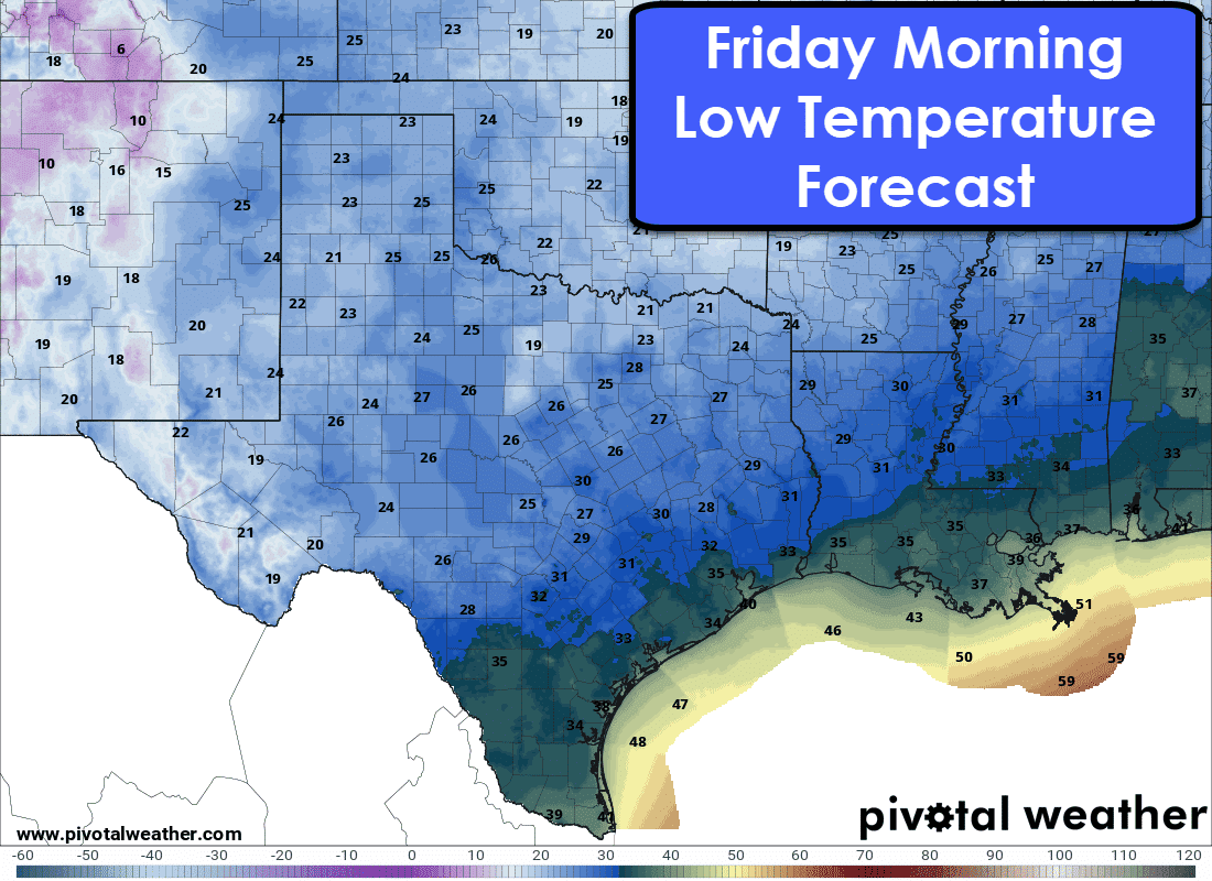
The freezing line by Friday morning is expected to be along a line from Eagle Pass to Pearsall to Humble to Beaumont. Obviously, local temperature variations will result in a more complex freezing line. Locations north of that line are expected to be at or below freezing (32 degrees Fahrenheit). There is some concern that residual water left on bridges/overpasses from rainfall today could freeze. A hard freeze (below 27 degrees Fahrenheit) is expected in locations along/north of the Hill Country, Central Texas, into the piney woods of East Texas. Don’t be surprised if some of North Texas (west/north of D/FW) ends up in the teens. Those expecting lows in the teens and twenties should take precautions. [clickToTweet tweet=”Sub-freezing temperatures expected tonight. Remember the 4Ps! People, Pets, Pipes, and Plants! @txstormchasers #txwx” quote=”Remember the 4Ps! People, Pets, Pipes, and Plants!”]


0 Comments