
The National Hurricane Center has resumed advisories on Harvey. It is expected to become a tropical storm later tonight, and will likely quickly intensify to hurricane status before making landfall on Friday along the Texas Coast. Major and potentially catastrophic flooding is likely across portions of the Coastal Plains and Southeast Texas this weekend and early next week as Harvey essentially stalls out. A more comprehensive blog post will be published shortly with more information on all the upcoming hazards.
Key Messages:
1. Harvey is likely to bring multiple hazards to portions of the
Texas coast beginning on Friday.
2. Several days of heavy rainfall are likely across portions of
eastern Texas, Louisiana, and the lower Mississippi Valley from
Friday through early next week. This rainfall could cause life-
threatening flooding. Please refer to products from your local
National Weather Service office (www.weather.gov) and the NOAA
Weather Prediction Center (www.wpc.ncep.noaa.gov) for more
information on the flooding hazard.
3. The National Weather Service has issued a Storm Surge Watch
from Port Mansfield to High Island, Texas. There is the possibility
of life-threatening inundation from rising water moving inland from
the coastline during the next 48 hours in these areas. For a
depiction of areas at risk, please see the National Weather Service
Storm Surge Watch/Warning Graphic, available at
hurricanes.gov.
4. The Potential Storm Surge Flooding Map will also be available on
the NHC website by 1200 PM CDT. Remember that the Potential Storm
Surge Flooding Map does not represent a forecast of expected
inundation, but rather depicts a reasonable worst-case scenario –
the amount of inundation that has a 10 percent chance of being
exceeded at each individual location. Because the Flooding Map is
based on inputs that extend out only to about 72 hours, it best
represents the flooding potential in those locations within the
watch area.
5. Hurricane conditions are possible along the Texas coast from
Port Mansfield to San Luis Pass.
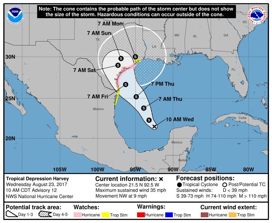
Tropical Depression Harvey Advisory Number 12
NWS National Hurricane Center Miami FL AL092017
1000 AM CDT Wed Aug 23 2017
…HARVEY REGENERATES INTO A TROPICAL DEPRESSION…
…HURRICANE AND STORM SURGE WATCHES ISSUED FOR PORTIONS OF THE
TEXAS COAST…
SUMMARY OF 1000 AM CDT…1500 UTC…INFORMATION
———————————————–
LOCATION…21.5N 92.5W
ABOUT 535 MI…860 KM SSE OF PORT OCONNOR TEXAS
ABOUT 470 MI…755 KM SE OF PORT MANSFIELD TEXAS
MAXIMUM SUSTAINED WINDS…35 MPH…55 KM/H
PRESENT MOVEMENT…NW OR 310 DEGREES AT 9 MPH…15 KM/H
MINIMUM CENTRAL PRESSURE…1006 MB…29.71 INCHES
WATCHES AND WARNINGS
——————–
CHANGES WITH THIS ADVISORY:
A Storm Surge Watch has been issued for the coast of Texas from
Port Mansfield to High Island.
A Hurricane Watch has been issued for the coast of Texas from north
of Port Mansfield to San Luis Pass.
A Tropical Storm Watch has been issued for the coast of Texas from
the Mouth of the Rio Grande to Port Mansfield and from north of
San Luis Pass to High Island.
The government of Mexico has issued a Tropical Storm Watch for the
coast of Mexico from Boca De Catan to the Mouth of the Rio Grande.
SUMMARY OF WATCHES AND WARNINGS IN EFFECT:
A Storm Surge Watch is in effect for…
* Port Mansfield to High Island
A Hurricane Watch is in effect for…
* North of Port Mansfield to San Luis Pass
A Tropical Storm Watch is in effect for…
* Boca De Catan Mexico to Port Mansfield Texas
* North of San Luis Pass to High Island
A Storm Surge Watch means there is a possibility of life-
threatening inundation, from rising water moving inland from the
coastline, in the indicated locations during the next 48 hours.
For a depiction of areas at risk, please see the National Weather
Service Storm Surge Watch/Warning Graphic, available at
hurricanes.gov.
A Hurricane Watch means that hurricane conditions are possible
within the watch area. A watch is typically issued 48 hours
before the anticipated first occurrence of tropical-storm-force
winds, conditions that make outside preparations difficult or
dangerous.
A Tropical Storm Watch means that tropical storm conditions are
possible within the watch area, generally within 48 hours.
Interests in southwestern Louisiana should monitor the progress of
this system for possible watches this afternoon.
For storm information specific to your area in the United States,
including possible inland watches and warnings, please monitor
products issued by your local National Weather Service forecast
office. For storm information specific to your area outside the
United States, please monitor products issued by your national
meteorological service.
DISCUSSION AND 48-HOUR OUTLOOK
——————————
At 1000 AM CDT (1500 UTC), the center of Tropical Depression Harvey
was located near latitude 21.5 North, longitude 92.5 West. The
depression is moving toward the northwest near 9 mph (15 km/h) and
a track toward the northwest or north-northwest is expected for the
next 48 hours. On the forecast track, Harvey should be approaching
the Texas coast late Friday.
Maximum sustained winds are near 35 mph (55 km/h) with higher gusts.
Some strengthening is forecast during the next 48 hours, and Harvey
could become a hurricane on Friday.
An Air Force Reserve Hurricane Hunter aircraft recently reported a
minimum central pressure of 1006 mb (29.71 inches).
HAZARDS AFFECTING LAND
———————-
RAINFALL: Harvey is expected to produce total rain accumulations of
10 to 15 inches with isolated maximum amounts of 20 inches over the
middle and upper Texas coast and southwest Louisiana through next
Tuesday, with heavy rainfall beginning as early as Friday morning.
Harvey is also expected to produce total rain accumulations of 3 to
9 inches in portions of south, central, and northeast Texas and the
rest of the lower Mississippi Valley. Rainfall from Harvey could
cause life-threatening flooding.
STORM SURGE: The combination of a dangerous storm surge and the tide
will cause normally dry areas near the coast to be flooded by rising
waters moving inland from the shoreline. The water is expected to
reach the following heights above ground if the peak surge occurs at
the time of high tide…
Port Mansfield to High Island…4 to 6 ft
The deepest water will occur along the immediate coast near and to
the northeast of the landfall location, where the surge will be
accompanied by large and destructive waves. Surge-related
flooding depends on the relative timing of the surge and the tidal
cycle, and can vary greatly over short distances. For information
specific to your area, please see products issued by your local
National Weather Service forecast office.
WIND: Hurricane conditions are possible within the hurricane watch
area by late Friday, with tropical storm conditions possible by
early Friday.
SURF: Swells generated by Harvey are likely to affect the Texas,
Louisiana, and northeast Mexico coasts by Friday. These swells are
likely to cause life-threatening surf and rip current conditions.
Please consult products from your local weather office.


0 Comments