
Southeast Texas remains under the gun tonight for continued heavy rain and flooding as Harvey’s outer rain band continue to pound the region. A Flash Flood EMERGENCY has been issued for portions of southwest Houston, south Houston and much of eastern Ft. Bend County. Rainfall rates across these areas have exceeded 2-4+ inches per hour over the past several hours with bayous and creeks all across the area rapidly reaching and exceeding flood levels. Flash Flood Warnings are already in place for Brazoria, Ft. Bend, Galveston, Grimes, Harris and Montgomery counties continuing until just after midnight…and it’s likely that will be extended into the morning hours with heavy rain expected to last through the night.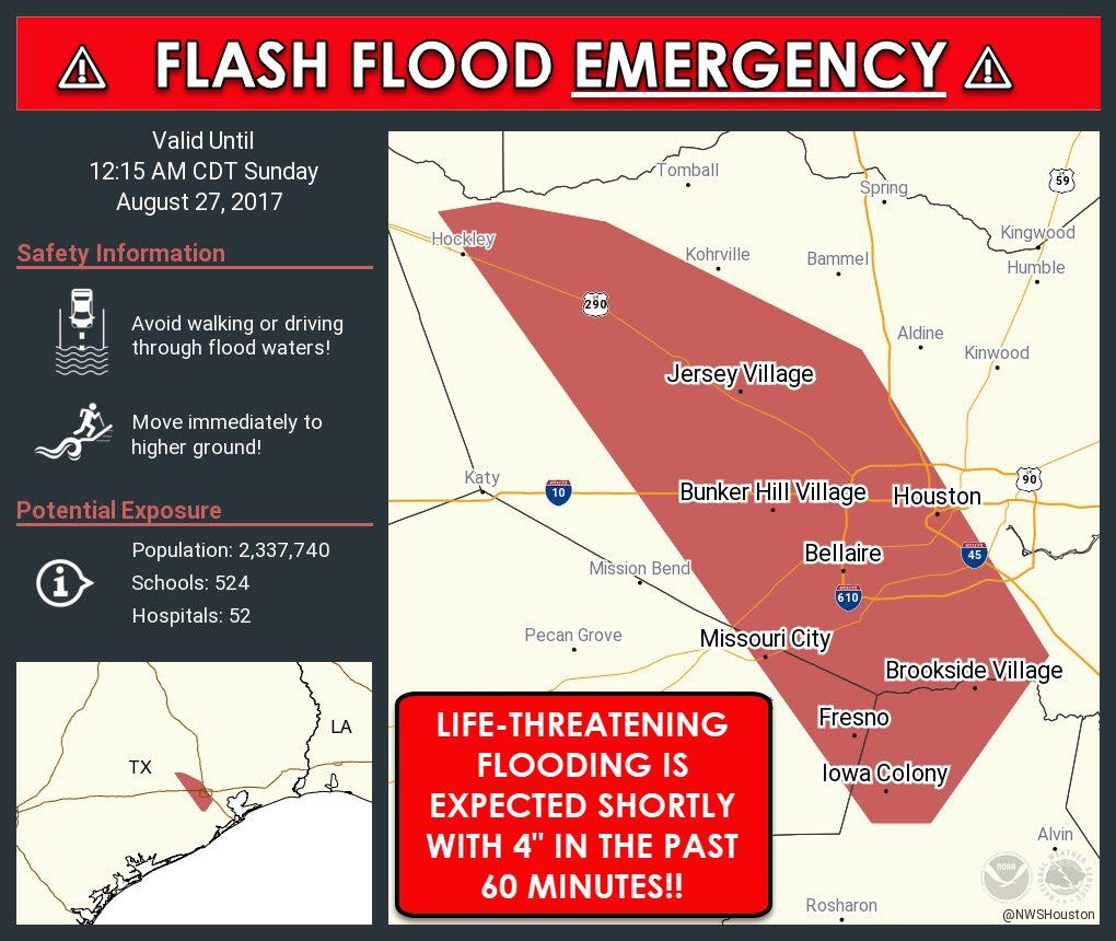
...FLASH FLOOD EMERGENCY FOR West Central Harris, Eastern Fort Bend and
Northern Brazoria counties...

The National Weather Service in League City has issued a

* Flash Flood Warning for...
  East central Fort Bend County in southeastern Texas...
  Northern Brazoria County in southeastern Texas...
  Central Harris County in southeastern Texas...

* Until 1215 AM CDT.

* At 921 PM CDT, Doppler radar indicated heavy rain across the
  warned area. 4 to 8 inches of rain have fallen. Rainfall rates of
  3 to 4 inches per hour are occuring with this very slow moving
  line of storms. Flash flooding is already occurring. Water rescues
  are ongoing.

  This is a FLASH FLOOD EMERGENCY for west central Harris county
  eastern Fort Bend and northern Brazoria counties. This is a
  PARTICULARLY DANGEROUS SITUATION. SEEK HIGHER GROUND NOW!

* Some locations that will experience flooding include...
  Pearland, northeastern Missouri City, Stafford, Bellaire, West
  University Place, Jersey Village, northwestern Manvel, Hunters
  Creek Village, Bunker Hill Village, Piney Point Village, Midtown
  Houston, Downtown Houston, Greenway / Upper Kirby Area, Spring
  Branch North, Greater Heights, Fresno, Neartown / Montrose, Greater
  Eastwood, Near Northside Houston and Greater Hobby Area.
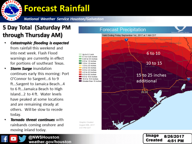
If you are in southeast Texas and have been lucky enough to miss much of the rainfall last night and today…just wait. There will be more on the way…several rounds of heavy rain…as Harvey will be hanging around well into the week ahead. In addition to tonight’s round of heavy rainfall and flooding, we’ll also continue to see the chance for tornados into the overnight hours with additional spin-ups possible. The greatest threat for tornadoes this evening will be within the heavy band of rain currently moving north up along the I-45 corridor. Once we get into the overnight hours, it’s likely we’ll see this focused area of very heavy rainfall expand and encompass more of the Houston/Galveston area plus surrounding communities dumping a good 3-6+ inches before sunrise tomorrow.
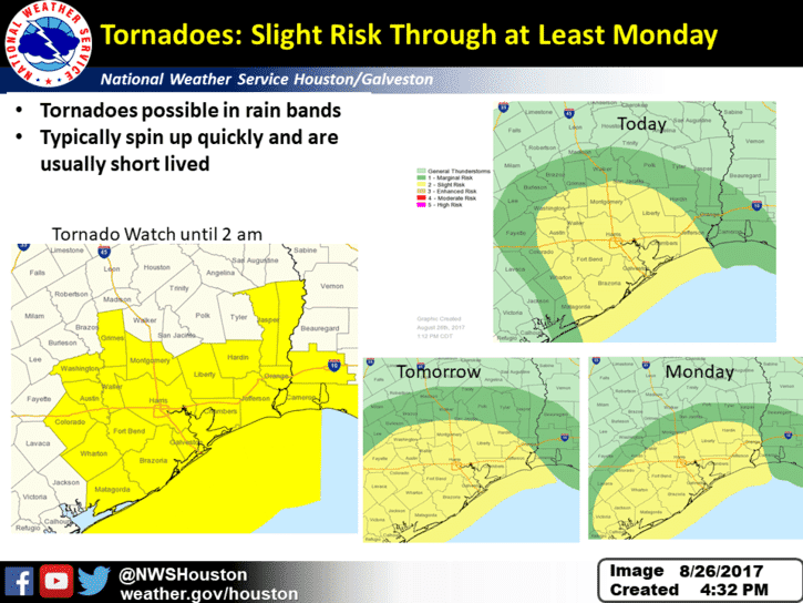
A similar scenario will play out tomorrow and into next week as well as heavy bands of rain continue to circle the outskirts of Harvey’s remnants until he moves out of the area. Quick tornadic spin-ups will also continue to be a threat…the location of which will be depend on where the strongest feeder bands of rain set up each day. The Storm Prediction Center keeps a Slight Risk across parts of southeast Texas through Monday to cover both the continued threat for tornados and strong storms embedded within the feeder bands that will continue to move north off the gulf. Residents of southeast Texas need to have a way to receive weather warnings each day and night until Harvey finally moves out of the area by late next week.


0 Comments