
Major Hurricane Harvey continues to produce devastating winds over 115 MPH including Rockport, Woodsboro, Lamar, Ingleside, Aransas Pass, Gregory, Bayside, Quintana, Palm Harbor, Key Allegro, Copano Village, Bonnie View, Holiday Beach and Fulton. Maximum sustained winds have decreased to 125 MPH, but Harvey is weakening very slowly as it moves slowly to the northwest at 6 MPH. Devastating major hurricane force winds will continue in the aforementioned cities through 3 to 4 AM – with the exception of those who end up in the eye. If you do end up in the eye keep in mind very strong winds will return from the different direction once the eye clears your location. Life-threatening storm surge will continue along the Middle Texas and Southeast Texas coast through the morning. Also – we’re watching several tornadic thunderstorms just west/southwest of the Houston metro. These may impact Rosenberg to Richmond to Sugar Land by 2 AM. Follow our twitter account for rapid-fire updates (link is below this post on mobile phones, right sidebar on desktop screen resolutions).
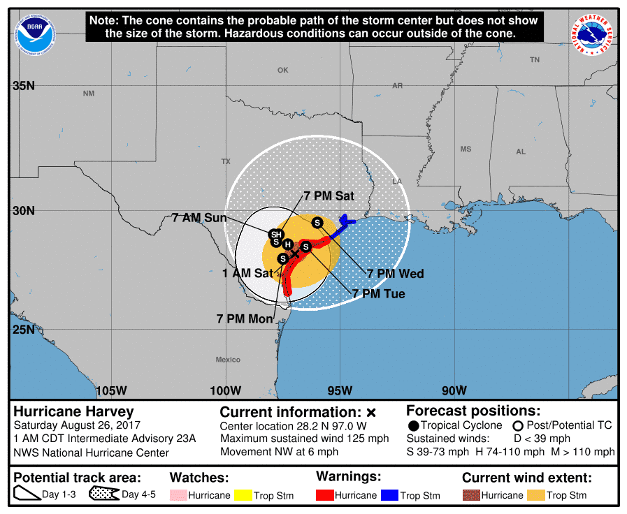
Hurricane Harvey Intermediate Advisory Number 23A
NWS National Hurricane Center Miami FL AL092017
100 AM CDT Sat Aug 26 2017
…HARVEY MAKES A SECOND LANDFALL ON THE NORTHEASTERN SHORE OF
COPANO BAY…
SUMMARY OF 100 AM CDT…0600 UTC…INFORMATION
———————————————-
LOCATION…28.2N 97.0W
ABOUT 5 MI…10 KM N OF ROCKPORT TEXAS
ABOUT 45 MI…75 KM S OF VICTORIA TEXAS
MAXIMUM SUSTAINED WINDS…125 MPH…205 KM/H
PRESENT MOVEMENT…NW OR 325 DEGREES AT 6 MPH…9 KM/H
MINIMUM CENTRAL PRESSURE…942 MB…27.82 INCHES
WATCHES AND WARNINGS
——————–
CHANGES WITH THIS ADVISORY:
None.
SUMMARY OF WATCHES AND WARNINGS IN EFFECT:
A Storm Surge Warning is in effect for…
* Port Mansfield to High Island Texas
A Hurricane Warning is in effect for…
* Port Mansfield to Sargent Texas
A Tropical Storm Warning is in effect for…
* North of Sargent to High Island Texas
A Storm Surge Warning means there is a danger of life-threatening
inundation from rising water moving inland from the coastline in the
indicated locations. For a depiction of areas at risk, please see
the National Weather Service Storm Surge Watch/Warning Graphic,
available at hurricanes.gov. This is a life-threatening situation.
A Hurricane Warning means that hurricane conditions are expected
somewhere within the warning area. Preparations to protect life and
property should already be complete.
Interests in southwestern Louisiana should continue to monitor the
progress of this system.
For storm information specific to your area, including possible
inland watches and warnings, please monitor products issued by your
local National Weather Service forecast office.
DISCUSSION AND 48-HOUR OUTLOOK
——————————
At 100 AM CDT (0600 UTC), the eye of Hurricane Harvey was located
near latitude 28.2 North, longitude 97.0 West. Harvey has made a
second landfall along the northeastern shore of Copano Bay, Texas.
Harvey is moving toward the northwest near 6 mph (9 km/h). The
hurricane is expected to slow down further during the next day or
so, and it will meander over southeastern Texas through the middle
of next week.
Maximum sustained winds have decreased to near 125 mph (205 km/h)
with higher gusts. Harvey is a category 3 hurricane on the
Saffir-Simpson Hurricane Wind Scale. Additional weakening is
forecast during the next 48 hours while the center of Harvey is over
southeastern Texas.
Hurricane-force winds extend outward up to 40 miles (65 km) from
the center, and tropical-storm-force winds extend outward up to 140
miles (220 km). A Texas Coastal Ocean Observing Network station at
the Aransas Wildlife Refuge recently measured sustained hurricane-
force winds of 74 mph (119 km/h) and a wind gust to 98 mph (157
km/h).
A National Ocean Service tide gauge at Port Lavaca, Texas, recently
reported a water level of 5.9 ft above Mean Higher High Water.
The estimated minimum central pressure is 942 mb (27.82 inches).
HAZARDS AFFECTING LAND
———————-
RAINFALL: Harvey is expected to produce total rain accumulations of
15 to 30 inches and isolated maximum amounts of 40 inches over the
middle and upper Texas coast through next Wednesday. During the same
time period Harvey is expected to produce total rain accumulations
of 5 to 15 inches in far south Texas and the Texas Hill Country over
through southwest and central Louisiana. Rainfall of this magnitude
will cause catastrophic and life-threatening flooding.
STORM SURGE: The combination of a dangerous storm surge and the
tide will cause normally dry areas near the coast to be flooded by
rising waters moving inland from the shoreline. The water is
expected to reach the following heights above ground if the peak
surge occurs at the time of high tide…
Port Aransas to Port O’Connor…9 to 13 ft
Port O’Connor to Sargent…6 to 9 ft
N Entrance Padre Island Natl Seashore to Port Aransas…5 to 8 ft
Sargent to Jamaica Beach…4 to 6 ft
Port Mansfield to N Entrance Padre Island Natl Seashore…3 to 5 ft
Jamaica Beach to High Island…2 to 4 ft
Mouth of the Rio Grande to Port Mansfield…1 to 3 ft
High Island to Morgan City…1 to 3 ft
The deepest water will occur along the immediate coast near and to
the northeast of the landfall location, where the surge will be
accompanied by large and destructive waves. Surge-related flooding
depends on the relative timing of the surge and the tidal cycle, and
can vary greatly over short distances. For information specific to
your area, please see products issued by your local National Weather
Service forecast office.
WIND: Hurricane conditions are occuring along portions of the
middle Texas coast within the hurricane warning area and are
spreading inland as the eye continues to move farther onshore.
Tropical storm conditions are occurring in other portions of the
hurricane and tropical storm warning areas. Tropical storm
conditions are likely to persist along portions of the coast through
at least Sunday.
SURF: Swells generated by Harvey are affecting the Texas,
Louisiana, and northeast Mexico coasts. These swells are likely to
cause life-threatening surf and rip current conditions. Please
consult products from your local weather office.
TORNADOES: Tornadoes are possible through Saturday near the middle
and upper Texas coast into far southwest Louisiana.


0 Comments