
Hurricane Harvey is now 100 miles southeast of Corpus Christi at noon. Harvey is expected to continue to move northwest today and will make landfall along the Middle Texas Coast late tonight. A hurricane hunter aircraft that just penetrated Harvey’s eye indicates the pressure may still be falling – which means the system is organizing. Surface winds have not yet increased past 110 MPH – fairly low for a ~945 millibar hurricane. We may see those winds catch back up to the pressure drop later today as an eyewall replacement cycle is completing. We expect Harvey will attain category 3 major hurricane status before landfall tonight. The time to evacuate from areas ordered to evacuate is pretty much over. If you are going to leave – do it now. A life-threatening storm surge up to 12 feet above ground level surge is expected from the north entrance of Padre Island National Seashore to Sargent. A storm surge of 5 to 8 feet above ground level is expected from Sargent to Jamaica Beach – and a 5 to 7-foot storm surge above ground level from Port Mansfield to north entrance of Padre Island National Seashore. Devastating wind damage is possible where Harvey makes landfall in the Middle Coast tonight – with the worst impacts in the northeastern eyewall. Tornadoes will be possible in the outer feeder bands of Harvey in Southeast Texas and the Coastal Plains this afternoon and this evening. After landfall Harvey will stall out this weekend – bringing a historic and catastrophic flooding event to parts of South-Central Texas, Coastal Plains, and Southeast Texas. It may move back into the Gulf of Mexico around Monday of next week – strengthening and moving back ashore for a second time in far Southeast Texas on Wednesday. We’ll deal with that possibility down the road.

Hurricane Harvey Tropical Cyclone Update
NWS National Hurricane Center Miami FL AL092017
1200 PM CDT Fri Aug 25 2017
…12 PM CDT POSITION ESTIMATE…
…SUSTAINED TROPICAL-STORM-FORCE WINDS HAVE REACHED THE MIDDLE
TEXAS COAST…
A sustained wind of 43 mph (69 km/h) and a wind gust to 48 mph (78
km/h) were recently reported at the Bob Hall Pier near Corpus
Christi, Texas.
A sustained wind of 49 mph (79 km/h) and a wind gust to 58 mph (94
km/h) were recently reported by NOAA buoy 42020, located about 40
miles off the coast of Texas.
NOAA tide gauges near Corpus Christi and Port Aransas indicate
storm surge inundation of 1 to 2 ft is already occurring.
SUMMARY OF 1200 PM CDT…1700 UTC…INFORMATION
———————————————-
LOCATION…26.9N 96.2W
ABOUT 100 MI…160 KM SE OF CORPUS CHRISTI TEXAS
ABOUT 105 MI…170 KM S OF PORT OCONNOR TEXAS
MAXIMUM SUSTAINED WINDS…110 MPH…175 KM/H
PRESENT MOVEMENT…NW OR 315 DEGREES AT 10 MPH…17 KM/H
MINIMUM CENTRAL PRESSURE…947 MB…27.97 INCHES
Key Messages:
1. Harvey is expected to be a major hurricane when it makes landfall
tonight, bringing life-threatening storm surge, rainfall, and wind
hazards to portions of the Texas coast. Preparations should be
rushed to completion in the warning areas as tropical-storm-force
winds are arriving on the coast, and conditions will continue to
deteriorate through the rest of today and tonight.
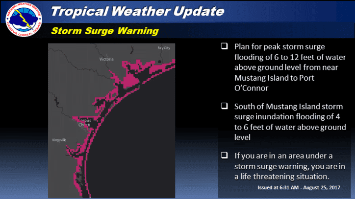
2. A Storm Surge Warning is in effect for much of the Texas coast.
Life-threatening storm surge flooding could reach heights of 6 to 12
feet above ground level at the coast between the north entrance of
the Padre Island National Seashore and Sargent. For a depiction of
areas at risk, see the Storm Surge Watch/Warning Graphic at
hurricanes.gov. Due to the slow motion of Harvey and a prolonged
period of onshore flow, water levels will remain elevated for
several days.
3. Catastrophic and life-threatening flooding is expected across the
middle and upper Texas coast from heavy rainfall of 15 to 25 inches,
with isolated amounts as high as 35 inches, through Wednesday.
Please refer to products from your local National Weather Service
office and the NOAA Weather Prediction Center for more information
on the flooding hazard.
4. The Potential Storm Surge Flooding Map is available on the NHC
website. This product depicts a reasonable worst-case scenario –
the amount of inundation that has a 10 percent chance of being
exceeded at each individual location. This map best represents
the flooding potential in those locations within the watch and
warning areas.
The Hurricane Watch south of Port Mansfield Texas to the Mouth of
the Rio Grande has been discontinued.
SUMMARY OF WATCHES AND WARNINGS IN EFFECT:
A Storm Surge Warning is in effect for…
* Port Mansfield to High Island Texas
A Storm Surge Watch is in effect for…
* South of Port Mansfield Texas to the Mouth of the Rio Grande
A Hurricane Warning is in effect for…
* Port Mansfield to Sargent Texas
A Tropical Storm Warning is in effect for…
* North of Sargent to High Island Texas
* South of Port Mansfield Texas to the Mouth of the Rio Grande
A Tropical Storm Watch is in effect for…
* South of the Mouth of the Rio Grande to Boca de Catan Mexico
A Storm Surge Warning means there is a danger of life-threatening
inundation from rising water moving inland from the coastline in the
indicated locations. For a depiction of areas at risk, please see
the National Weather Service Storm Surge Watch/Warning Graphic,
available at hurricanes.gov. This is a life-threatening situation.
Persons located within these areas should take all necessary actions
to protect life and property from rising water and the potential for
other dangerous conditions. Promptly follow evacuation and other
instructions from local officials.
A Hurricane Warning means that hurricane conditions are expected
somewhere within the warning area, in this case within the next 12
to 24 hours. Preparations to protect life and property should be
rushed to completion.
A Storm Surge Watch means there is a possibility of life-
threatening inundation from rising water moving inland from the
coastline in the indicated locations.
Interests in southwestern Louisiana should continue to monitor the
progress of this system.
HAZARDS AFFECTING LAND
———————-

RAINFALL: Harvey is expected to produce total rain accumulations
of 15 to 25 inches and isolated maximum amounts of 35 inches over
the middle and upper Texas coast through next Wednesday. During
the same time period Harvey is expected to produce total rain
accumulations of 5 to 15 inches in far south Texas and the Texas
Hill Country over through southwest and central Louisiana. Rainfall
of this magnitude will cause catastrophic and life-threatening
flooding.
STORM SURGE: The combination of a dangerous storm surge and the
tide will cause normally dry areas near the coast to be flooded by
rising waters moving inland from the shoreline. The water is
expected to reach the following heights above ground if the peak
surge occurs at the time of high tide…
N Entrance Padre Island Natl Seashore to Sargent…6 to 12 ft
Sargent to Jamaica Beach…5 to 8 ft
Port Mansfield to N Entrance Padre Island Natl Seashore…5 to 7 ft
Jamaica Beach to High Island…2 to 4 ft
Mouth of the Rio Grande to Port Mansfield…2 to 4 ft
High Island to Morgan City…1 to 3 ft
The deepest water will occur along the immediate coast near and to
the northeast of the landfall location, where the surge will be
accompanied by large and destructive waves. Surge-related flooding
depends on the relative timing of the surge and the tidal cycle, and
can vary greatly over short distances. For information specific to
your area, please see products issued by your local National Weather
Service forecast office.
WIND: All last-minute preparations should be rushed to completion
since tropical storm conditions are likely just beginning in
portions of the hurricane and tropical storm warning areas.
Hurricane conditions are likely to begin within the hurricane
warning area later today or tonight. Tropical storm conditions are
likely to persist along portions of the coast through at least
Sunday.
SURF: Swells generated by Harvey are affecting the Texas,
Louisiana, and northeast Mexico coasts. These swells are likely to
cause life-threatening surf and rip current conditions. Please
consult products from your local weather office.

TORNADOES: A few tornadoes are possible later today through
Saturday near the middle and upper Texas coast.


0 Comments