
Tropical Depression Harvey remains disorganized over the southern Gulf of Mexico this evening. Hurricane hunters arrived around 7 PM and confirm the system’s winds have not increased. However, surface pressures are slowly falling. An interesting tidbit was they found that the center of Harvey had reformed further east – not uncommon for a disorganized tropical cyclone. That relocation means most of this evening’s weather models are using data saying the center is about 30-40 miles west of its new location. That could cause a slight northward shift in new model guidance Thursday morning, but we don’t expect any dramatic shifts. It also hasn’t moved much today, resulting in the forecast landfall time to be pushed back to late Friday/early Saturday.
Harvey will likely continue to slowly organize tonight and Thursday morning. It should become a tropical storm later tonight or on Thursday. After that point and into Friday conditions will favor an accelerated pace for strengthening. Harvey is expected to be a category 1 hurricane when it makes landfall very late Friday night or early Saturday morning. Coastal impacts will likely begin Friday afternoon, although increased surf will be felt as soon as tomorrow.
After landfall Harvey will likely drift across South Texas through the weekend and into early next week. There is the potential for one to two feet of rain in South Texas, the Coastal Plains, Middle Coast, and Southeast Texas. The heaviest rains in Southeast Texas may actually hold off until the second half of this weekend, but timing will all depend on Harvey’s eventual track both while in the Gulf and after landfall. Concern over a life-threatening flood event remains the primary risk with Harvey with additional risks including storm surge, isolated tornadoes, and damaging winds. Please see the full National Hurricane Center update below for the latest information. 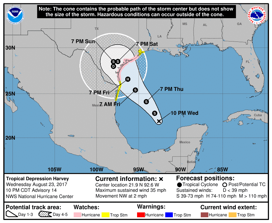
Tropical Depression Harvey Advisory Number 14
NWS National Hurricane Center Miami FL AL092017
1000 PM CDT Wed Aug 23 2017
…HARVEY DRIFTING ERRATICALLY NORTHWESTWARD AS A TROPICAL
DEPRESSION…
SUMMARY OF 1000 PM CDT…0300 UTC…INFORMATION
———————————————–
LOCATION…21.9N 92.6W
ABOUT 510 MI…815 KM SSE OF PORT OCONNOR TEXAS
ABOUT 445 MI…715 KM SE OF PORT MANSFIELD TEXAS
MAXIMUM SUSTAINED WINDS…35 MPH…55 KM/H
PRESENT MOVEMENT…NW OR 325 DEGREES AT 2 MPH…4 KM/H
MINIMUM CENTRAL PRESSURE…1002 MB…29.59 INCHES
WATCHES AND WARNINGS
——————–
CHANGES WITH THIS ADVISORY:
None.
SUMMARY OF WATCHES AND WARNINGS IN EFFECT:
A Storm Surge Watch is in effect for…
* Port Mansfield to High Island
A Hurricane Watch is in effect for…
* North of Port Mansfield to San Luis Pass
A Tropical Storm Watch is in effect for…
* Boca De Catan Mexico to Port Mansfield Texas
* North of San Luis Pass to High Island
A Storm Surge Watch means there is a possibility of life-
threatening inundation, from rising water moving inland from the
coastline, in the indicated locations during the next 48 hours.
For a depiction of areas at risk, please see the National Weather
Service Storm Surge Watch/Warning Graphic, available at
hurricanes.gov.
A Hurricane Watch means that hurricane conditions are possible
within the watch area. A watch is typically issued 48 hours
before the anticipated first occurrence of tropical-storm-force
winds, conditions that make outside preparations difficult or
dangerous.
A Tropical Storm Watch means that tropical storm conditions are
possible within the watch area, generally within 48 hours.
Warnings will likely be required for portions of the watch area
Thursday morning. In addition, interests in southwestern
Louisiana should continue to monitor the progress of this system.
For storm information specific to your area in the United
States, including possible inland watches and warnings, please
monitor products issued by your local National Weather Service
forecast office. For storm information specific to your area outside
the United States, please monitor products issued by your national
meteorological service.
DISCUSSION AND 48-HOUR OUTLOOK
At 1000 PM CDT (0300 UTC), the center of Tropical Depression Harvey
was located near latitude 21.9 North, longitude 92.6 West. The
depression is moving toward the northwest near 2 mph (4 km/h). A
track toward the northwest or north-northwest at a faster forward
speed is expected for the next 48 hours. On the forecast track,
Harvey should be approaching the Texas coast late Friday or Friday
night.
Reports from an Air Force Reserve Hurricane Hunter aircraft indicate
that maximum sustained winds remain near 35 mph (55 km/h) with
higher gusts. Some strengthening is forecast during the next
48 hours, and Harvey could become a tropical storm later tonight or
Thursday and a hurricane Friday or Friday night.
The latest minimum central pressure reported by the Hurricane Hunter
is 1002 mb (29.59 inches).
HAZARDS AFFECTING LAND
RAINFALL

Harvey is expected to produce total rain accumulations of
10 to 15 inches and isolated maximum amounts of 20 inches over the
Texas coast and southwest Louisiana through next Wednesday, with
heavy rainfall beginning Friday. During the same time period Harvey
is expected to produce total rain accumulations of 3 to 9 inches
along its outer radius including parts of south, central, and
eastern Texas and the lower Mississippi Valley. Rainfall from Harvey
may cause life-threatening flooding.
STORM SURGE:
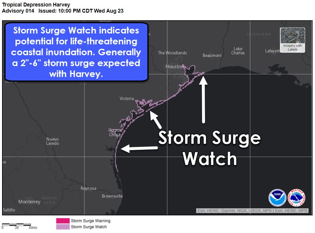
The combination of a dangerous storm surge and the
tide will cause normally dry areas near the coast to be flooded by
rising waters moving inland from the shoreline. The water is
expected to reach the following heights above ground if the peak
surge occurs at the time of high tide…
Port Mansfield to High Island…4 to 6 ft
The deepest water will occur along the immediate coast near and to
the northeast of the landfall location, where the surge will be
accompanied by large and destructive waves. Surge-related flooding
depends on the relative timing of the surge and the tidal cycle, and
can vary greatly over short distances. For information specific to
your area, please see products issued by your local National Weather
Service forecast office.
WIND:
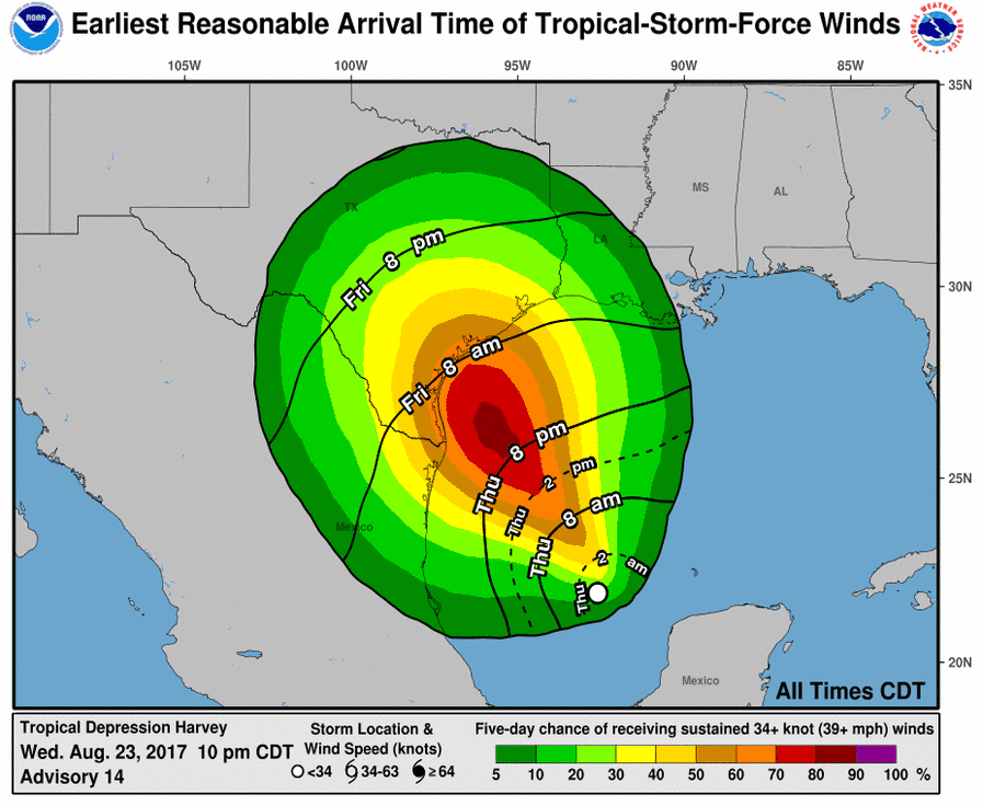
Hurricane conditions are possible within the hurricane watch
area late Friday or Friday night, with tropical storm conditions
possible by Friday.
SURF:
Swells generated by Harvey are likely to affect the Texas,
Louisiana, and northeast Mexico coasts by Friday. These swells are
likely to cause life-threatening surf and rip current conditions.
Please consult products from your local weather office.


0 Comments