
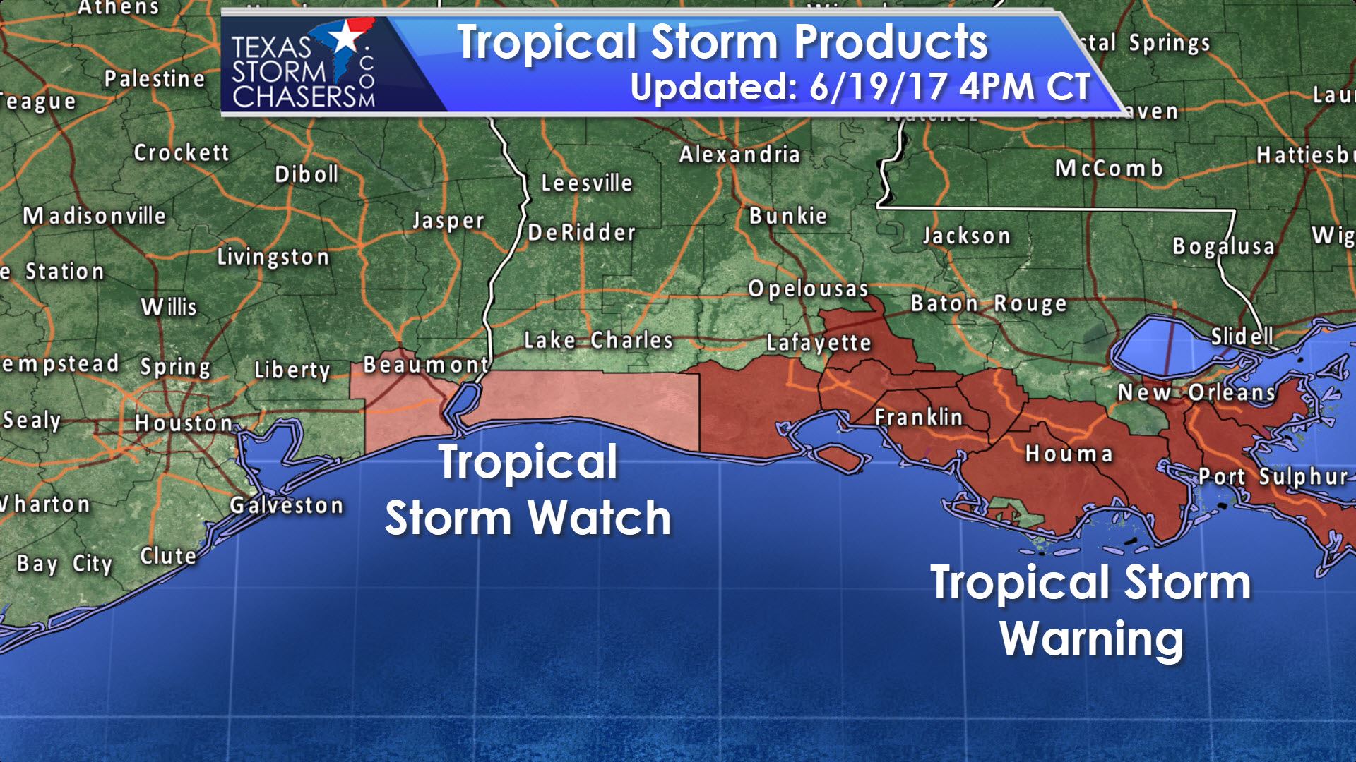
The National Hurricane Center has initiated advisories on Potential Tropical Cyclone Three – located 305 miles south of the mouth of the Mississippi River. These type of advisories are new and became operational for the 2017 hurricane season. Here is the explanation from the National Hurricane Center on this new policy. “The NWS now has the option to issue advisories, watches, and warnings for disturbances that are not yet a tropical cyclone, but which pose the threat of bringing tropical storm or hurricane conditions to land areas within 48 hours. Under the previous policy, this was not possible. These systems are known as Potential Tropical Cyclones in advisory products and are numbered from the same list as depressions. Because of the threat to the central Gulf Coast, advisories have been initiated on Potential Tropical Cyclone Three and the appropriate watches/warnings have been issued. Users should be aware that forecast uncertainty for disturbances is generally larger than for tropical cyclones, especially beyond 48-72 hours.” We do expect this system to officially become Tropical Storm Cindy by Tuesday as it moves north toward the Gulf Coast.

PTC #3 is expected to continue moving north to northwest at 9 MPH into Tuesday. Weather models are in general agreement that this system will make landfall anywhere from extreme Southeast Texas eastward to the west of New Orleans. This is unlikely to become a hurricane, so the threat of wind damage and storm surge will be low. Rough surf and dangerous swimming conditions are expected all along the Gulf Coast. The primary impact from future Cindy will be prolific rainfall amounts along and east of the track. Some locations could receive 5 to 10 inches, perhaps locally more. That would obviously result in a flooding threat. Isolated tornadoes can be expected to the east of the track as well. Should PTC #3 end up making landfall in Lousiana most impacts would likely remain east of Texas. If it tracks further west the potential for rainfall would increase substantially across parts of East and Southeast Texas. The Hurricane Hunters are investigating the low-level structure this afternoon while a NASA aircraft is collecting data from the upper-levels of the Gulf of Mexico. I’ll leave you with a statement for far Southeast Texas concerning their Tropical Storm Watch. This watch only includes far Southeast Texas. It does not include Galveston or any points further west.
JEFFERSON-
412 PM CDT MON JUN 19 2017
…TROPICAL STORM WATCH IN EFFECT…
A TROPICAL STORM WATCH MEANS TROPICAL STORM WIND CONDITIONS ARE
POSSIBLE SOMEWHERE WITHIN THIS AREA AND WITHIN THE NEXT 48 HOURS
* LOCATIONS AFFECTED
– BEAUMONT
– NEDERLAND
– PORT ARTHUR
– SABINE PASS
* WIND
– LATEST LOCAL FORECAST: BELOW TROPICAL STORM FORCE WIND
– PEAK WIND FORECAST: 10-20 MPH WITH GUSTS TO 25 MPH
– CURRENT THREAT TO LIFE AND PROPERTY: ELEVATED
– EMERGENCY PLANNING SHOULD INCLUDE A REASONABLE THREAT FOR
TROPICAL STORM FORCE WIND OF 39 TO 57 MPH.
– TO BE SAFE, PREPARE FOR THE POTENTIAL OF LIMITED WIND
IMPACTS. EFFORTS SHOULD NOW BE UNDERWAY TO SECURE ALL
PROPERTIES.
– HAZARDOUS WIND IS POSSIBLE. FAILURE TO ADEQUATELY SHELTER
MAY RESULT IN SERIOUS INJURY.
– POTENTIAL IMPACTS: LIMITED
– DAMAGE TO PORCHES, AWNINGS, CARPORTS, SHEDS, AND UNANCHORED
MOBILE HOMES. UNSECURED LIGHTWEIGHT OBJECTS BLOWN ABOUT.
– MANY LARGE TREE LIMBS BROKEN OFF. A FEW TREES SNAPPED OR
UPROOTED, BUT WITH GREATER NUMBERS IN PLACES WHERE TREES
ARE SHALLOW ROOTED. SOME FENCES AND ROADWAY SIGNS BLOWN
OVER.
– A FEW ROADS IMPASSABLE FROM DEBRIS, PARTICULARLY WITHIN
URBAN OR HEAVILY WOODED PLACES. HAZARDOUS DRIVING
CONDITIONS ON BRIDGES AND OTHER ELEVATED ROADWAYS.
– SCATTERED POWER AND COMMUNICATIONS OUTAGES.
* STORM SURGE
– NO STORM SURGE INUNDATION FORECAST
– CURRENT THREAT TO LIFE AND PROPERTY: NONE
– EMERGENCY PLANNING FOR THIS EVENT NEED NOT INCLUDE A THREAT
FOR STORM SURGE FLOODING. THE GROUND WILL REMAIN LARGELY
UNFLOODED FROM SURGE WATER OR ONLY HAVE SPOTS MINIMALLY
AFFECTED BY SURGE WATER ENCROACHMENT. SURF CONDITIONS MAY
STILL BE ROUGH WITH SOME BEACH EROSION. STRONGER THAN
NORMAL RIP CURRENTS MAY ALSO BE PRESENT.
– LITTLE TO NO PREPARATIONS NEEDED TO GUARD AGAINST STORM
SURGE FLOODING AT THIS TIME.
– ENSURE READINESS FOR THE NEXT STORM SURGE EVENT.
– POTENTIAL IMPACTS: LITTLE TO NONE
– LITTLE TO NO POTENTIAL IMPACTS FROM STORM SURGE FLOODING.
* FLOODING RAIN
– LATEST LOCAL FORECAST:
– PEAK RAINFALL AMOUNTS: ADDITIONAL 2-4 INCHES, WITH LOCALLY
HIGHER AMOUNTS
– CURRENT THREAT TO LIFE AND PROPERTY: NONE
– EMERGENCY PLANNING NEED NOT INCLUDE A THREAT FOR RAINFALL
FLOODING. LOCALLY HEAVY RAIN AND NUISANCE FLOODING MAY
STILL OCCUR.
– LITTLE TO NO PREPARATIONS NEEDED TO GUARD AGAINST EXCESSIVE
TROPICAL RAINFALL.
– ENSURE READINESS FOR THE NEXT TROPICAL RAINFALL EVENT.
– POTENTIAL IMPACTS: LITTLE TO NONE
– LITTLE TO NO POTENTIAL IMPACTS FROM FLOODING RAIN.
* TORNADO
– LATEST LOCAL FORECAST:
– SITUATION IS UNFAVORABLE FOR TORNADOES
– CURRENT THREAT TO LIFE AND PROPERTY: NONE
– EMERGENCY PLANNING NEED NOT INCLUDE A THREAT FOR TORNADOES.
SHOWERS AND THUNDERSTORMS WITH STRONG GUSTY WINDS MAY STILL
OCCUR.
– LITTLE TO NO PREPARATIONS NEEDED TO GUARD AGAINST TROPICAL
TORNADOES.
– ENSURE READINESS FOR THE NEXT TROPICAL TORNADO EVENT.
– POTENTIAL IMPACTS: LITTLE TO NONE
– LITTLE TO NO POTENTIAL IMPACTS FROM TORNADOES.


0 Comments