
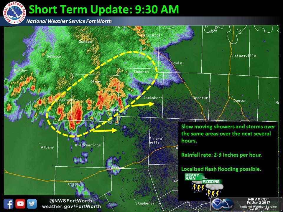
A series of subtle upper level impulses and summer-time moisture across Texas means continued scattered thunderstorm chances through the early part of next week. Yes, I’m afraid this means some of your weekend activities may be rained out. Like yesterday we’re going to see areas that get a boatload of rain while those a few miles away may only see sprinkles. That doesn’t even include the folks who don’t see a drop of rain at all. These summer-type events are hit/miss versus a ‘line’ which we can forecast more acutely and with better time estimates. A cluster of heavy rain is impacting parts of Northwest Texas and western North Texas. Two to five inches of rain has fallen around Throckmorton up to Lawton with various road closures. This cluster is hardly moving and a prime example of how we see areas of flooding with summer activity. Outflow produced by this cluster will probably help spark off additional thunderstorms further east and south this afternoon, although more scattered than the widespread rain ongoing in Northwest Texas. Any one of these popup storms may produce three inches of rain in an hour over a localized area. Widespread flooding is not expected, but if you end up under one of these heavy storms, you could easily have some minor flooding.
These subtle upper level impulses, which you can think of as a source of lift, will continue to track over Texas through the weekend. These are not easy to track. Those near the impulses will tend to see higher rain chances while areas around them may see some sinking of air – so rain chances would be a bit lower. Rain chances will tend to be 40 to 60 percent nearest to the impulses, perhaps a bit higher. While most locations will generally pick up less than an inch of rain, those who end up under heavier storms – or multiple rounds of storms – may experience several inches of rain and a threat for localized flooding. The highest rain chances will be from the mid-morning through late-afternoon hours. Those in closer proximity to these upper level impulses could see rain chances continue into the night time hours. I do think we are going to see localized flooding this weekend and if we see training storms set up we could see some big-time rain totals over a very localized area. Where exactly that would be? That isn’t something we can remotely guess at until it is within 6-12 hours thanks to this setup. Unlike a defined upper level storm system we’re dealing with lots of moisture and almost indiscernible areas of upper lift this weekend. Welcome to summer folks!


0 Comments