
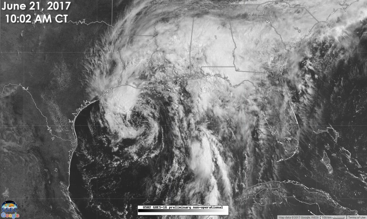
Tropical Storm Cindy is now located about 180 miles southeast of Galveston and is moving northwest at 10 MPH. Landfall is expected in far Southeast Texas or Southwest Lousiana late tonight or early Thursday morning. Cindy has weakened a tad overnight with maximum sustained winds now at 50 MPH with higher gusts. These highest winds are contained in a few thunderstorms well north of the center. This is not your classic-looking system with heavy rain wrapping around an eye or center. Strong wind shear and dry air are pushing the heaviest convection well to the north and east. The west and southern sections of Cindy contain little rain thanks to dry air. That is one sign of a disorganized tropical system. Yet several buoys in the northern Gulf have been measuring sustained tropical storm force winds, so while it may not be pretty looking, this is indeed a tropical storm with a defined low-level spin. Let’s dig into the details and talk about each specific hazard we may be facing in the next day and a half.
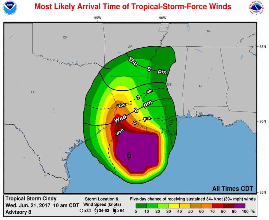
Wind Threat: A Tropical Storm Warning remains in effect from San Luis Pass east into southern Lousiana. I do believe the highest probability of experiencing wind gusts over 40 MPH will be in far Southeast Texas by this evening into Thursday morning. This shouldn’t be a big-time problem, but it will definitely be windy. Honestly, winds will probably be comparable to what you might see in the vicinity of a strong summer thunderstorm. Enough to notice, but probably not enough to cause much damage. Make sure you bring your outdoor chairs and trash cans indoors. I wouldn’t be shocked to see a trampoline or two go flying from High Island to Sabine Pass as stronger storms help bring the higher winds down to the surface later today.
Storm Surge: A one to three-foot storm surge is possible along the Southeast Texas coastline which may result in minor tidal flooding. What is much more noticeable is the rough surf and dangerous rip currents. Wave action is heightened across the entire Gulf of Mexico thanks to Cindy.
Tornado Threat: An isolated tornado cannot be ruled out in extreme Southeast or extreme East Texas tonight or Thursday as Cindy moves north and eventually northeast. The higher threat for a couple of tornadoes will be in Lousiana, Mississippi, and Alabama.
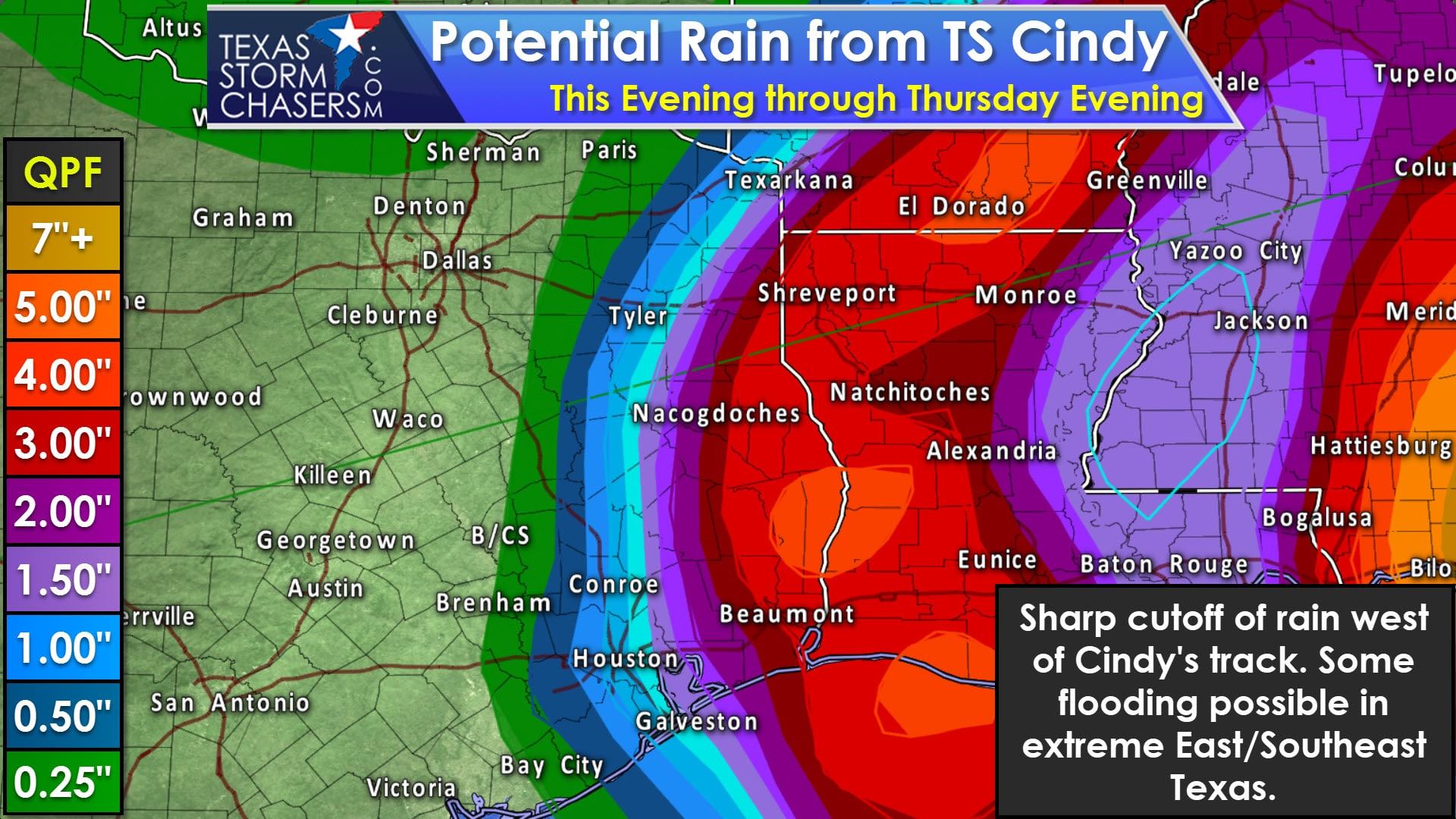
Heavy Rain and Flooding: Cindy has the potential of bringing a quick two to five inches of rain along and east of its track tonight and on Thursday. The best chance of those rain amounts in Texas will be across the far eastern sections of East and Southeast Texas. The western semi-circle of Cindy looks fairly dry with a sharp-cutoff in rain. We’ll likely see only a 25-40 mile difference between a trace of rain and several inches of rain. The highest relative chance for localized flooding will be east of a Liberty-Livingston-Henderson-Texarkana line. If Cindy tracks a tad further east that line would also be pushed east. Regardless the highest threat of very heavy rain and flooding will be along the Gulf Coast in Lousiana, Mississippi, and Alabama and their respective inland regions.
Timing: We could see a few showers start impacting the Southeast Texas coastline as soon as the afternoon hours. The best chance for rain will be as Cindy moves onshore and inland tonight and during the day Thursday. Rain chances will increase across far East Texas on Thursday as Cindy moves north and eventually turns northeast toward Arkansas. Without much rain on the western side of Cindy, we should see rain chances dwindling down by Thursday evening. I can’t rule out scattered storms along the coast on Friday, but you’ll certainly have better chances of nicer weather than you will tomorrow.
Here is the full 10 AM advisory from the National Hurricane Center on Cindy. An intermediate advisory will be issued at 1 PM CT with an update on the location and wind speed. The next full advisory with any forecast changes will be issued at 4 PM CT.
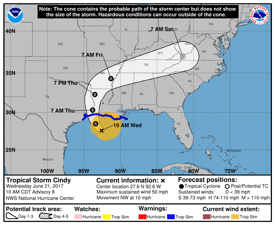
Tropical Storm Cindy Advisory Number 8
NWS National Hurricane Center Miami FL AL032017
1000 AM CDT Wed Jun 21 2017
…CINDY WEAKENS SLIGHTLY…
…HEAVY RAINFALL COULD PRODUCE LIFE-THREATENING FLASH FLOODING
ACROSS PORTIONS OF THE NORTHERN GULF COAST…
SUMMARY OF 1000 AM CDT…1500 UTC…INFORMATION
———————————————–
LOCATION…27.6N 92.6W
ABOUT 170 MI…270 KM SSW OF MORGAN CITY LOUISIANA
ABOUT 180 MI…285 KM SE OF GALVESTON TEXAS
MAXIMUM SUSTAINED WINDS…50 MPH…85 KM/H
PRESENT MOVEMENT…NW OR 310 DEGREES AT 10 MPH…17 KM/H
MINIMUM CENTRAL PRESSURE…996 MB…29.42 INCHES
WATCHES AND WARNINGS
——————–
CHANGES WITH THIS ADVISORY:
The Tropical Storm Warning is discontinued north and east of the
mouth of the Mississippi River, including Metropolitan New Orleans
and Lake Pontchartrain.
SUMMARY OF WATCHES AND WARNINGS IN EFFECT:
A Tropical Storm Warning is in effect for…
* San Luis Pass Texas to the mouth of the Mississippi River
A Tropical Storm Warning means that tropical storm conditions are
expected somewhere within the warning area, in this case within the
next 12 to 24 hours.
Interests elsewhere along the U.S. Gulf Coast from the central Texas
coast to the western Florida Panhandle should monitor the progress
of this system.
For storm information specific to your area, including possible
inland watches and warnings, please monitor products issued by your
local National Weather Service forecast office.
DISCUSSION AND 48-HOUR OUTLOOK
——————————
At 1000 AM CDT (1500 UTC), the center of Tropical Storm Cindy was
located near latitude 27.6 North, longitude 92.6 West. Cindy is
moving toward the northwest near 10 mph (17 km/h), and this motion
is expected to continue today. A turn toward the north-northwest
and then toward the north is expected tonight and Thursday. On
the forecast track, the center of Cindy will approach the coast of
southwest Louisiana and southeast Texas late today or tonight, and
move inland over southeastern Texas or southwestern Louisiana on
Thursday.
Surface observations and reports from an Air Force Reserve
Hurricane Hunter aircraft indicate that maximum sustained winds are
now near 50 mph (85 km/h) with higher gusts. Little change in
strength is expected before landfall, with weakening
expected thereafter.
Tropical-storm-force winds extend outward up to 205 miles (335 km)
mainly to the north and east of the center.
The minimum central pressure just reported by the Hurricane Hunter
aircraft is 996 mb (29.42 inches).
HAZARDS AFFECTING LAND
———————-
RAINFALL: Cindy is expected to produce total rain accumulations of
6 to 9 inches with isolated maximum amounts of 12 inches over
southeastern Louisiana, southern Mississippi, southern Alabama, and
western portions of the Florida Panhandle through Thursday. This
rainfall could cause life-threatening flash flooding in these areas.
Rainfall amounts of 3 to 5 inches with isolated maximum amounts of 7
inches can be expected farther west across western Louisiana and
eastern Texas through Thursday. Rainfall should spread
northeastward across Arkansas and into portions of the Tennessee and
Ohio Valleys through Friday, with total rain accumulations of 3 to 5
inches with locally higher amounts possible.
WIND: Tropical storm conditions should spread westward and
northward through the Tropical Storm Warning area today through
Thursday.
STORM SURGE: Inundation of 1 to 3 feet above ground level is
expected along the coast in portions of the Tropical Storm Warning
area. Inundation of 1 to 3 feet above ground level is also possible
elsewhere along the coast from southeastern Louisiana to the western
Florida Panhandle in areas of strong onshore winds.
TORNADOES: A few tornadoes are possible today through tonight from
the western Florida Panhandle across southwest Alabama, southern
Mississippi, and southern Louisiana.


0 Comments