
Wind Threat: A Tropical Storm Warning remains in effect from San Luis Pass east into southern Lousiana. I do believe the highest probability of experiencing wind gusts over 40 MPH will be in far Southeast Texas by this evening into Thursday morning. This shouldn’t be a big-time problem, but it will definitely be windy. Honestly, winds will probably be comparable to what you might see in the vicinity of a strong summer thunderstorm. Enough to notice, but probably not enough to cause much damage. Make sure you bring your outdoor chairs and trash cans indoors. I wouldn’t be shocked to see a trampoline or two go flying from High Island to Sabine Pass as stronger storms help bring the higher winds down to the surface later today.
Storm Surge: A one to three-foot storm surge is possible along the Southeast Texas coastline which may result in minor tidal flooding. What is much more noticeable is the rough surf and dangerous rip currents. Wave action is heightened across the entire Gulf of Mexico thanks to Cindy.
Tornado Threat: An isolated tornado cannot be ruled out in extreme Southeast or extreme East Texas tonight or Thursday as Cindy moves north and eventually northeast. The higher threat for a couple of tornadoes will be in Lousiana, Mississippi, and Alabama.
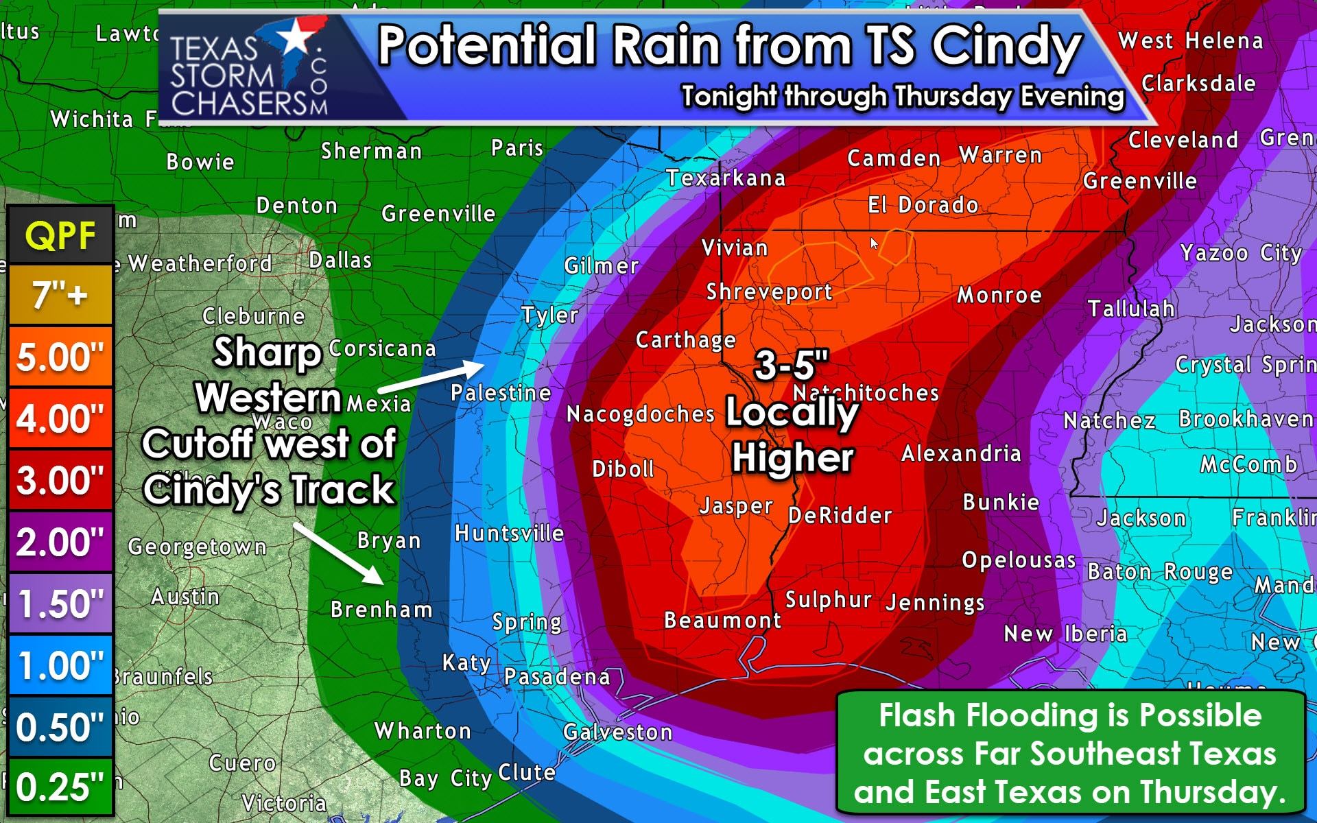
Heavy Rain and Flooding: Cindy has the potential of bringing a quick two to five inches of rain along and east of its track tonight and on Thursday. The best chance of those rain amounts in Texas will be across the far eastern sections of East and Southeast Texas. The western semi-circle of Cindy looks fairly dry with a sharp-cutoff in rain. We’ll likely see only a 25-40 mile difference between a trace of rain and several inches of rain. The highest relative chance for localized flooding will be east of a Liberty-Livingston-Henderson-Texarkana line. If Cindy tracks a tad further east that line would also be pushed east. Regardless the highest threat of very heavy rain and flooding will be along the Gulf Coast in Lousiana, Mississippi, and Alabama and their respective inland regions. Locally higher rain amounts are possible, and some locations could pick up these multi-inch rain amounts in a matter of two or three hours.
Timing: We could see a few showers start impacting the Southeast Texas coastline as soon as the late afternoon hours. The best chance for rain will be as Cindy moves onshore and inland tonight and during the day Thursday. Rain chances will increase across far East Texas on Thursday as Cindy moves north and eventually turns northeast toward Arkansas. Without much rain on the western side of Cindy, we should see rain chances dwindling down by Thursday evening. I can’t rule out scattered storms along the coast on Friday, but you’ll certainly have better chances of nicer weather than you will tomorrow.
Here is the full 4 PM advisory from the National Hurricane Center. We still anticipate Cindy to make landfall late tonight or early Thursday along the Southeast Texas coastline.
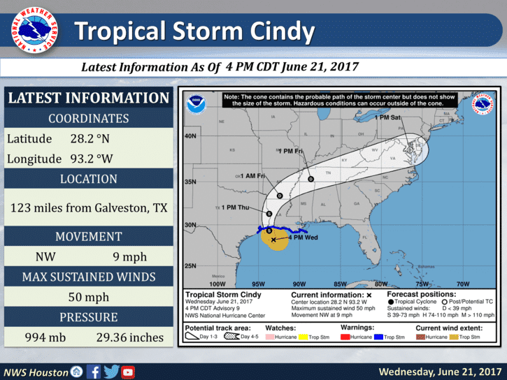
Tropical Storm Cindy Advisory Number 9
NWS National Hurricane Center Miami FL AL032017
400 PM CDT Wed Jun 21 2017
…HEAVY RAINFALL FROM CINDY AFFECTING THE NORTHERN GULF COAST…
…THESE RAINS COULD PRODUCE LIFE-THREATENING FLASH FLOODING…
SUMMARY OF 400 PM CDT…2100 UTC…INFORMATION
———————————————-
LOCATION…28.2N 93.2W
ABOUT 135 MI…215 KM S OF LAKE CHARLES LOUISIANA
ABOUT 125 MI…200 KM SE OF GALVESTON TEXAS
MAXIMUM SUSTAINED WINDS…50 MPH…85 KM/H
PRESENT MOVEMENT…NW OR 315 DEGREES AT 9 MPH…15 KM/H
MINIMUM CENTRAL PRESSURE…994 MB…29.36 INCHES
WATCHES AND WARNINGS
——————–
CHANGES WITH THIS ADVISORY:
None.
SUMMARY OF WATCHES AND WARNINGS IN EFFECT:
A Tropical Storm Warning is in effect for…
* San Luis Pass Texas to the mouth of the Mississippi River
A Tropical Storm Warning means that tropical storm conditions are
expected somewhere within the warning area, in this case within the
next 12 to 24 hours.
Interests elsewhere along the U.S. Gulf Coast from the central Texas
coast to the western Florida Panhandle should monitor the progress
of this system.
For storm information specific to your area, including possible
inland watches and warnings, please monitor products issued by your
local National Weather Service forecast office.
DISCUSSION AND 48-HOUR OUTLOOK
——————————
At 400 PM CDT (2100 UTC), the center of Tropical Storm Cindy was
located near latitude 28.2 North, longitude 93.2 West. Cindy is
moving toward the northwest near 9 mph (15 km/h). A turn toward the
north-northwest is expected tonight and Thursday, with a turn toward
the northeast expected on Friday. On the forecast track, the center
of Cindy will move inland over southeastern Texas or southwestern
Louisiana late tonight or early Thursday, then move near or over
extreme eastern Texas, western and northern Louisiana, and
southeastern Arkansas Thursday and Thursday night.
Maximum sustained winds are near 50 mph (85 km/h) with higher gusts.
Little change in strength is expected before landfall, with
weakening expected thereafter.
Tropical-storm-force winds extend outward up to 115 miles (185 km)
from the center.
The estimated minimum central pressure based on observations from
oil rigs near the center is 994 mb (29.36 inches).
HAZARDS AFFECTING LAND
———————-
RAINFALL: Cindy is expected to produce total rain accumulations of
6 to 9 inches with isolated maximum amounts up to 15 inches over
southeastern Louisiana, southern Mississippi, southern Alabama, and
western portions of the Florida Panhandle through Thursday night.
This rainfall could cause life-threatening flash flooding in these
areas.
Rainfall amounts of 3 to 5 inches with isolated maximum amounts of
7 inches can be expected farther west across western Louisiana and
eastern Texas through Thursday night. Rainfall should spread
northeastward across Arkansas and into portions of the Tennessee
and Ohio Valleys through Friday, with total rain accumulations of
3 to 5 inches with locally higher amounts possible.
WIND: Tropical storm conditions should spread westward and
northward through the Tropical Storm Warning area this afternoon
through Thursday.
STORM SURGE: Inundation of 1 to 3 feet above ground level is
expected along the coast in portions of the Tropical Storm Warning
area. Inundation of 1 to 3 feet above ground level is also possible
elsewhere along the coast from southeastern Louisiana to the western
Florida Panhandle in areas of strong onshore winds.
TORNADOES: A few tornadoes are possible into tonight from the far
western Florida Panhandle across southwestern Alabama, southern
Mississippi, and southern Louisiana.


0 Comments