
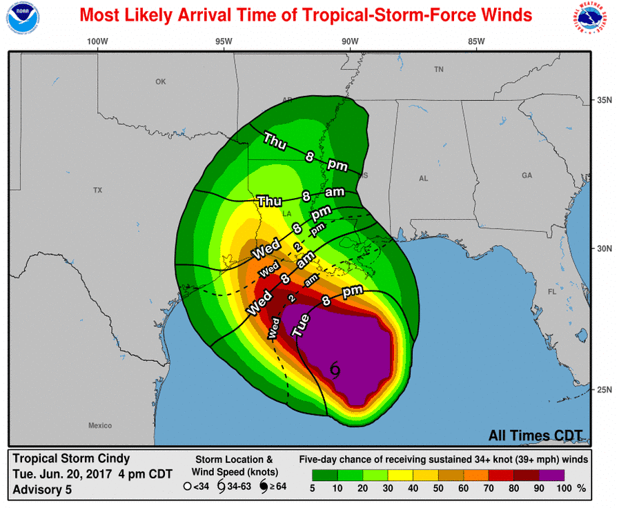
Tropical Storm Cindy remains stationary about 360 miles southeast of Galveston. Maximum sustained winds are near 45 MPH with higher gusts in thunderstorms about 100 miles north of the center. A general north/northwestward movement is expected tonight. Landfall should occur late Wednesday into early Thursday in far Southeast Texas to southwest Lousiana. Impacts from Cindy will be worst near and well to the east of the track. Flooding could be a threat over 500 miles east of the landfall location. This advisory from the National Hurricane Center has upgraded areas under the Tropical Storm Watch to a Tropical Storm Warning. A Tropical Storm Warning means winds over 40 MPH are possible within the next 24 hours. This warning runs from San Luis Pass into Lousiana. It includes Jamacia Beach, Galveston, Houston, Port Bolivar, High Island, Sabine Pass, Port Arthur, Beaumont, and Orange. The western edge of the precipitation and heavier rains will have a sharp cutoff. At this point, it looks like rain chances will tend to stay lower in D/FW as Cindy should pass well to the east. 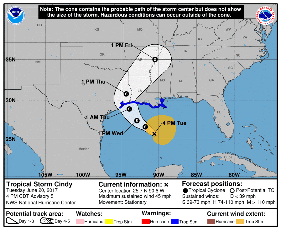
Storm Surge Potential: A 1 to 3-foot storm surge is possible along and east of the center’s landfall location. This may result in tidal flooding. Expect substantial waves on top of the surge. Dangerous swimming conditions are expected all along the Gulf Coast with severe riptides.
Tornado Risk: An isolated tornado is possible across far Southeast Texas, but the higher risk will probably be further east into Lousiana with any outer feeder bands on Wednesday.
Wind Risk: Tropical storm force winds are possible along the Southeast Texas coast from Sabine Pass and points east on Wednesday. Winds will be stronger along the coast and offshore. Sustained winds onshore in places like Houston should be lower, but may still see gusts approaching 40 MPH Wednesday night into Thursday morning.

Flooding Risk: A significant and potentially life-threatening flood event is forecast in portions of Lousiana, Mississippi, Alabama, and Florida Panhandle coastal regions. Rainfall amounts up to a foot are expected and there have already been flooding issues today. At this time rainfall amounts across Southeast Texas and portions of East Texas are forecast to range from 3 to 9 inches. Some higher amounts may occur. A significant flood threat may develop Wednesday Night and into Thursday as Cindy moves onshore. The heavy rainfall threat will spread northward as copious amounts of moisture advect inland. While Cindy will quickly weaken after moving onshore, the heavy rainfall threat will continue well inland across East Texas on Thursday.
Tropical Storm Cindy Advisory Number 5
NWS National Hurricane Center Miami FL AL032017
400 PM CDT Tue Jun 20 2017
…CINDY MEANDERING OVER THE CENTRAL GULF…
…HEAVY RAINFALL COULD PRODUCE LIFE-THREATENING FLASH FLOODING
ACROSS PORTIONS OF THE NORTHERN GULF COAST…
SUMMARY OF 400 PM CDT…2100 UTC…INFORMATION
———————————————-
LOCATION…25.7N 90.6W
ABOUT 280 MI…450 KM S OF MORGAN CITY LOUISIANA
ABOUT 360 MI…575 KM SE OF GALVESTON TEXAS
MAXIMUM SUSTAINED WINDS…45 MPH…75 KM/H
PRESENT MOVEMENT…STATIONARY
MINIMUM CENTRAL PRESSURE…999 MB…29.50 INCHES
WATCHES AND WARNINGS
——————–
CHANGES WITH THIS ADVISORY:
The Tropical Storm Warning has been extended westward to San Luis
Pass, Texas.
SUMMARY OF WATCHES AND WARNINGS IN EFFECT:
A Tropical Storm Warning is in effect for…
* San Luis Pass to the Mouth of the Pearl River
A Tropical Storm Warning means that tropical storm conditions are
expected somewhere within the warning area, in this case within the
next 24 to 36 hours.
Interests elsewhere along the U.S. Gulf Coast from the central Texas
coast to the western Florida Panhandle should monitor the progress
of this system.
For storm information specific to your area, including possible
inland watches and warnings, please monitor products issued by your
local National Weather Service forecast office.
DISCUSSION AND 48-HOUR OUTLOOK
——————————
At 400 PM CDT (2100 UTC), the center of Tropical Storm Cindy was
located near latitude 25.7 North, longitude 90.6 West. Cindy has
been nearly stationary for the past several hours, but a
northwestward motion is expected to resume tonight and continue
through Wednesday. A turn toward the north-northwest and then toward
the north is expected Wednesday night and early Thursday. On the
forecast track, the center of Cindy will approach the coast of
southwest Louisiana and southeast Texas late Wednesday and Wednesday
night, and move inland over southeastern Texas on Thursday.
Maximum sustained winds are near 45 mph (75 km/h) with higher gusts.
Some slight strengthening is expected during the next 24 hours.
Tropical-storm-force winds extend outward up to 205 miles (335 km)
from the center, mainly to the north and east of the center.
The estimated minimum central pressure is 999 mb (29.50 inches).
HAZARDS AFFECTING LAND
———————-
RAINFALL: Cindy is expected to produce total rain accumulations of
6 to 9 inches with isolated maximum amounts of 12 inches over
southeastern Louisiana, southern Mississippi, southern Alabama, and
the Florida Panhandle through Thursday. This rainfall could cause
life-threatening flash flooding in these areas.
Rainfall amounts of 3 to 5 inches with isolated maximum amounts of 6
inches can be expected farther west across southwest Louisiana into
southeast Texas through Thursday.
WIND: Tropical storm conditions are expected to first reach the
coast within the warning area later today and spread westward within
the warning area through early Thursday.
STORM SURGE: Inundation of 1 to 3 feet above ground level is
possible along the coast in portions of the Tropical Storm Warning
area.
TORNADOES: Isolated tornadoes are possible this evening and tonight
from south-central Louisiana to the western Florida Panhandle.


0 Comments