
Tropical Storm Cindy is 95 miles south/southeast of Port Arthur and is moving north/northwest at 7 MPH. Cindy is expected to make landfall near the Texas/Lousiana border early Thursday morning. Maximum sustained winds remain near 50 MPH in heavier thunderstorms on the northern side of the circulation. Little change in strength is expected until the system makes landfall – after which time weakening will commence. The primary concern with Cindy will be very heavy rainfall along and east of the track through Thursday night. Cindy will begin turning more to the north Thursday morning and eventually turn northeast exiting far east Texas by Thursday Night. Dangerous flash flooding is possible overnight in far Southeast Texas, including the Beaumont area. Strong winds are also expected in this area as Cindy approaches and makes landfall early Thursday. The threat for heavy rains will increase on Thursday across far East Texas. Most activity should be exiting Texas by late Thursday night. Remember, there will be a sharp cut-off in the rain west of the circulation center. That means there may not be much distance between no rain and flooding rains.
Tropical Storm Cindy Advisory Number 10
NWS National Hurricane Center Miami FL AL032017
1000 PM CDT Wed Jun 21 2017
…HEAVY RAINS AFFECTING PORTIONS OF THE NORTHERN GULF COAST…
…LIFE-THREATENING FLASH FLOODING POSSIBLE…
SUMMARY OF 1000 PM CDT…0300 UTC…INFORMATION
———————————————–
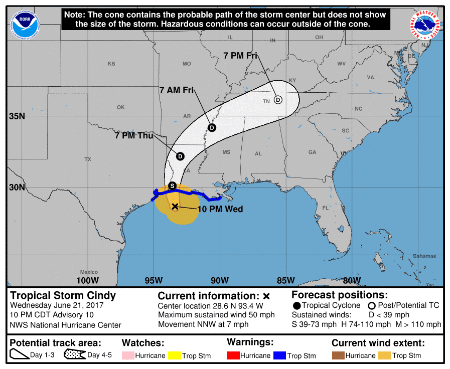
LOCATION…28.6N 93.4W
ABOUT 155 MI…245 KM WSW OF MORGAN CITY LOUISIANA
ABOUT 95 MI…150 KM SSE OF PORT ARTHUR TEXAS
MAXIMUM SUSTAINED WINDS…50 MPH…85 KM/H
PRESENT MOVEMENT…NNW OR 340 DEGREES AT 7 MPH…11 KM/H
MINIMUM CENTRAL PRESSURE…992 MB…29.30 INCHES
WATCHES AND WARNINGS
——————–
CHANGES WITH THIS ADVISORY:
The Tropical Storm Warning has been discontinued east of Grand
Isle, Louisiana.
SUMMARY OF WATCHES AND WARNINGS IN EFFECT:
A Tropical Storm Warning is in effect for…
* San Luis Pass Texas to Grand Isle
A Tropical Storm Warning means that tropical storm conditions are
expected somewhere within the warning area, in this case within the
next 12 hours.
Interests elsewhere along the U.S. Gulf Coast from the central Texas
coast to the western Florida Panhandle should monitor the progress
of this system.
For storm information specific to your area, including possible
inland watches and warnings, please monitor products issued by your
local National Weather Service forecast office.
DISCUSSION AND 48-HOUR OUTLOOK
——————————
At 1000 PM CDT (0300 UTC), the center of Tropical Storm Cindy was
located near latitude 28.6 North, longitude 93.4 West. Cindy is
moving toward the north-northwest near 7 mph (11 km/h). A turn
toward the north should occur by Thursday morning, with a turn
toward the northeast expected on Friday. On the forecast track,
the center of Cindy will move inland near the Louisiana-Texas border
early Thursday, then move across western and northern Louisiana and
into southeastern Arkansas Thursday night.
Maximum sustained winds are near 50 mph (85 km/h) with higher gusts.
Little change in strength is expected before landfall, with
weakening occurring thereafter.
Tropical-storm-force winds extend outward up to 115 miles (185 km)
from the center.
The estimated minimum central pressure based on recent observations
from oil rigs near the center is 992 mb (29.29 inches).
HAZARDS AFFECTING LAND
———————-
RAINFALL: Cindy is expected to produce total rain accumulations of
6 to 9 inches with isolated maximum amounts up to 15 inches over
southeastern Louisiana, southern Mississippi, southern Alabama, and
western portions of the Florida Panhandle through Thursday night.
This rainfall could cause life-threatening flash flooding in these
areas.
Rainfall amounts of 3 to 5 inches with isolated maximum amounts of
7 inches can be expected farther west across western Louisiana and
eastern Texas through Thursday night. Rainfall should spread
northeastward across Arkansas and into portions of the Tennessee
and Ohio Valleys through Friday, with total rain accumulations of
3 to 5 inches with locally higher amounts possible.
WIND: Tropical storm conditions should spread westward and
northward through the Tropical Storm Warning area through Thursday.
STORM SURGE: Inundation of 1 to 3 feet above ground level is
expected along the coast in portions of the Tropical Storm Warning
area. Inundation of 1 to 3 feet above ground level is also possible
elsewhere along the coast from southeastern Louisiana to the western
Florida Panhandle in areas of strong onshore winds.
TORNADOES: A few tornadoes are possible tonight from the far
western Florida Panhandle across southwestern Alabama, southern
Mississippi, and southern Louisiana.


0 Comments