
The National Weather Service has issued a tornado watch for much of North Texas until 11 PM this evening. Wichita Falls, Granbury, D/DFW, Sherman, and Paris are a few towns included in this watch. Increasing thunderstorm development in the Big Country will push east into North Texas by the late afternoon/early evening hours. Some of these storms will be severe with a risk of hail up to the size of tennis-balls, damaging wind gusts to 70 MPH, and a couple of tornadoes cannot be ruled out. We’re chasing so further updates may not occur. Be sure to follow your preferred local media source if you come under a warning. As always we have free interactive weather radar available here on our website. Just click on the fancy link at the top of this page.
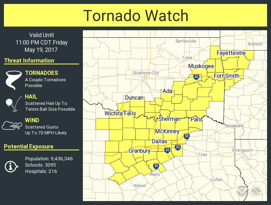
Tornado Watch Number 249
   NWS Storm Prediction Center Norman OK
   325 PM CDT Fri May 19 2017

   The NWS Storm Prediction Center has issued a

   * Tornado Watch for portions of
     northwest Arkansas
     southern and eastern Oklahoma
     northwest and north central Texas

   * Effective this Friday afternoon and evening from 325 PM until
     1100 PM CDT.

   * Primary threats include...
     A couple tornadoes possible
     Scattered damaging wind gusts to 70 mph likely
     Scattered large hail and isolated very large hail events to 2.5
       inches in diameter possible

   SUMMARY...Increasing thunderstorm development is expected along an
   outflow boundary across the region through the late afternoon and
   evening.  Initial storm development may include supercells, with a
   risk for severe hail and perhaps a couple of tornadoes, before
   activity consolidates into an upscale growing cluster of storms with
   increasing potential for damaging wind gusts this evening.


0 Comments