
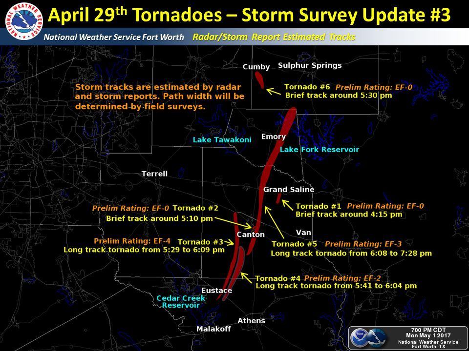
The National Weather Service offices in Fort Worth and Shreveport were out surveying damage tracks again today. The team from Fort Worth found two additional tornado tracks. In addition, we’ve now included two tornado tracks from near Lindale and Mineola. Finally, the Eustace tornado that went just west of Canton (the first of several tornadoes to impact the city) was upgraded to an EF-4 with maximum sustained winds estimated to be near 180 MPH. Eight tornadoes have been confirmed and additional damage surveys will be conducted on Tuesday. These survey results are subject to change. Please note that the Lindale and Mineola tornado tracks are not included in the graphic below.
National Weather Service Fort Worth TX
751 PM CDT Mon May 1 2017
…Public Information Statement…
…NWS Damage Survey For April 29 Tornado Event…
…Correction to peak wind speed for Log Cabin to Yantis Tornado…
…Updated information for Canton area tornado…
A National Weather Service survey team began to survey the damage
associated with at least four tornadoes that occurred in
Henderson, Van Zandt, Rains and Hopkins Counties. Two of the four
tornadoes were given a preliminary EF-0 rating while the other two
were long-tracked tornadoes with more significant damage, leading
to at least EF-3 ratings. Several survey teams will head out during
the day Monday to continue to assess the damage.
Other changes, which is still preliminary, is to update the Eustace
to West Canton damage to EF4, and to update the Log Cabin to Yantis
(East Canton) estimated winds.
This data is preliminary and some details may change over the next
few days as additional information is gathered. Additional,
and likely final information will be updated during the day on
Tuesday.
.Miller Grove/South Cumby Tornado…
Rating: EF0
Estimated Peak Wind: 85 mph
Path Length /statute/: 8.9 miles
Path Width /maximum/: 100 yards
Fatalities: 0
Injuries: 0
Start Date: 04/29/2017
Start Time: 05:32 PM CDT
Start Location: 3 SW Miller Grove / Hopkins County /
TX
Start Lat/Lon: 32.9898 / -95.8345
End Date: 04/29/2017
End Time: 05:50 PM CDT
End Location: 1.6 SSE Cumby / Hopkins County / TX
End Lat/Lon: 33.1149 / -95.8307
Summary: Residents recorded video of a tornado near FM 1567 and
County Road 1137 shortly after 530 PM. Tornado briefly had multiple
vortices but generally maintained a width of around 100 yards. The
tornado traveled north along County Road 1131 with mainly tree
damage observed. A metal barn was destroyed near CR 1131 and CR
1120.
A home was damaged along FM 275 south of I-30 near the end of the
track. The home burned after a large tree limb fell on the main
powerline into the home.
.Grand Saline Tornado…
Rating: EF0
Estimated Peak Wind: 80 mph
Path Length /statute/: 1.5 miles
Path Width /maximum/: 100 yards
Fatalities: 0
Injuries: 0
Start Date: 04/29/2017
Start Time: 04:15 PM CDT
Start Location: 5 SSW Grand Saline / Van Zandt County /
TX
Start Lat/Lon: 32.6056 / -95.7526
End Date: 04/29/2017
End Time: 04:17 PM CDT
End Location: 2 WSW Grand Saline / Van Zandt County /
TX
End Lat/Lon: 32.664 / -95.7413
Summary: Storm spotters and storm chasers observed a brief tornado
to the southwest of Grand Saline. Damage to trees was observed.
.East Canton #1 Tornado…
Rating: EF0
Estimated Peak Wind: 75 mph
Path Length /statute/: 2 miles
Path Width /maximum/: 75 yards
Fatalities: N/A
Injuries: N/A
Start Date: 04/29/2017
Start Time: 05:10 PM CDT
Start Location: 1 ESE Canton / Van Zandt County / TX
Start Lat/Lon: 32.5405 / -95.8429
End Date: 04/29/2017
End Time: 05:14 PM CDT
End Location: 3 NE Canton / Van Zandt County / TX
End Lat/Lon: 32.5784 / -95.8233
Summary: This brief tornado occurred in nearly the same area
of the larger tornado that came through later. This tornado caused
damage to trees and barns just southeast of the city center of
Canton.
.Eustace to West Canton Tornado…
Rating: EF4
Estimated Peak Wind: 180 mph
Path Length /statute/: 22 miles
Path Width /maximum/: 1760 yards
Fatalities: N/A
Injuries: N/A
Start Date: 04/29/2017
Start Time: 05:29 PM CDT
Start Location: 2 SSE Eustace / Henderson County / TX
Start Lat/Lon: 32.2572 / -96.0180
End Date: 04/29/2017
End Time: 06:09 PM CDT
End Location: 5 NNW Canton / Van Zandt County / TX
End Lat/Lon: 32.5528 / -95.9306
Summary: This tornado was the strongest of the tornado damage which
was surveyed today. Damage to four to five homes was noted where the
exterior walls collapsed in estimated 145 mph winds. Several cars and
numerous manufactured homes were damaged in the central part of this
tornado`s path. Additional details from this storm will be surveyed
on Monday.
.Eastern Canton Tornado (Log Cabin to NW of Yantis)…
Rating: EF3
Estimated Peak Wind: 145 mph
Path Length /statute/: 40 miles
Path Width /maximum/: 1760 yards
Fatalities: N/A
Injuries: N/A
Start Date: 04/29/2017
Start Time: 05:41 PM CDT
Start Location: 5 ENE Log Cabin / Henderson County / TX
Start Lat/Lon: 32.3991 / -95.8756
End Date: 04/29/2017
End Time: 07:28 PM CDT
End Location: 8 NW Yantis / Hopkins County / TX
End Lat/Lon: 32.9540 / -95.7021
Summary: This tornado will be better known as the mile wide tornado
which slammed into the east side of Canton. A survey crew found
damage consistent with winds around 130 to 140 mph within the damage
path. More damage will be surveyed again tomorrow.
It is not yet clear whether this 55 mile damage path (51 miles in a
straight line) is indeed one tornado, or was caused by more than
one. More details to come late Monday.
…Tornado near Lindale in Smith County…
Rating: EF-1
Estimated Peak Wind: 100-110 MPH
Path Length /Statute/: 3.0 Miles
Path Width /Maximum/: 570 Yards
Fatalities: 0
Injuries: 0
Start Date: Apr 29 2017
Start Time: 745 PM CDT
Start Location: 4 Miles Northwest of Lindale
Start Lat/Lon: 32.5671/ -95.4609
End Date: Apr 29 2017
End Time: 748 PM CDT
End Location: 5 Miles North of Lindale
End_Lat/Lon: 32.5915/ -95.4090
Survey Summary:This EF-1 tornado touched down west of highway 69 north
of Lindale TX. and move east northeast. Several trees were uprooted
and snapped along the path. The storms cross Highway 69 and dissipated
north of County Road 4118 after lifting a barn roof and dropping it back
onto the structure. The barn sustained extensive damage.
…Tornado near Mineola in Wood County…
Rating: EF-1
Estimated Peak Wind: 100-110 MPH
Path Length /Statute/: .5 Miles
Path Width /Maximum/: 190 yards
Fatalities: 0
Injuries: 0
Start Date: Apr 29 2017
Start Time: 748 PM CDT
Start Location: 2.5 Miles east of Mineola
Start Lat/Lon: 32.6481 / -95.4457
End Date: Apr 29 2017
End Time: 749 PM CDT
End Location: 3 Miles east of Mineola
End Lat/Lon: 32.6515 / -95.4385
Survey_Summary: This EF-1 tornado touched down east of highway 69
in Wood County Tx, just southeast of Mineola. The storm moved East
northeast and lifted as it crossed highway 80. Several trees were
uprooted and snapped along the path. One larger oak fell onto a
home just south of highway 80 causing extensive damage to the
home.
EF Scale: The Enhanced Fujita Scale classifies tornadoes into
the following categories.
EF0…Weak……65 TO 85 mph
EF1…Weak……86 TO 110 mph
EF2…Strong….111 TO 135 mph
EF3…Strong….136 TO 165 mph
EF4…Violent…166 TO 200mph
EF5…Violent…>200mph


0 Comments