
We’re going to be in an active severe weather pattern over the coming week. There will be several opportunities for severe weather. The threat for heavy rain and possible localized flooding will ramp up by the end of the work week and into the weekend. With over 268,500 square miles in Texas obviously we’re going to have to narrow the threat zones down. Tuesday and Thursday look to be the two most significant severe weather threat days, but severe storms are going to be possible today and perhaps on Friday.
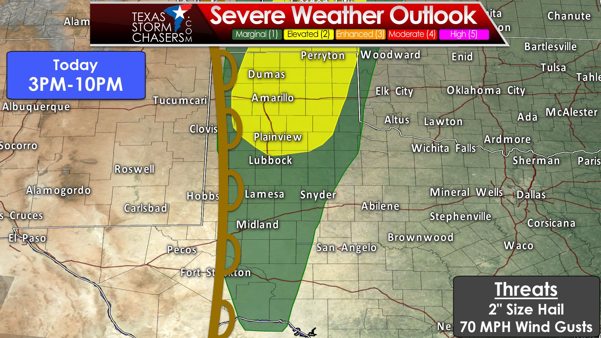
A “slight/standard” level 2 risk of severe weather includes most of the Texas Panhandle and portions of the South Plains this afternoon and evening. Stratford, Perryton, Canadian, Pampa, Dumas, Vega, Amarillo, Groom, Memphis, Tulia, Hereford, Dimmitt, Plainview, and Floydada are a few towns included. A “marginal” level 1 risk includes a majority of West Texas, the Permian Basin, into western sections of the Concho Valley. Childress, Spur, Lubbock, Brownfield, Post, Lamesa, Snyder, Andrews, Midland, Odessa, Crane, Big Lake, Iraan, and Sanderson are a few towns included. The level 2 zone is where the highest coverage of storms is expected later today, but isolated storms are possible in the level 1 zone. The time-window for today’s severe weather threat should start up around 3 PM CT and be concluding around 10 PM CT. The strongest storms today may produce large hail up to the size of tennis-balls and localized wind gusts over 70 MPH. Mediocre moisture levels and modest amounts of wind shear should keep today’s tornado threat very low.

The first storms should fire up around 3-4 PM this afternoon just east of a dryline in the Texas Panhandle. Stronger capping will keep thunderstorm chances lower with southward extent, so it’ll be a fist-fight on how far south storms are able to fire. I wouldn’t be surprised if one or two storms is able to fire up in the Permian Basin. Initial storms will be supercellular with a risk of large hail and localized damaging wind gusts. Storms that fire in the Panhandle may have a tendency to form into small lines or clusters within a couple hours of initiation. The threat of severe weather will continue through the early evening as storms slowly progress to the east. As storms move east off the Caprock by early evening they’ll run into a stronger cap. Storms will probably be dissipating by 10-11PM in the eastern Texas Panhandle, far Northwest Texas, and West Texas. Don’t be surprised if that ends up being closer to midnight, but the severe weather threat should be diminishing by 10 PM.

Fast-forward to Tuesday and we face the potential for a more substantial severe weather threat. A “slight/standard” level 2 risk of severe weather includes the eastern Texas Panhandle, northwest Texas, West-Central Texas, the Big Country, and the Concho Valley. Perryton, Canadian, Shamrock, Childress, Paducah, Vernon, Wichita Falls, Seymour, Paducah, Spur, Munday, Olney, Graham, Stamford, Snyder, Breckenridge, Big Spring, Abilene, Sterling City, Ballinger, Brownwood, San Angelo, Big Lake, Iraan, Ozona, Sonora, and Brady are a few towns included. A “marginal” level 1 risk surrounds the level 2 risk area. Tomorrow will likely set up to be a two-timed event. The first risk will develop by the mid-afternoon in the eastern Texas Panhandle extending into Northwest Texas. This initial risk will include the potential of supercells capable of producing destructive hail, damaging wind gusts, and a couple of tornadoes. The second time-frame is when the risk of strong to severe storms will spread south into the Big Country, the Concho Valley, and more of Northwest Texas late Tuesday evening into the predawn hours Wednesday. Large hail up to the size of 2 inches and wind gusts over 70 MPH will be possible with the stronger storms in the second round.
Tomorrow’s setup will be more favorable than today for severe weather in the eastern Texas Panhandle and perhaps Northwest Texas. One thing we’re going to have to watch for is how much low-level moisture is available. Surface dewpoints in the upper 60s would support lower cloud bases and a higher tornado threat. Dews in the lower 60s would tend to keep cloud bases higher with the tornado threat remaining lower. Storms today may produce outflow boundaries which could stick around and be focal points for thunderstorm initiation on Tuesday afternoon. Outflow boundaries can also locally enhance low level wind shear. I’m sure there will be a few surprises for tomorrow’s setup, but we won’t know those until we actually get into the morning hours Tuesday.
The first storms of the day will probably start to fire up by 3 to 5 PM just east of a dryline. Models are still debating where exactly the dryline will set up, but it looks like the highest threat for a storm will be in the eastern Texas Panhandle into West-Central Texas. The capping inversion will be stronger with southward extent, so the number of storms further south into the Big Country and Concho Valley is questionable during the afternoon hours. I do expect storms to really increase in coverage by the evening hours with our ‘second’ round, but we’ll talk more about that below. These afternoon storms may be supercellular with a risk of very large hail larger than the size of baseballs, localized damaging wind gusts, and perhaps a risk of tornadoes (subject to the caveats discussed above). High resolution models are also hinting at thunderstorm development also residual boundaries in far Northwest Texas and western Oklahoma late tomorrow afternoon. Storms will tend to move northeast with the most intense supercells moving more east/northeast. The most intense supercells may be long-track in that they continue for several hours. These are most likely in the eastern Texas Panhandle and western Oklahoma, with coverage/chances more isolated into West Texas. Even though coverage of storms will be lower with southward extent, any storms that do fire up will likely be just as severe. We may see the storms congeal into a cluster or squall line by mid-evening and move east into Oklahoma and Texoma.
The second round of storms, which may evolve from isolated storms during the afternoon, will likely begin to fire up by the early to mid-evening Tuesday in western sections of the Big Country and Concho Valley. Weather models suggest these initial storms will quickly grow upscale into a squall line. This squall line will move east through Northwest Texas, the Big Country, and the Concho Valley late Tuesday evening into the predawn hours Wednesday. The farther east they move the lower the risk of severe weather will be. I do believe some storms in the squall line will produce damaging wind gusts of 55 to 70 MPH and hail up to the size of golfballs. They may try and reach Interstate 35 around sunrise Wednesday in a weakened state before dissipating shortly thereafter.
At this point Wednesday looks like an in-between day with no severe weather risks outlined. I can’t rule out an isolated storm, but at this juncture it looks unlikely. Our next storm system will arrive on Thursday and bring the potential for active weather through the weekend. This includes the potential of severe thunderstorms, heavy rain, and localized flooding. We’ll need to get closer before we can get too detailed, but please check back for forecast updates through the week. Thursday has the potential to be quite active in the severe weather department in Northwest Texas, the Big Country, northward along the dryline all the way to Kansas.


0 Comments