
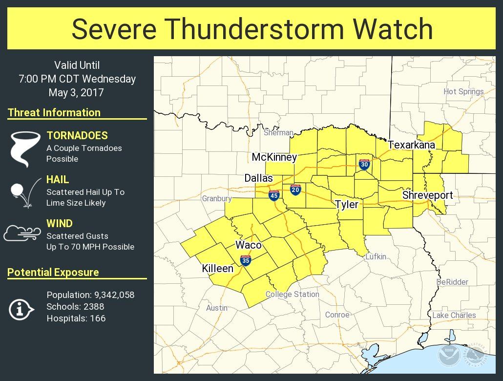
A severe thunderstorm watch is now in effect through 7 PM for portions of Northeast Texas, North Texas, and Central Texas. This watch includes the eastern half of the D/FW Metroplex, Tyler, Texarkana, Waco, and Killeen. The strongest storms my produce hail around the size of golfballs, localized damaging wind gusts to 70 MPH, and a low-end threat for a tornado or two. If we see any discrete storms form ahead of the developing squall line the potential for a few tornadoes would be enhanced.

A broken line of showers and thunderstorms has developed just ahead of a cold front in North Texas. These showers/storms extend from Hico to Cedar Hill to McKinney to Bonham. The one actual storm at this point is just east of Mansfield moving toward Cedar Hill. That storm has a history of producing small hail and we’re watching it for intensification trends. We’ll probably see additional strong storms fire up in the coming hours as well. The strongest of which may produce hail up to the size of golfballs and localized wind gusts over 60 MPH.
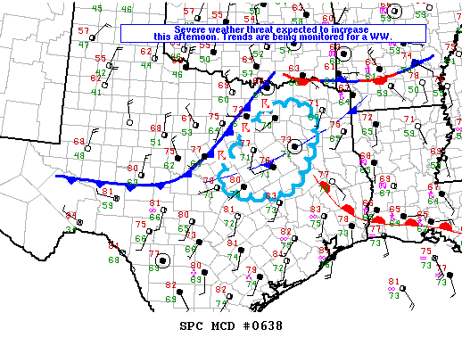
There remains uncertainty on how far west the line of storms will form this afternoon in Central Texas. Current indications are that the best chance for severe storms will be along and east of Interstate 35. However, if storms are able to develop further west along the cold front, they would have an attendant risk of being strong with hail and damaging winds. The primary lifting mechanism for thunderstorm development will be the cold front. As it moves south, the line of storms will as well through the evening hours.

The High Resolution Rapid Refresh (HRRR) model does have the best chance of storms east of Interstate 35 this afternoon. If the cap is a bit weaker or another unknown lifting mechanism exists we may see development occur back west to Interstate 35. Regardless the line of storms should be moving off the Southeast Texas coast by 8-9 PM. The strongest parts of the line may produce hail up to the size of ping-pong balls and localized damaging wind gusts. The threat for tornadoes is low, but not zero. If we have any discrete storms form ahead (or south) of the squall line, we’d have to watch for a localized, but enhanced threat of tornadoes. Storms earlier this morning may have produced outflow boundaries. Those boundaries will be watched for signs of low-level wind shear enhancement. Likewise, those boundaries could help an isolated storm or two form. Any isolated storm near an outflow boundary would be capable of producing all modes of severe weather – with the highest (relative) threat in East and Southeast Texas this afternoon.


0 Comments