

We have an “enhanced” level 3 risk of severe weather for this afternoon and evening in portions of Northwest Texas. This includes Shamrock, Wellington, Childress, Quanah, Vernon, to just west of Burkburnett. Southwest Oklahoma is also included in this level 3 risk with Hollis, Mangum, Altus, Snyder, Lawton, Apache, Hobart, Cordell, to Elk City and Sayre. This level 3 risk is where the risk for tornadoes and very large hail will be highest late this afternoon and evening with any discrete supercells. A “slight/elevated” level 2 risk includes the northeastern half of the Texas Panhandle, the remainder of Northwest Texas, and south into the Big Country and Concho Valley. The risk for the Big Country and Concho Valley will be tonight. The strongest storms this afternoon across the Panhandle may produce large hail, damaging winds, and potentially a couple of tornadoes. The risk tonight in the Big Country and Concho Valley will be in the form of hail up to the size of golfballs and damaging wind gusts over 70 MPH. An isolated tornado cannot be ruled out with tonight’s activity, but the risk will be considerably lower than the afternoon threat further north. A “marginal” level 1 risk runs west of a Sherman to Hamilton to Eagle Pass line – and marks where an isolated severe weather threat may occur late tonight.
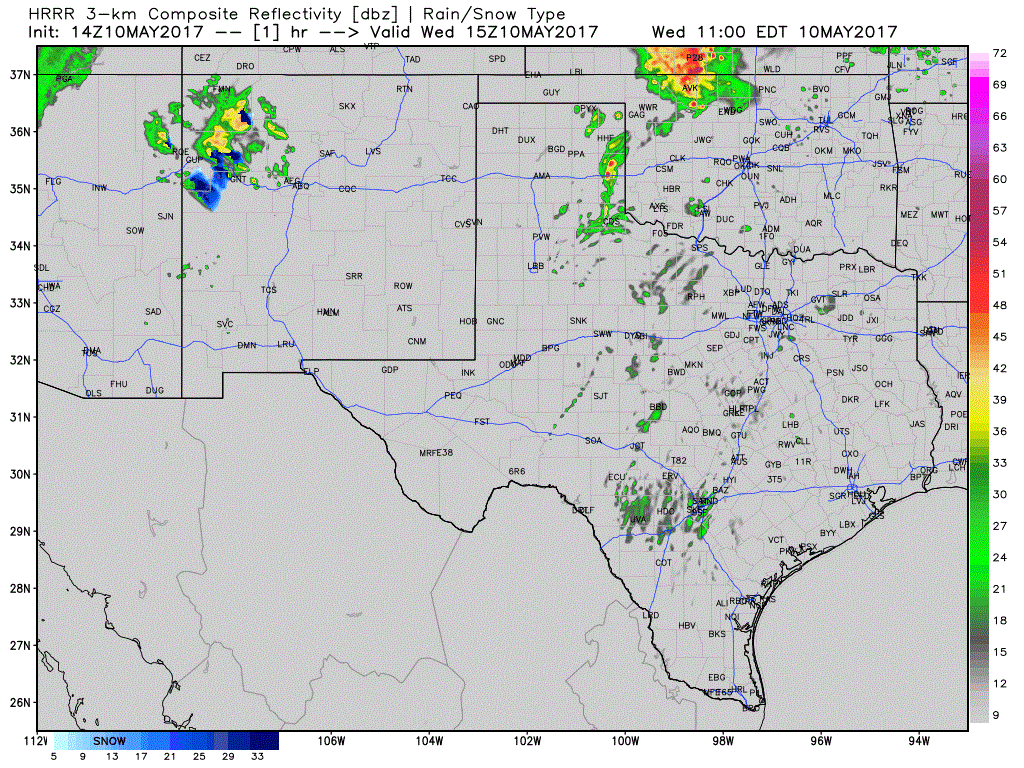
This animation is from the 9 AM run of the High Resolution Rapid Refresh (HRRR) and shows what may play out today and tonight. This loop runs through 2 AM CT Thursday. Keep in mind the locations/timing may be off, so don’t expect today to play out exactly as depicted. Our initial thunderstorms may fire up relatively early, by 3 PM, across eastern sections of West Texas into the eastern/northeastern Texas Panhandle. You can thank a weak cap and numerous outflow boundaries for the early initiation time. Storms should move north/northeast. The strongest will be severe with a risk of very large hail, localized damaging wind gusts, and may be tornadic. The highest tornado threat may be just north of the Red River in Southwest Oklahoma early this evening, but it will be way too close to call. We’ll also need to watch the storms in the northern/northeastern Texas Panhandle for a tornado risk. The risk for tornadoes will be highest with any discrete, intense supercell. Most of these storms should east/northeast into Oklahoma or weaken by about 9 PM. Focus then shifts further south where a line or cluster of thunderstorms is expected to develop late this evening in the Big Country and Concho Valley. Development may not be until after 10 PM. Once storms fire up they’ll likely go linear (or into a line) fairly quickly. The strongest storms in the squall line may produce hail up to the size of golfballs and localized damaging wind gusts up to 70 MPH. Localized flooding and a tornado cannot be ruled out. The linear thunderstorm mode and the time of night should keep the tornado threat low. This line of storms will slowly move east, but will run into a stronger cap before it arrives in the Hill Country and Central Texas early Thursday morning. That cap should squash the storms fairly quickly, but a good chance of rain does exsist tonight in the Concho Valley.
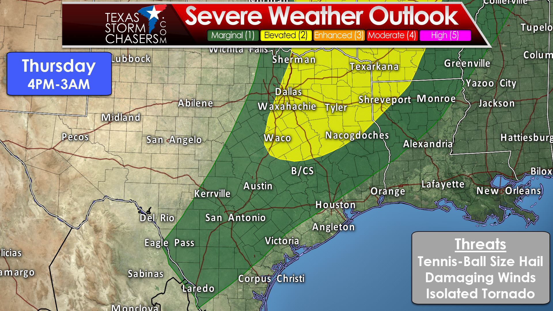
The events of today will play a big role in how Thursday’s severe weather setup plays out. A dryline, cold front, and area of low pressure will move east. The Storm Prediction Center has a “slight/elevated” level 2 risk of severe weather across Northeast Texas, eastern North Texas, and eastern Central Texas. Sherman, Dallas, Waco, Buffalo, Palestine, Tyler, Canton, Sulphur Springs, Paris, Texarkana, Atlanta, Longview, Carthage, and Nacogdoches are a few towns included in this risk. A “marginal” level 1 risk includes more of North Texas, Central Texas, the Hill Country, Central Texas, the Brazos Valley, East Texas, and parts of Southeast Texas. Gainesville, Decatur, Fort Worth, Cleburne, Hamilton, Lampasas, Killeen, Fredericksburg, Austin, Boerne, San Antonio, Uvalde, Eagle Pass, Pleasanton, Cotulla, Laredo, Freer, Beeville, Cuero, La Grange, Sealy, Conroe, Huntsville, College Station, Livingston, Woodville, Jasper, and San Augustine are a few towns included in this risk. The highest coverage of thunderstorms is expected to be in the level 2 risk zone.

The events of today/tonight will play a role in how tomorrow plays out. If we have more widespread clouds the risk of severe weather may be lower. Likewise, more sun indicates a higher threat for severe weather. Low-level wind shear will be weaker on Thursday than today, so the threat for tornadoes should be low. An exception may be if any discrete storm interacts with an outflow boundary left over from tonight’s activity further west. The primary threat will be large hail up to the size of tennis-balls and localized damaging wind gusts over 60 MPH. If the dryline ends up further west than anticipated the risk for severe weather could include more of D/FW. Right now it looks like storms will fire up on or east of I-35 in D/FW by late Thursday afternoon. These storms may grow upscale into a squall line that impacts portions of Northeast Texas, East Texas, and Central Texas tomorrow evening. Confidence in this aspect of the forecast is lower than average due to uncertainties regarding how today’s evolution will impact Thursday. Please check back for forecast updates tomorrow morning.


0 Comments