
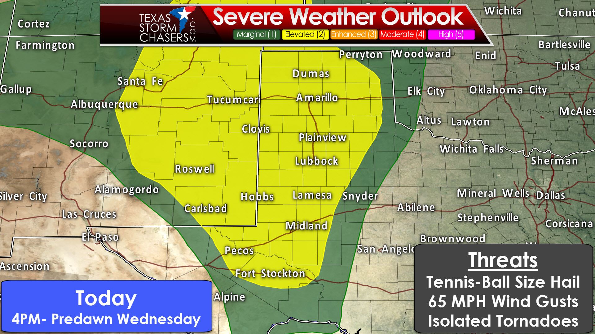
A “slight/elevated” level 2 risk of severe weather cnompasses most of the Texas Panhandle, West Texas, and the Permian Basin this afternoon into late tonight. A “marginal” level 1 risk of severe weather surrounds the level 2 risk within a zone of about 25-50 miles. This indicates where there are storms later today and tonight we’re expecting the possibility of severe weather. There isn’t much of a buffer zone since where storms are possible, they may be severe. Where storms aren’t expected severe weather likewise won’t occur. Isolated to widely scattered thunderstorms may develop as soon as 4-5PM CT in eastern New Mexico, the Permian Basin, and far West Texas. Ingredients within that zone will be favorable for supercells capable of producing very large hail, localized damaging wind gusts, and the possibility of tornadoes. Residual outflow boundaries from yesterday’s storms in eastern New Mexico may become focus points for thunderstorm development and enhanced low level wind shear. Storms that develop in eastern New Mexico will approach or move into West Texas by the early evening hours. There is also the possibility of storm development in West Texas by the late afternoon. Storms will move northeast and with a decent possibility of being severe.
The high resolution rapid refresh (HRRR) model shows this evening’s scenario quite well. We’re expecting two rounds of convection. The first will be the potential for isolated supercells in the late afternoon and early evening. The second round will be late tonight as a squall line moves from west to east across West Texas and the Texas Panhandle. The first round will bring localized, but potentially high impacts. The squall line will bring widespread rain with the potential for localized damaging wind gusts and hail. The discrete afternoon/evening storms will probably be supercellular with a risk of very large hail, localized damaging wind gusts, and a tornado risk. Some of the hail may be larger than the size of tennis-balls. The potential for a tornado will be highest with any storm near an outflow boundary. The squall line late tonight will be capable of producing a quick one to two inches of rain, wind gusts of 40 to 70 MPH, and hail up to the size of ping-pong balls. Not everyone will see severe weather with the squall line tonight, but there is a good chance of rain. Current projections have the squall line exiting the eastern Texas Panhandle around 7 AM on Wednesday. The threat for severe weather should slowly decrease early Wednesday through the pre-dawn hours.

A “slight/elevated” level 2 risk of severe weather includes the eastern Texas Panhandle and Northwest Texas for Wednesday afternoon and evening. A “marginal” level 1 risk includes western North Texas, the Big Country, Concho Valley, down to Del Rio. Tomorrow’s setup and thunderstorm evolution will depend on what all transpires tonight. Outflow boundaries left over from the storms today/tonight will dictate where the highest risk zones set up for tomorrow. If rain/clouds hold around longer in the Panhandle the threat for afternoon severe weather may be lower. Likewise, if we see several hours of heating, we could see the threat for storm redevelopment increase. A couple rounds of storms are possible on Wednesday.
- Previously described scenario with the early morning squall line in the eastern Texas Panhandle and perhaps Northwest Texas. That should be weakening through sunrise and move into Oklahoma shortly thereafter. We’ll have to keep tabs on how far south that line develops as it could infringe on the Red River counties of Texoma Wednesday morning.
- An outflow boundary from the squall line may move into western North Texas by the mid-morning hours Wednesday. It is not out of the question to see isolated thunderstorm development occur along that boundary. Should storms pop-up they could produce large hail in western North Texas, along and west of Interstate 35/35W. They would be elevated above the cap, so the tornado and damaging wind threat would be very low.
- Isolated supercellular development is possible by the early/mid-afternoon hours in the eastern Texas Panhandle. Residual outflow boundaries and a weak cap could allow storm development to occur by 3 PM. These storms would be in an environment supportive of supercells capable of very large hail, localized damaging wind gusts, and a couple of tornadoes. This early afternoon threat is conditional on the squall line clearing out early enough to let the atmosphere destabilize. Storms would move north/northeast.
- By the mid to late afternoon isolated to scattered thunderstorm development is expected in the eastern and northeastern Texas Panhandle extending north into the Oklahoma Panhandle and Southwest Texas. These storms would move northeast and possibly be severe with a risk of very large hail, localized damaging wind gusts, and perhaps a couple of tornadoes. This is also conditional on the atmosphere destabilizing behind the morning squall line. However, unlike the conditional early afternoon threat, storms are still more likely. Their intensity will be determined by the atmosphere’s recovery. I do think we are going to see some severe weather with this scenario.
- Thunderstorms are possible by the late evening hours across the Concho Valley and Southwest Texas. These storms would move northeast and possibly be severe with large hail and damaging winds.
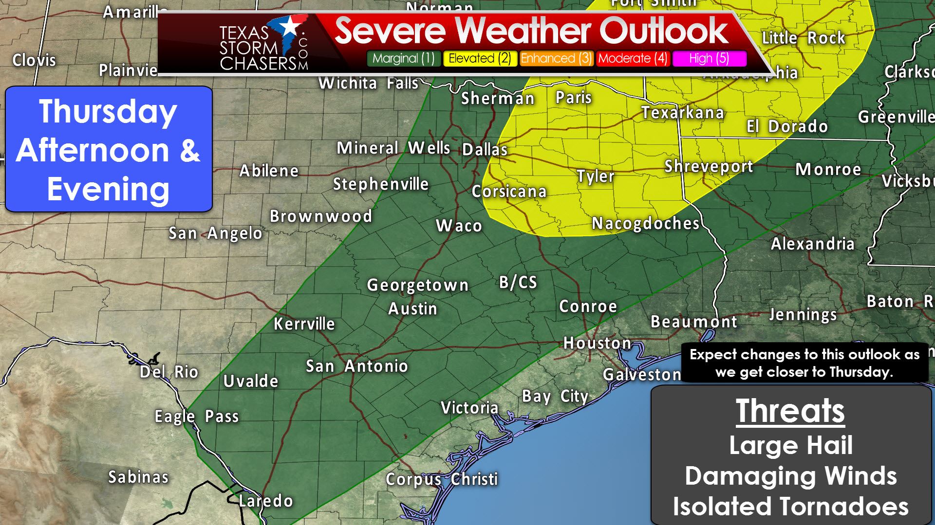
Meanwhile, all of those factors will play a role in where the threat of severe weather develops on Thursday. A dryline will move east to near Highway 281. Conditions east of the dryline are expected to be supportive of organized thunderstorms. Questions remain on how many storms will develop and just what ingredients will be in place. Wednesday’s storms will play a role Thursday’s setup with residual outflow boundaries. We’ll also have to see how far east the dryline can make it by late afternoon. Expect the severe weather outlook to change as confidence in one specific solution increases. The primary severe weather threat does look to be large hail at the moment. Damaging wind gusts and a low-end tornado threat are secondary concerns. Any outflow boundaries or increase in low level wind shear could result in an increased tornado threat, but those are factors we won’t be able to determine until Wednesday night or Thursday morning.


0 Comments