
The National Weather Service have completed a majority of their storm surveys for the April 29, 2017 tornado outbreak. A total of nine tornadoes have been confirmed across eastern North Texas and East Texas. The first tornado touched down shortly after 4 PM and the last lifted just before 8 PM. The most violent tornado has been rated an EF-4 with estimated maximum sustained winds near 180 MPH. The Eustace/West Canton and East Canton/Emory tornadoes were each one mile wide at their maximum width. In addition, the East Canton to Emory tornado was down for 80 minutes. That makes it one of the most long-lived tornadoes in recorded history for North Texas, perhaps back to the late 1950s. Specific records for the start/end time of tornadoes were not strictly kept until the 1990s. This day goes to show that all severe weather days should be monitored, even those that aren’t expected to be a tornado outbreak. This day went from an anticipated squall line with hail and damaging winds to a supercellular mode with enhanced low level wind shear.
…NWS DAMAGE SURVEY FOR 04/29/17 TORNADOES…
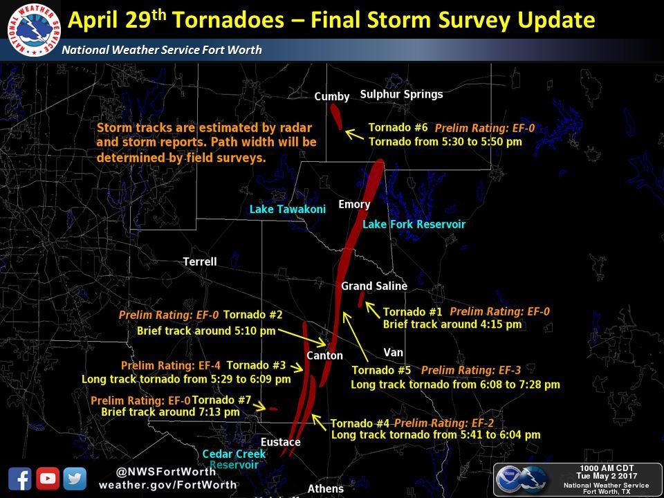
.Overview…
National Weather Service damage survey teams continued to survey
the damage across Henderson, Van Zandt, Rains and Hopkins
Counties. Multiple teams were deployed Sunday and Monday to piece
together the events that unfolded on April 29th, 2017. A total of
7 tornadoes occurred between 4:15 pm and 7:13 pm over the four
counties.
Synoptically, a deep low pressure system near the Four corners
continued to move east, causing early morning thunderstorms to
develop along the Texas Panhandle and into Oklahoma. A cold front
was moving southeast across the state and entered our northwestern
counties around sunrise. The strength of the cap was sufficient to
hamper any development until mid afternoon. Deep forcing for
ascent approached from from the west while remnant boundaries
associated with convection over far East Texas and West Louisiana
moved in from the east. By 3:30 PM, several parameters came
together for the rapid development of severe storms east of
Interstate 35/35E. Pre-frontal convection led to the development
of supercells, producing numerous tornadoes over a relatively
small area. Additional storm development quickly developed along
the cold front with several reports of large hail, and eventually
producing a brief EF-0 Quasi-Linear Convective System (QLCS)
tornado (Tornado #7).
The survey crew teams determined yesterday that there was indeed
a nearly 55 mile damage swath, yet found evidence that there
were two tornadoes which caused the damage. One tornado began in
western Henderson County and moved into central Van Zandt County.
This tornado occluded and dissipated, and a second, long track
tornado began nearby. This second tornado was the EF-3 which
produced damage on the east side of Canton, Fruitvale, Emory,
and finally dissipating near Lake Fork. The first tornado had
a track of approximately 12 miles, while the other had a track of
nearly 42 miles.
The tornadoes are listed below in chronological order and may
not match the same order as previous public information statements.
The tornado fatalities are listed below, yet more investigation is
needed to determine the number of injuries by each tornado. It is
known that at least 49 people were transported to area hospitals
because of Saturday`s tornadoes. These tornado numbers should
match the tornado numbering system on graphics on the main
NWS Fort Worth website.
.Tornado #1 Grand Saline Area…
Rating: EF0
Estimated Peak Wind: 80 mph
Path Length /statute/: 1.54 miles
Path Width /maximum/: 100 yards
Fatalities: 0
Injuries: 0
Start Date: 04/29/2017
Start Time: 04:15 PM CDT
Start Location: 5 SSW Grand Saline / Van Zandt County /
TX
Start Lat/Lon: 32.6056 / -95.7526
End Date: 04/29/2017
End Time: 04:18 PM CDT
End Location: 4 SSW Grand Saline / Van Zandt County /
TX
End Lat/Lon: 32.6272 / -95.7457
Summary: This tornado was observed by storm spotters and storm
chasers. This was fairly brief tornado, with damage noted only to
trees.
.Tornado #2 East Canton…
Rating: EF0
Estimated Peak Wind: 75 mph
Path Length /statute/: 1.81 miles
Path Width /maximum/: 75 yards
Fatalities: 0
Injuries: 0
Start Date: 04/29/2017
Start Time: 05:10 PM CDT
Start Location: 1 ESE Canton / Van Zandt County / TX
Start Lat/Lon: 32.5405 / -95.8429
End Date: 04/29/2017
End Time: 05:14 PM CDT
End Location: 2 ENE Canton / Van Zandt County / TX
End Lat/Lon: 32.5642 / -95.8299
Summary: This brief tornado occurred in nearly the same area of the
larger tornado which came through about an hour later. This tornado
caused damage to trees and a few barns, just southeast of the
city center of Canton.
.Tornado #3 Eustace to West Canton…
Rating: EF4
Estimated Peak Wind: 180 mph
Path Length /statute/: 21.94 miles
Path Width /maximum/: 1760 yards
Fatalities: 2
Injuries: Unknown
Start Date: 04/29/2017
Start Time: 05:29 PM CDT
Start Location: 2 N Log Cabin / Henderson County / TX
Start Lat/Lon: 32.2572 / -96.018
End Date: 04/29/2017
End Time: 06:09 PM CDT
End Location: 4 W Canton / Van Zandt County / TX
End Lat/Lon: 32.5528 / -95.9306
Summary: This was the strongest tornado to occur during this event,
with damage consistent with an EF4 winds was surveyed in the
community of Old Bethel in Van Zandt County.
A survey team found that this tornado began near the intersection of
FM 2813 and 2329, or about two miles north of the town of Log Cabin
in northwestern Henderson County. The tornado then tracked northeast
and crossed US-175 2 miles southeast of Eustace, before moving
towards the north after crossing FM 2709. Mainly tree damage was
observed from this location to the Van Zandt/Henderson County
border. More substantial damage to several residences then occurred
as this tornado crossed into southern Van Zandt County, consistent
with winds around 100 to 120 mph. Complete destruction to a mobile
home was observed here.
The tornado continued northward, and produced the most substantial
damage in a narrow corridor near the intersection of FM 2301 and
2313. All walls of a well constructed two story brick house
collapsed, with additional severe debarking of numerous trees
occurring on the property.
This damage is consistent with wind speeds around 175 to 185 mph. The
tornado reached its greatest width, roughly 1 mile, as it crossed SH-
198 where numerous high tension towers were demolished. The tornado
then gradually weakened as it curled towards the northwest, before
finally dissipating near SH-243, 2 miles outside of Canton.
.Tornado #4 Henderson County to South Van Zandt County…
Rating: EF2
Estimated Peak Wind: 125 mph
Path Length /statute/: 11.82 miles
Path Width /maximum/: 100 yards
Fatalities: 0
Injuries: Unknown
Start Date: 04/29/2017
Start Time: 05:41 PM CDT
Start Location: 3 NE Log Cabin / Henderson County / TX
Start Lat/Lon: 32.251 / -95.9803
End Date: 04/29/2017
End Time: 06:04 PM CDT
End Location: 9 NE Eustace / Van Zandt County / TX
End Lat/Lon: 32.4061 / -95.9025
Summary: This tornado developed northeast of Log Cabin with the first
visible damage associated to snapped trees. As the tornado moved
north/northeast, a tall communications tower was snapped in half.
Eventually, the tornado crossed paths with several homes which led
to complete destruction and many debarked trees. The damage path
continued to the northeast, eventually stopping near the
intersection of Van Zandt County Road 2903 and FM 1256. As this
tornado occluded and dissipated, the next tornado began in the next
few minutes.
.Tornado #5 Eastern Canton Tornado…
Rating: EF3
Estimated Peak Wind: 145 mph
Path Length /statute/: 40.05 miles
Path Width /maximum/: 1760 yards
Fatalities: 2
Injuries: Unknown
Start Date: 04/29/2017
Start Time: 06:08 PM CDT
Start Location: 10 S Canton / Van Zandt County / TX
Start Lat/Lon: 32.3991 / -95.8756
End Date: 04/29/2017
End Time: 07:28 PM CDT
End Location: 6 NE Emory / Rains County / TX
End Lat/Lon: 32.954 / -95.6987
Summary: This tornado began as tornado #4 dissipated and the
supercell cycled another tornado about a mile to the east and
northeast. This tornado quickly grew to a large tornado, becoming
slightly less than one mile wide at its widest point. The tornado
was at the strongest near Interstate 20 and FM 17 just north of
Canton. The survey crews found continuous damage between Canton
and Fruitvale, and then additional damage as far north as Emory,
and Lake Fork. Several homes, businesses, and farm buildings
were damaged or destroyed in the 40 mile continuous damage path.
This tornado occurred for over an hour, and spanned most of Van
Zandt, and nearly all of Rains Counties during the 80 minute track.
.Tornado #6 Miller Grove to Cumby Area…
Rating: EF0
Estimated Peak Wind: 85 mph
Path Length /statute/: 8.93 miles
Path Width /maximum/: 100 yards
Fatalities: 0
Injuries: Unknown
Start Date: 04/29/2017
Start Time: 06:32 PM CDT
Start Location: 4 NNE Point / Hopkins County / TX
Start Lat/Lon: 32.9906 / -95.836
End Date: 04/29/2017
End Time: 06:50 PM CDT
End Location: 1 SSE Cumby / Hopkins County / TX
End Lat/Lon: 33.1146 / -95.8302
Summary: Residents recorded video of a tornado near FM 1567 and
County Road 1137 shortly after 530 PM. Tornado briefly had multiple
vortices but generally maintained a width of around 100 yards. The
tornado traveled north along County Road 1131 with mainly tree
damage observed. A metal barn was destroyed near CR 1131 and CR
1120. A home was damaged along FM 275 south of I-30 near the end
of the track. The home burned after a large tree limb fell on the
main powerline into the home.
.Tornado # 7 Southwest Van Zandt County…
Rating: EF0
Estimated Peak Wind: 80 mph
Path Length /statute/: 0.88 miles
Path Width /maximum/: 80 yards
Fatalities: 0
Injuries: 0
Start Date: 04/29/2017
Start Time: 07:13 PM CDT
Start Location: 3 ENE Mabank / Van Zandt County / TX
Start Lat/Lon: 32.3859 / -96.0528
End Date: 04/29/2017
End Time: 07:15 PM CDT
End Location: 4 ENE Mabank / Van Zandt County / TX
End Lat/Lon: 32.3822 / -96.0384
Summary: This tornado was observed by residents of southwest Van
Zandt County, south of Van Zandt County road 2308. This tornado
occurred over open fields.
.Tornado # 8 near Lindale in Smith County...
Rating: EF-1
Estimated Peak Wind: 100-110 MPH
Path Length /Statute/: 3.0 Miles
Path Width /Maximum/: 570 Yards
Fatalities: 0
Injuries: 0
Start Date: Apr 29 2017
Start Time: 745 PM CDT
Start Location: 4 Miles Northwest of Lindale
Start Lat/Lon: 32.5671/ -95.4609
End Date: Apr 29 2017
End Time: 748 PM CDT
End Location: 5 Miles North of Lindale
End_Lat/Lon: 32.5915/ -95.4090
Survey Summary:This EF-1 tornado touched down west of highway 69 north
of Lindale TX. and move east northeast. Several trees were uprooted
and snapped along the path. The storms cross Highway 69 and dissipated
north of County Road 4118 after lifting a barn roof and dropping it back
onto the structure. The barn sustained extensive damage.
.Tornado #9 near Mineola in Wood County…
Rating: EF-1
Estimated Peak Wind: 100-110 MPH
Path Length /Statute/: .5 Miles
Path Width /Maximum/: 190 yards
Fatalities: 0
Injuries: 0
Start Date: Apr 29 2017
Start Time: 748 PM CDT
Start Location: 2.5 Miles east of Mineola
Start Lat/Lon: 32.6481 / -95.4457
End Date: Apr 29 2017
End Time: 749 PM CDT
End Location: 3 Miles east of Mineola
End Lat/Lon: 32.6515 / -95.4385
Survey_Summary: This EF-1 tornado touched down east of highway 69
in Wood County Tx, just southeast of Mineola. The storm moved East
northeast and lifted as it crossed highway 80. Several trees were
uprooted and snapped along the path. One larger oak fell onto a
home just south of highway 80 causing extensive damage to the
home.
EF Scale: The Enhanced Fujita Scale classifies tornadoes into the
following categories.
EF0…Weak……65 TO 85 mph
EF1…Weak……86 TO 110 mph
EF2…Strong….111 TO 135 mph
EF3…Strong….136 TO165 mph
EF4…Violent…166 TO 200mph
EF5…Violent…>200mph


0 Comments