
A Tornado WATCH continues for portions of northeast and east central Texas until 10pm this evening.
Counties included in the WATCH are as follows: Anderson, Freestone, Henderson, Leon, Limestone, Delta, Fannin, Hopkins, Hunt, Kaufman, Lamar, Navarro, Rains, Rockwall and Van Zandt.
This includes the cities of Athens, Bonham, Buffalo, Canton, Centerville, Commerce, Cooper, Corsicana, East Tawakoni, Edgewood, Emory, Fairfield, Forney, Grand Saline, Greenville, Groesbeck, Gun Barrel City, Heath, Jewett, Kaufman, Mexia, Normangee, Oakwood, Palestine, Paris, Point, Rockwall, Sulphur Springs, Teague, Terrell, Van, Wills Point and Wortham.
Additional development of severe storms capable of producing tornadoes is expected for the next couple of hours across northeast Texas and the eastern portions of central Texas along and east of the I-45 corridor. We’ve already had one significant tornado impact the Canton, TX area this afternoon. This storm has now moved north of the Canton passing just east of Emory as I’m typing this. While an outbreak of numerous tornadoes is NOT expected, we could see a few more develop before these storms begin to lose their tornadic potential later this evening. Residents within and near the tornado WATCH area will need to keep an eye out for severe weather in their area over the next several hours. Monitor local media and have a way to receive weather warnings if you’re out and about. If a warning is issued for your area, do not wait for visual confirmation of the tornado to seek shelter as it will likely be rain-wrapped and you won’t see it until it’s right on top of you.
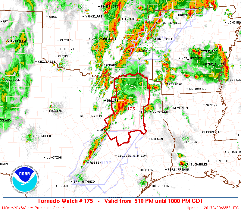
Tornado Watch Number 175
   NWS Storm Prediction Center Norman OK
   510 PM CDT Sat Apr 29 2017

   The NWS Storm Prediction Center has issued a

   * Tornado Watch for portions of
     Northeast Texas

   * Effective this Saturday afternoon and evening from 510 PM until
     1000 PM CDT.

   * Primary threats include...
     A couple tornadoes possible
     Isolated very large hail events to 2 inches in diameter possible
     Isolated damaging wind gusts to 70 mph possible

   SUMMARY...A band of storms ahead of a cold front and on the west
   edge of an outflow boundary will be in a zone supportive of
   supercells with the potential to produce a couple of tornadoes,
   along with isolated large hail and damaging winds.

   The tornado watch area is approximately along and 40 statute miles
   east and west of a line from 15 miles northwest of Paris TX to 40
   miles southeast of Corsicana TX.


0 Comments