
Thunderstorms are starting to intensify across the Serranias del Burro mountains in northern Mexico (west/southwest of Del Rio). These storms are expected to move into the Edwards Plateau and southern Hill Country later tonight. Some of these storms will be severe with a risk of very large hail and localized damaging wind gusts. As time goes on and they get further east, the threat for a few tornadoes will increase. This will be a nocturnal threat – and continue well into the morning hours Sunday. This will be the ‘beginning’ of what should be a significant severe weather threat into Sunday.
 Mesoscale Discussion 0396
NWS Storm Prediction Center Norman OK
1006 PM CDT Sat Apr 01 2017
Areas affected...Portions of the Edwards Plateau and the Texas Hill
Country
Concerning...Severe potential...Watch likely
Valid 020306Z - 020500Z
Probability of Watch Issuance...80 percent
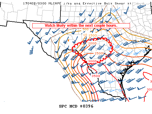
SUMMARY...Thunderstorms will increase in coverage across southwest
Texas late this evening, before eventually spreading east/northeast
towards morning. Initially, large hail and damaging winds will be
the primary threat. However, a threat for a couple tornadoes will
likely materialize overnight as storms develop east. Watch issuance
is likely within the next couple of hours.
DISCUSSION...Convection has once again blossomed over the Serranias
del Burro mountains late this evening, likely in response to
amplifying large-scale ascent related to a strengthening upper level
jet. It is uncertain whether these cells are the beginning of a more
organized expansion of convection through the overnight hours.
However, as a southeasterly low-level jet and related moist/warm
advection intensify over the next several hours, confidence is high
that more widespread thunderstorm activity will develop near the Rio
Grande ahead of a cold front to the northwest. Initially, this
activity will interact with surface dew points in the upper 50s to
near 60. Combined with steep mid-level lapse rates and ample
effective shear (both observed in the 00Z DRT sounding), these cells
will be capable of large hail and damaging winds.
Through the early overnight however, low-level moisture will surge
westward as surface-to-850mb east/southeasterly flow intensifies.
Surface observations depict dew points in the mid/upper 60s over
south-central Texas, and this greater moisture should advance
westward quickly. Therefore, cells will evolve eastward into an
environment characterized by 2000+ J/kg of MLCAPE. Combined with
notable low-level speed shear and some veering with height, a threat
for a couple tornadoes should gradually increase through the night,
especially with eastward extent. Therefore, despite the uncertainty
regarding timing of the organized severe threat, a watch will be
likely within the next couple hours.
 Mesoscale Discussion 0396
   NWS Storm Prediction Center Norman OK
   1006 PM CDT Sat Apr 01 2017

   Areas affected...Portions of the Edwards Plateau and the Texas Hill
   Country

   Concerning...Severe potential...Watch likely

   Valid 020306Z - 020500Z

   Probability of Watch Issuance...80 percent

   SUMMARY...Thunderstorms will increase in coverage across southwest
   Texas late this evening, before eventually spreading east/northeast
   towards morning. Initially, large hail and damaging winds will be
   the primary threat. However, a threat for a couple tornadoes will
   likely materialize overnight as storms develop east. Watch issuance
   is likely within the next couple of hours.

   DISCUSSION...Convection has once again blossomed over the Serranias
   del Burro mountains late this evening, likely in response to
   amplifying large-scale ascent related to a strengthening upper level
   jet. It is uncertain whether these cells are the beginning of a more
   organized expansion of convection through the overnight hours.
   However, as a southeasterly low-level jet and related moist/warm
   advection intensify over the next several hours, confidence is high
   that more widespread thunderstorm activity will develop near the Rio
   Grande ahead of a cold front to the northwest. Initially, this
   activity will interact with surface dew points in the upper 50s to
   near 60. Combined with steep mid-level lapse rates and ample
   effective shear (both observed in the 00Z DRT sounding), these cells
   will be capable of large hail and damaging winds.

   Through the early overnight however, low-level moisture will surge
   westward as surface-to-850mb east/southeasterly flow intensifies.
   Surface observations depict dew points in the mid/upper 60s over
   south-central Texas, and this greater moisture should advance
   westward quickly. Therefore, cells will evolve eastward into an
   environment characterized by 2000+ J/kg of MLCAPE. Combined with
   notable low-level speed shear and some veering with height, a threat
   for a couple tornadoes should gradually increase through the night,
   especially with eastward extent. Therefore, despite the uncertainty
   regarding timing of the organized severe threat, a watch will be
   likely within the next couple hours.


0 Comments