
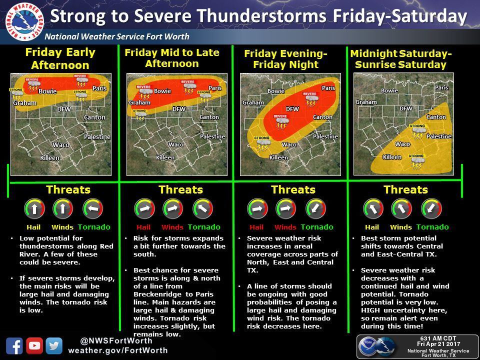
We’re expecting a fairly busy weather day across Texoma, Northeast Texas, and portions of North Texas. At this time we have a level 3 risk of severe weather north of a line from Bowie to Denton to Greenville to Clarksville line. A level 2 risk runs along/north from near Vernon to Holliday to Metcalf Gap to Cresson to Waxahachie to Kemp to Big Sandy to Jefferson to Vivian. A level 1 risk runs about another 25 miles west/south of the level 2 risk. These risks are delineated based off the probability of experiencing severe weather within 25 miles of your location.

- A Level 1 (Marginal) risk is about a 5% chance of severe weather within 25 miles of your location
- A Level 2 (Slight/Elevated) risk is about a 15% chance of severe weather within 25 miles of your location
- A Level 3 (Enhanced) risk is about a 30% chance of severe weather within 25 miles of your location
Depending on how trends look over the coming hours we may see these risks expanded a bit further south in later updates. Severe weather – in this case – is defined as hail the size of quarters or wind gusts over 58 MPH. Obviously tornadoes would be considered severe, but we use a different probability scale in relation to the risk zones. I won’t complicate this any further by mentioning those, but isolated tornadoes will be possible today, especially in the level 3 risk zone. You can see a closer-up view of your severe weather risk today by visiting Your Local Weather and our Severe Weather Center.
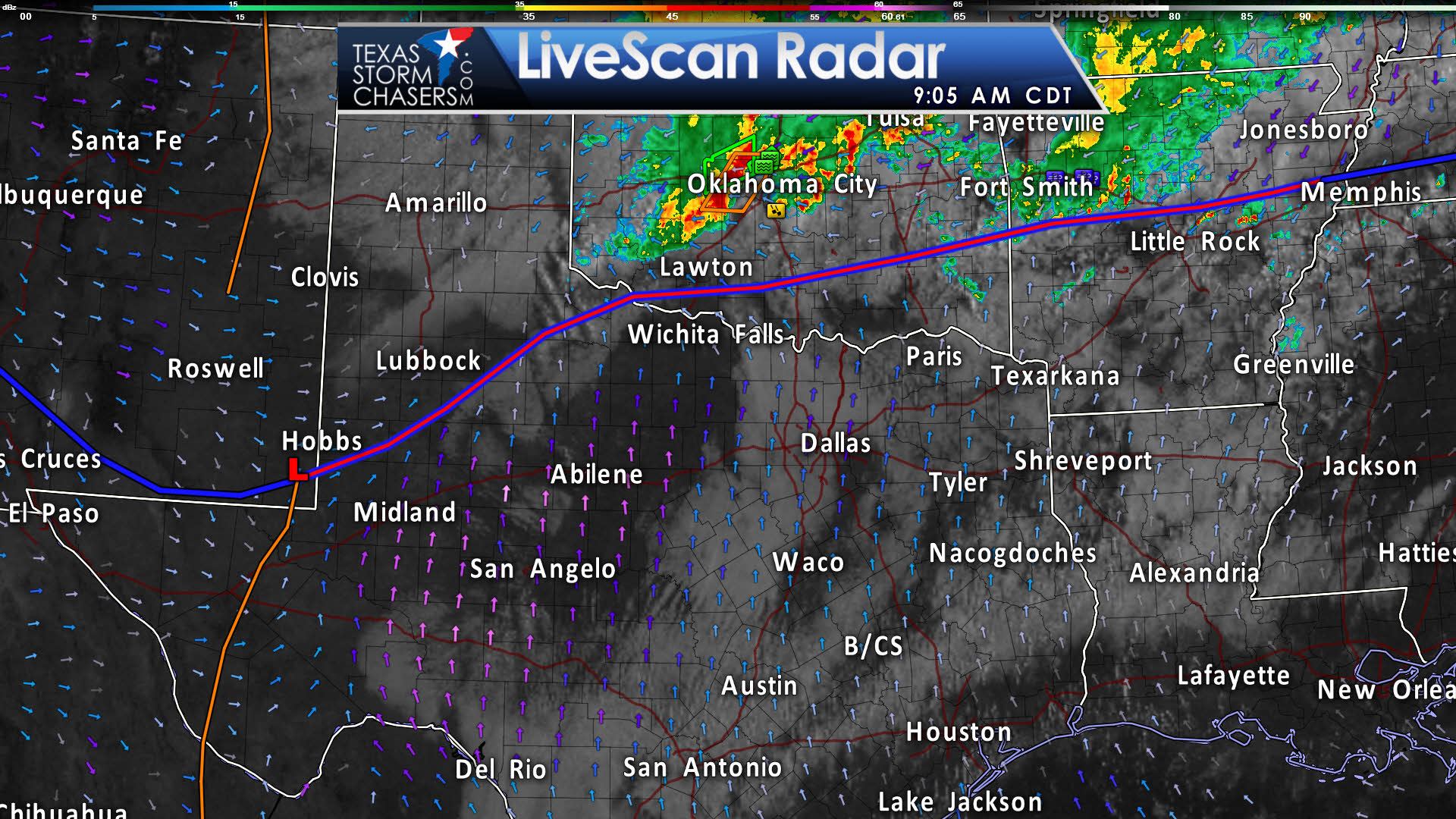
Oklahoma is rocking and rolling this morning with a cluster of severe storms moving into Oklahoma City at the time of this writing. That activity is north of a warm front located across southern Oklahoma. Activity north of that front will have the chance of producing some hail, gusty winds, and flooding. South of the front we have gusty south winds and a humid airmass across Texoma and North Texas. Low-level clouds are in place, but we expect those will tend to burn off by early afternoon. Those southerly winds will continue to pump rich moisture from the Gulf of Mexico northward throughout the day. Wind shear values will be supportive of organized thunderstorms and the atmosphere will certainly be unstable, but a question remains on the strength of the cap and how far south we’ll see organized storms today and tonight.
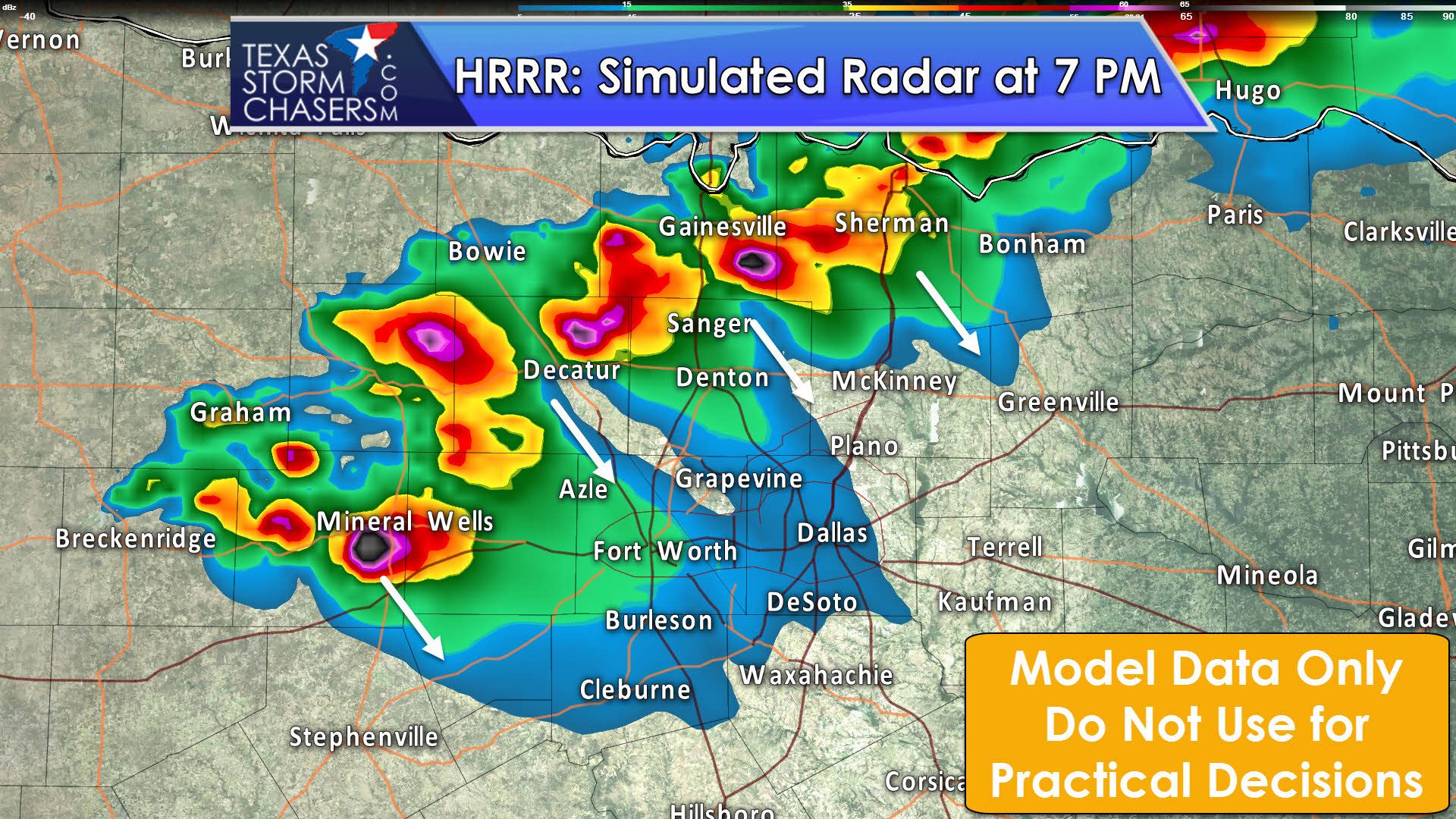
The High Resolution Rapid Refresh (HRRR) model is one of the more ambitious models with storms today. By the late afternoon hours it has a few supercells from near Gainesville to Decatur to Mineral Wells in North Texas. Other models aren’t as ambitious with storm development south of the Red River. This is going to be a day where the worst may be along and north of the Red River, or a day where we could see hailers. Obviously we’re going to be watching closely as should you. Any storm that manages to go up will likely become severe rapidly in an enviornment supportive of organized storms. The strongest storms may produce hail larger than the size of baseballs and localized wind gusts over 65 MPH. An isolated tornado cannot be ruled out, but the highest tornado threat looks to be along and north of the Red River with stronger wind shear. The highest threat for destructive hail will be with discrete/semi-discrete supercells. Once storms congeal into a squall line the threat for the destructive hail should diminish, but damaging winds and ping-pong ball size hail would remain possible.


0 Comments