
SUMMARY: We have an Elevated Risk (Level 2) of severe weather including hail, damaging winds and an isolated tornado today across western north Texas…west of the I-35 corridor. A Moderate Risk (Level 4) of severe weather including large hail, damaging winds, a few tornadoes and torrential rainfall exists beginning early tomorrow across parts of central and southeast Texas.
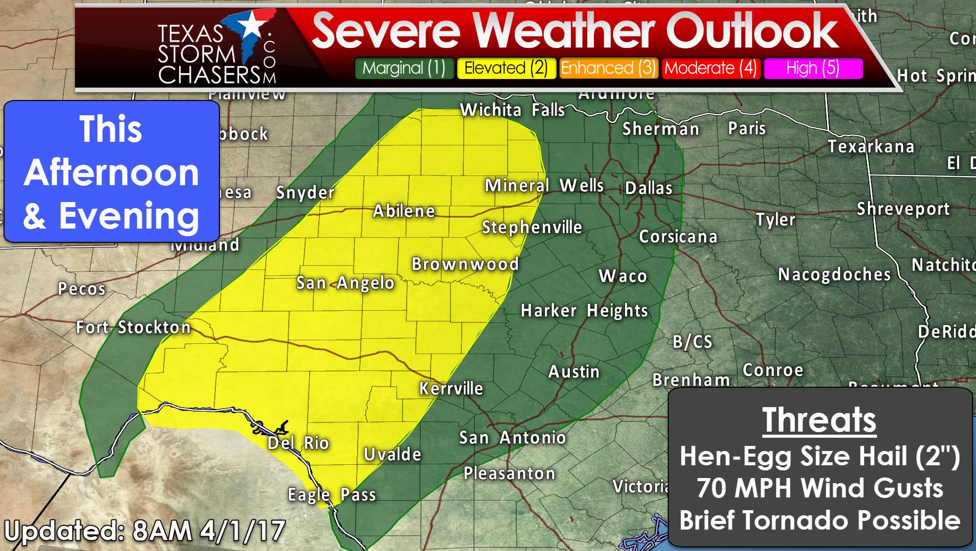
TODAY: Most of today will remain calm and storm free until we get into the afternoon hours. By mid to late afternoon, we’ll see storm begin to develop along a dryline/stalled frontal boundary which is expected to setup along or near the Hwy 83 corridor in western north Texas. Storms may initially be discrete with mainly a hail and damaging wind threat, but an isolated tornado cannot be ruled out, although the conditions this afternoon will be more favorable for damaging wind than tornadoes. These storms are expected to evolve into a linear band (squall line) and move north/northeastward into western and southern Oklahoma after nightfall and the threat of severe weather across western north Texas will then diminish. A separate area of storms are expected to develop overnight across portions of the Edwards Plateau in west central Texas (west of Austin/San Antonio) as the previously stalled frontal boundary begins to move slowly southeast into the region. This region will have the greatest potential for seeing large hail and damaging winds from embedded supercells within the cluster of storms as it advances east across west central Texas overnight and into Sunday morning. The tornado threat here is also low, but cannot be completely ruled out.
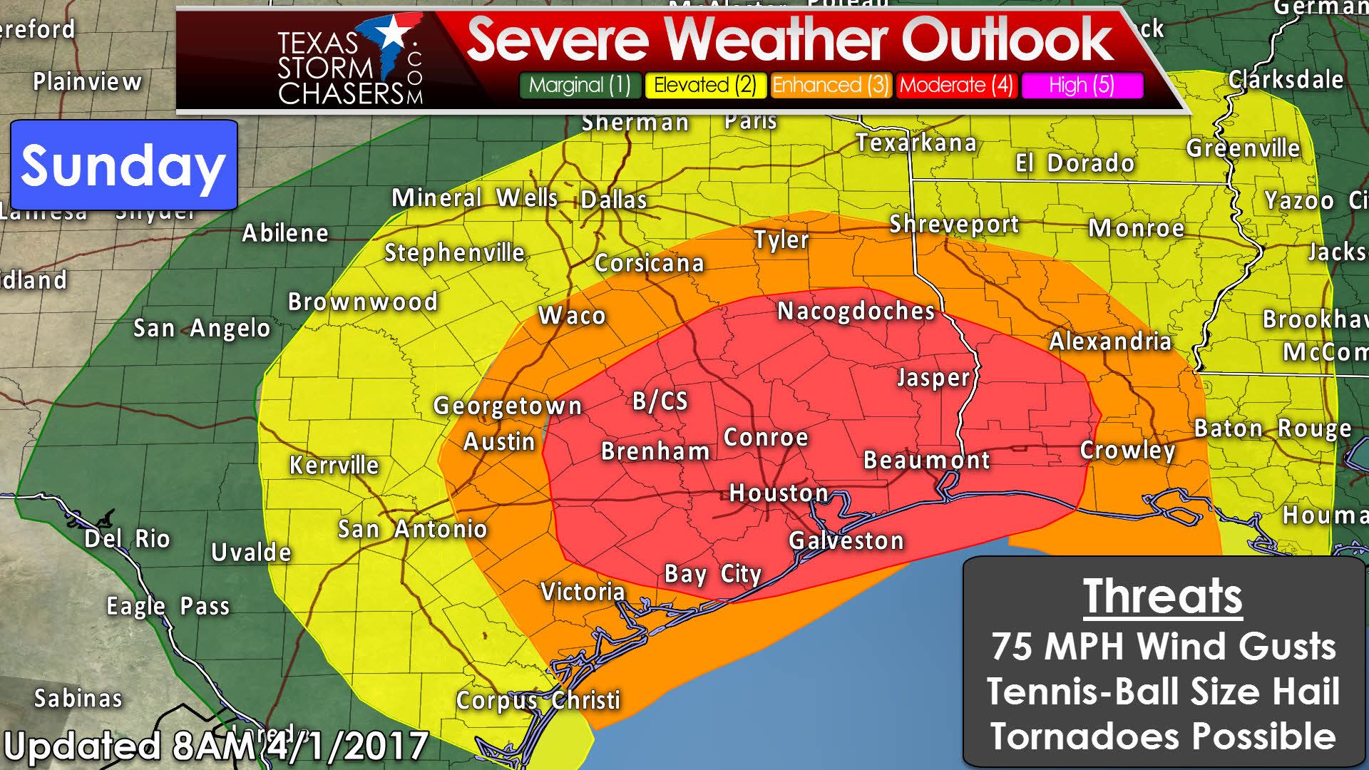
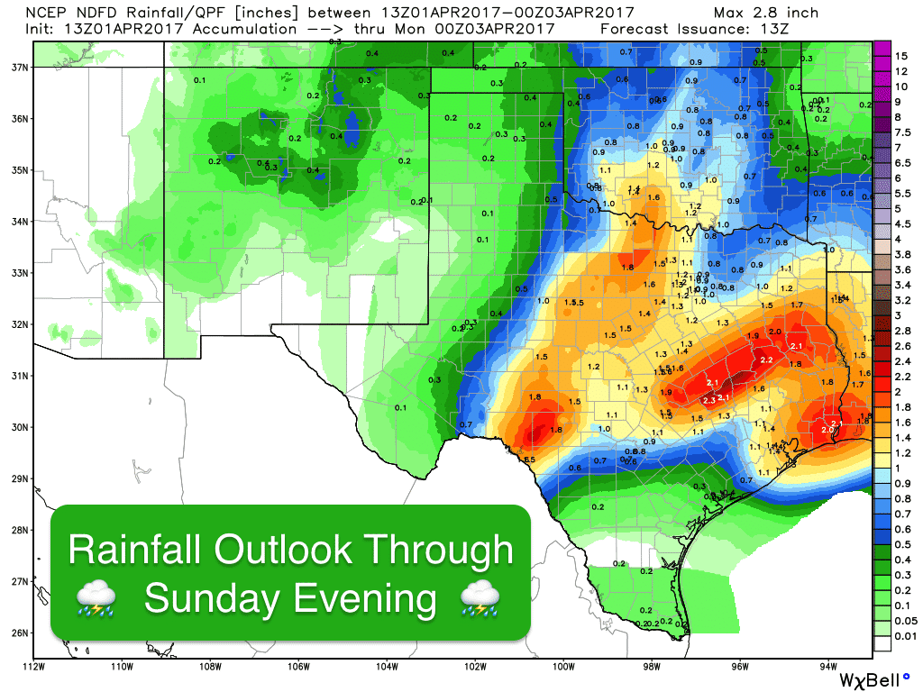
TOMORROW (SUNDAY): Strong to severe storms are expected to be ongoing into tomorrow morning across portions of central Texas…possibly beginning to evolve into a squall line as it advances east across central Texas. As the morning progresses, we’ll see increasing chances for strong to severe storm development out ahead of the advancing line of storms, some of which could be in the form of discrete supercells with the threat of very large hail and a few tornadoes…some of which could be strong. This threat will persist through the afternoon hours as the storms continue move and develop east across southeast and eastern Texas. In addition to the threat of severe storms and tornados, we’ll also see the threat of very heavy rain across most of the southeast and eastern Texas regions which will likely lead to some flooding issues tomorrow afternoon and into the evening hours. We have to mention that there are some factors which may impact the current outlook for storms across this region tomorrow. Best lift from the approaching upper level low looks to take the storm track mainly north/northwest of the Houston metro area for the most part which would mean the immediate Houston metro area may not be as greatly impacted. But…we can’t say that for sure at this time, and the forecasters at the NWS Houston/Galveston office are certainly not willing to let their guard down just yet. As the upper level low moves across the state Sunday afternoon, we could see the chance for severe storms in or just north of the Houston metro before the system moves off to the east. Again, timing of the greatest threats across the Enhanced (orange) and Moderate (Red) risk regions will be mid-Sunday morning through Sunday evening, so stay aware especially if you’re out and about. We’ll have updated information on the outlook for severe weather out later this evening and again tomorrow morning as this forecast continues to develop, so be sure to check back.
PLEASE READ: As always, when we are faced with the threat of significant severe weather, we get lots of questions such as “What’s the threat at my house in XYZ city?” Please understand that we can’t get into that level of micro-detail in the forecast, especially when it’s still a day out. All we can do is give you the forecast, the map detailing the at risk areas and it’s up to you to take it from there with your severe weather preparations. Know where you are on a map and know what county you live in, and if you are within either the Enhanced or Moderate risk area, just understand that you could see severe weather tomorrow. Is that a guarantee? No. But it’s a possibility, so make sure you have a way to receive weather warnings (NOAA Weather Radio or a smartphone App) and seek shelter immediately if Warnings are activated for your location.


0 Comments