
The threat of severe weather has come to an end across Texas. A cold front will continue to sag south tonight helping to bring a drier airmass in with it. I apologize for the lack of activity here over the last several days. Every once in a while everyone, myself included, needs to step away and take some personal time. Not only that but we completed a server transfer this morning that will hopefully speed up our website and keep us going during the busier periods. All that said we’re now back in action and looking ahead toward Friday and Saturday.

We’re still two to three days away from our next active period of weather. What I show you tonight will likely change on Thursday and Friday. This is springtime in Texas and we certainly are in an active severe weather pattern. There is no reason to be alarmed or frightened. Just like those in California have to deal with earthquakes, we have to deal with active springtime weather. Our system on Friday and Saturday will probably bring severe weather to portions of North Texas, Northeast Texas, and East Texas. How widespread the severe weather becomes and what hazards are included is still up in the air. We’ll tell you what we know and likewise explain what uncertainties we have heading toward the weekend. This blog will focus on the potential for severe weather and an attendant heavy rainfall risk. If we’re not talking about your part of Texas you should probably be happy about that.
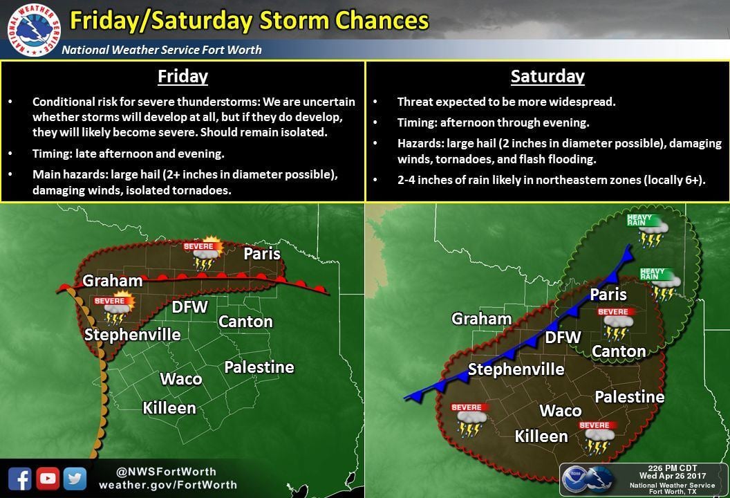
Thursday and most of Friday will be dry. The cold front pushing south tonight will stall out somewhere in South Texas and near the Coast on Thursday. By late Thursday that front will start moving north as a warm front. Impressively high moisture values will accompany that warm front as journeys north. A big question is how far north that front will be located by the late afternoon hours on Friday. Some models have the warm front near Interstate 20 in North Texas while others have it near the Red River. Those south of the warm front will experience high humidity values and gusty south winds. Those north of the warm front will be comparatively less humid, although still warm. A dryline will set up shop in the eastern Big Country to western North Texas.
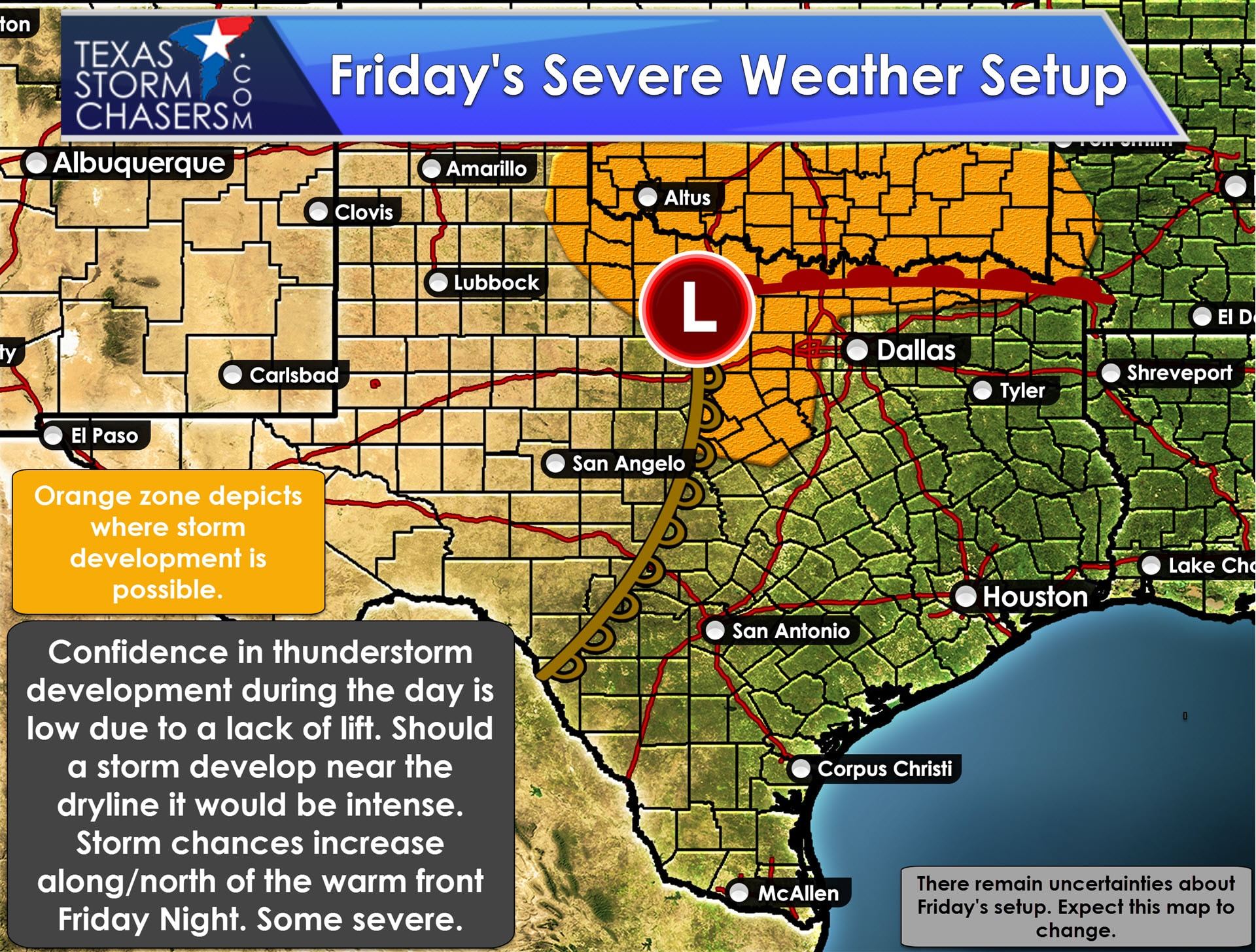
A conditional risk for isolated supercells is expected by late Friday afternoon and early Friday evening in the vicinity of the dryline and warm front in the Big Country, Northwest Texas, and western North Texas. The actual placement of those features will dictate where the conditional severe weather risk eventually is come Friday. The cap won’t be all that strong and the enviornment will be extremely unstable. Wind shear values look to be supportive of organized thunderstorms, although models do disagree on how much low level shear will be available at the onset. The caveat on a more significant/certain severe weather threat is that we won’t really have much in the way of lift in place. Sure, the cap is weak, but that doesn’t do much if we don’t have the lift necessary to develop storms. This will be a day where localized features such as a dryline bulge (where a small part of the dryline surges east), or other factors may play a role in where one or two supercells fire up. It is entirely possible we get through sunset with no storms should a lift source not materialize. Any thunderstorm that does manage to develop will for the lack of a better phrase, blow up like a bomb. It will very quickly become severe with a threat of hail larger than the size of baseballs, localized damaging wind gusts, and the potential of being tornadic. That risk is conditional on there actually being storms in the first place. If we don’t have storms then we can’t very well have severe weather, can we! Regardless this does not seem to be a widespread severe weather threat at the moment. Details will become more clear as we get within 24 hours of late Friday afternoon/evening, so check back for updates to the forecast on Thursday.

Saturday is shaping up to be ‘the day’ where we could be dealing with widespread thunderstorm potential. Being 72+ hours out means there are more questions than not at this stage in terms of the mesoscale (localized) enviornment. The overall setup does seem to favor the possibility of numerous thunderstorms – some being severe. We may have to deal with a squall line that moves from west to east across the risk zones. Specific timing and locations impacted will depend on where features setup. Unlike Friday we will definitely have a strong source of lift with a cold front moving into the affected regions. The highest risk of severe storms currently appears to be from North and Central Texas eastward into Northeast Teas, East Texas, the Brazos Valley, to northern Southeast Texas. As is usual the threat of severe weather will decrease closer to the coast and into South Texas thanks to most of the upper level lift passing to the north. A squall line would have the potential of producing hail up to the size of golfballs, damaging straight-line winds over 70 MPH, and brief tornadoes. Should we see any discrete storms the potential for tornadoes would definitely exsist based off the current forecasted instability/shear combination. Refinements are probable as we get closer to Saturday and the entire picture comes into view. Nevertheless a fairly good chance of storms is expected. You can get Your Local Forecast and rain chances here.
Last but not least is the chance of heavy rainfall and localized flash flooding. Rainfall amounts of 2 to 4 inches are expected on Saturday-Sunday in Northeast Texas and parts of East Texas. Localized amounts may approach 6 inches. Our neighbors in western and northwestern Arkansas may be dealing with 8-10 inches of rain. Some flooding threat is expected, but like the severe weather potential, will all depend on how everything comes together in the next few days.


0 Comments