
These simulated radar graphics are meant to convey a relative sense of timing on when storms may be impacting your location. Please keep in mind these are from one model, and that one model probably doesn’t have it all right. Don’t expect the radar to look exactly like what is depicted – in either locations or exact times. While the line or complex of storms depicted here may be fairly accurate, the location/timing/number of discrete storms ahead of it may not be picked up by any model. That’s why the time window for storms will be rather large. Multiple rounds of storms may impact one location.
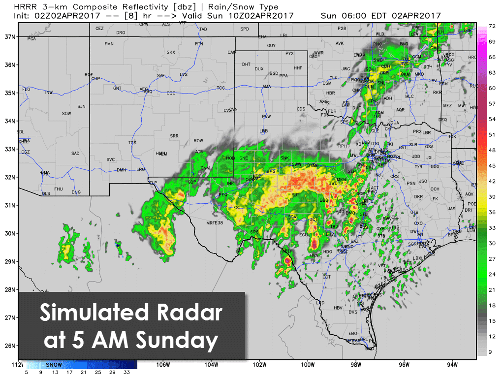
At 5 AM the HRRR has multiple discrete/semi-discrete storms underway across the Edwards Plateau into the Hill Country and Central Texas. Some of these will likely be severe with large hail, damaging winds, and a threat for a couple of tornadoes. The atmosphere will become more favorable for severe weather as we go into the night, even though it’s nighttime. Those discrete storms near I-35 are concerning – as the enviornment will be supportive of tornadoes. Storms will also be approaching the D/FW Metroplex further north – where some storms may be capable of producing hail and localized gusty winds.
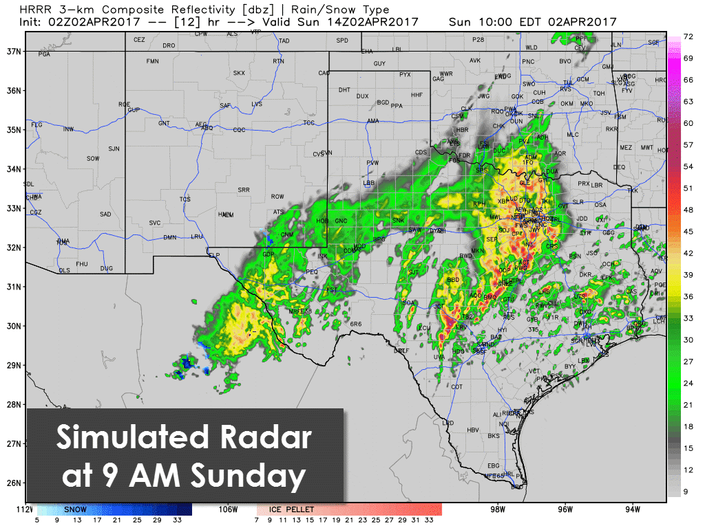
By 9 AM storm coverage and intensity will likely have increased. Discrete supercells capable of producing tornadoes may be underway in Southeast Texas and the Brazos Valley. Further west, several strong to severe storms should be underway in the Hill Country and Central Texas. Heavy rain and some strong storms will be occuring further north in North Texas and the D/FW Metroplex. Damaging winds, hail, and some tornado threat is the concern with the complex/squall line. Discrete storms ahead of the line – or embedded supercells in the complex – may be capable of producing significant tornadoes. Please don’t let the time of morning fool you, the atmosphere will be very supportive of significant severe weather. Whether or not we have one tornado or many tornadoes will depend on how everything sets up.
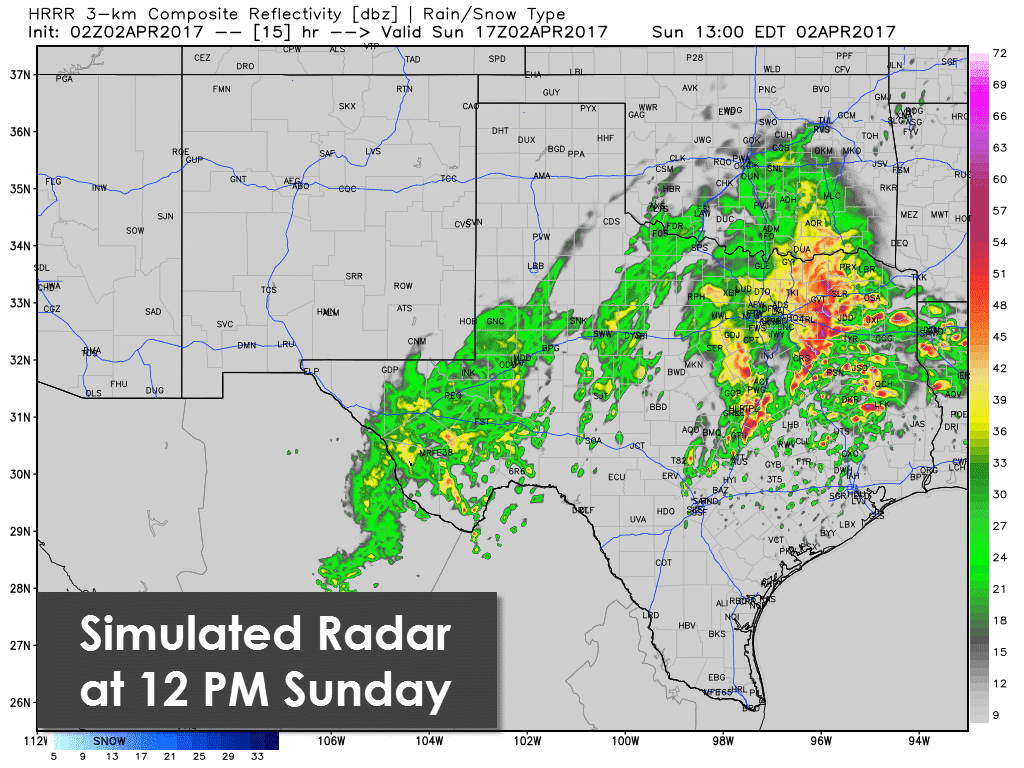
By noon multiple supercells may be underway in East Texas into Southeast Texas – with a threat of strong tornadoes. A complex or squall line with widespread damaging wind potential along with hail and tornadoes may be moving into eastern North Texas, extending southward into Central Texas. We’ll likely be quite busy in this timeframe – and again, the atmosphere will be capable of significant severe weather. While this one model isn’t showing much going on around Houston at this point, the atmosphere will be primed for big issues if we get any storms going there.
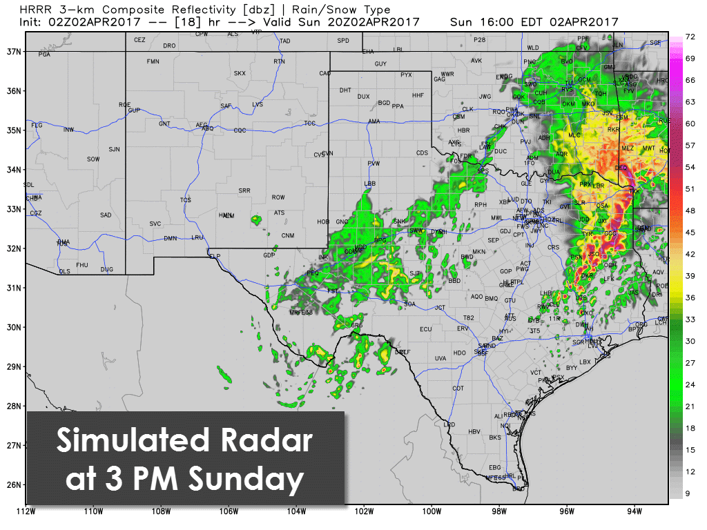
By 3 PM a squall line with large hail, widespread damaging winds, and possible tornadoes looks to be moving into Southeast Arkansas into East Texas. We’ll still have to watch for discrete storms ahead of that line – and further southwest into Southeast Texas.
The next severe weather outlook from the Storm Prediction Center will be issued around 1 AM Sunday. I wouldn’t be surprised if they extended the level four risk northward a bit. Depending on how things look to come together, a small level 5 (high risk) may be issued at some point. Regardless, tomorrow features a significant severe weather risk. You need to have ways of receiving severe weather warnings, and that doesn’t include outdoor warning sirens. We’ve got an article put together here with tips, including great smartphone apps.


0 Comments