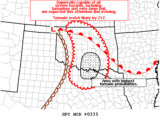
The forecast remains on track this afternoon, with moisture continuing to stream northward ahead of the dryline. The Storm Prediction Center has indicated that a tornado watch will be issued by 4-5PM for Texoma and portions of North Texas. Thunderstorm initiation is probable by 5-6PM near the Red River. This development will explosively intensify and become severe quickly. Storms will move off to the east/northeast. By early evening, additional isolated thunderstorm development may occur further south on the dryline, which will be located just west of the DFW Metroplex. The highest chance of a storm will be along and north of Highway 380, but cannot be ruled out north of Interstate 20. Any storm that develops has a good chance of being severe with a risk of very large hail up to the size of baseballs, damaging wind gusts over 70 MPH, and potentially a few tornadoes. The threat for tornadoes will increase after 7 PM as low level winds become more favorable. The severe weather threat could continue into the late evening hours.
Mesoscale Discussion 0335
   NWS Storm Prediction Center Norman OK
   0249 PM CDT Sun Mar 26 2017

   Areas affected...Central/Northeast OK...North-Central TX

   Concerning...Severe potential...Tornado Watch likely

   Valid 261949Z - 262115Z

   Probability of Watch Issuance...95 percent

   SUMMARY...Supercell thunderstorms capable of all severe hazards,
   including tornadoes and very large hail, are expected across
   portions of central OK and north-central TX this afternoon and
   evening. A tornado watch will likely be needed by 21Z.

   DISCUSSION...Recent surface analysis shows a low centered just
   northwest of GAG with a dryline arcing southeastward to just west of
   CSM and then southwestward through FDR (in southwest OK) and ABI (in
   the low rolling plains of TX).  A warm front also extends from this
   low eastward/southeastward from GAG to END to CUH and on into
   southeast OK. Low-level moisture continues to advect northward in
   the warm sector between the dryline and warm front, with 60 degree F
   dewpoints as far north as Love, Carter, and Marshall counties in far
   south-central OK. Mid-50 degree F dewpoints extend as far north as
   Caddo, Grady, and McClain counties. Given the filtered sun across
   the region, some modest mixing is possible but dewpoints are still
   expected to range from the mid-50s to low 60s from central OK
   southward into north-central TX. This low-level moisture coupled
   with steep mid-level lapse rates will result in moderate instability
   (i.e. MLCAPE from 1500 to 2000 J/kg) by 21Z ahead of the approaching
   dryline.

   Visible satellite imagery continues to show agitated cumulus beneath
   the mid/high-level cloud band with some towering cumulus also noted
   near the western edge of the cloud band, close to current position
   of the dryline. The western edge of the cloud band also likely
   represents the leading edge of strong forcing for ascent associated
   with the approaching shortwave trough. As such, the current thinking
   is that convective initiation will occur as the dryline and stronger
   forcing for ascent interacts with the destabilizing airmass across
   central OK around 21Z. Favorable kinematic profiles characterized by
   0-6 km bulk shear near 50 kt will support quick storm organization,
   resulting in supercells capable of all severe hazards including
   tornadoes. Additionally, low-level jet increase around 00Z will
   lengthen hodographs in the presence of ongoing storms, resulting in
   a locally higher threat for tornadoes from south-central OK into
   northern portions of north-central TX.

   Somewhat different scenario will lead to the chance of a few
   tornadoes farther north within the marginally moist environment
   across north-central OK and possibly into far south-central KS.
   Here, some severe threat, including tornadoes, is possible as storms
   interact with the warm front draped across the region.

   ..Mosier/Guyer.. 03/26/2017


0 Comments