
The Storm Prediction Center is forecasting another active period of severe weather potential over the next two days. Remember that thunderstorms don’t care about which outlook category they’re in and that there’s always a surprise or two thrown into the event. That’s why keeping an eye on the sky and checking back for updates throughout the day are both good pieces of advice.
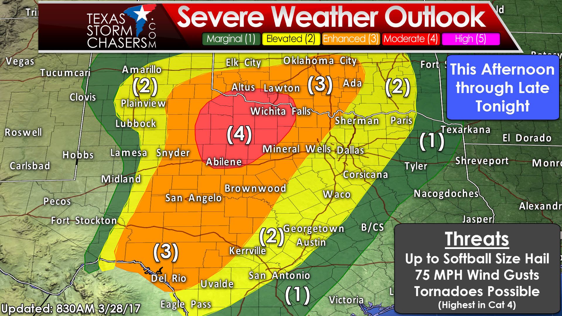
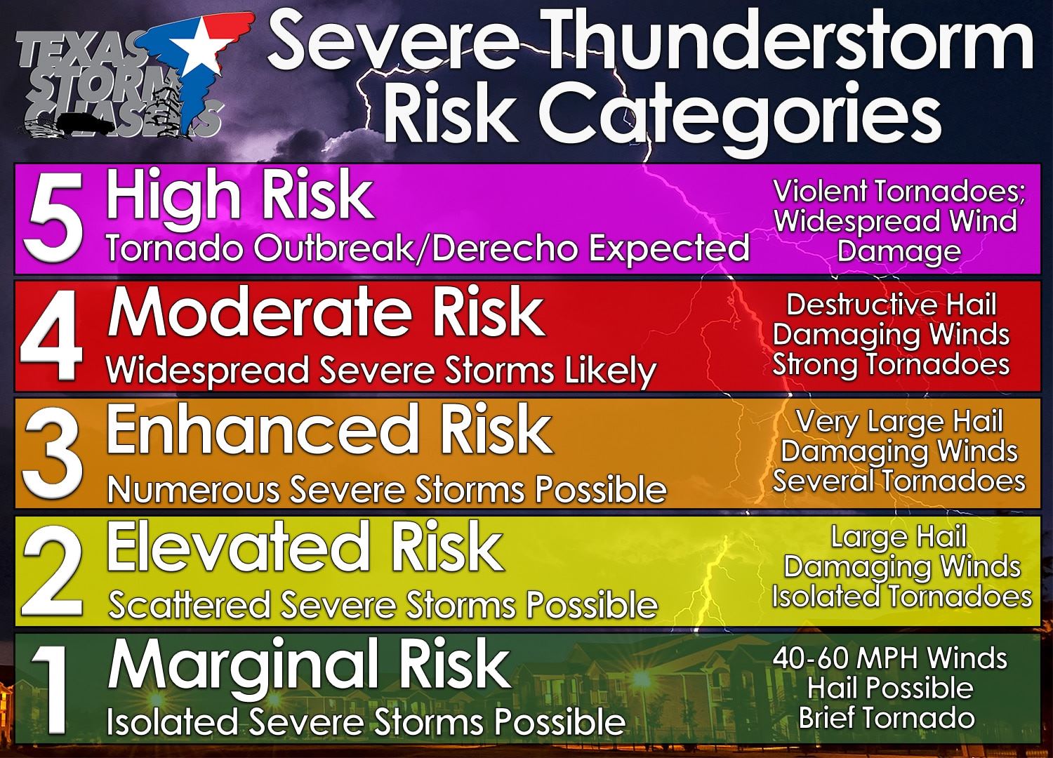
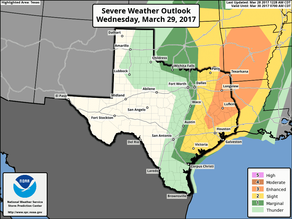
We now have a category four risk of severe weather across Northwest Texas and northern sections of the Big Country. This upgrade has been issued due to the likelihood of several severe storms capable of producing very large hail up to the size of softballs, damaging wind gusts over 70 MPH, and a couple of tornadoes. The significance of the tornado threat will depend on if storms remain discrete or quickly form up into a squall line. A squall line would lessen the threat for tornadoes, while a discrete/semi-discrete storm mode would have a higher risk of producing tornadoes, including the potential for a strong tornado. A category three risk runs from Southwest Texas, including Del Rio, northeast through the Concho Valley, western Hill Country, Big Country, West-Central Texas, and western North Texas. This zone is where there’s roughly a one in three chance of a location experiencing severe weather within twenty five miles. A category two risk, the standard risk level for severe weather outlooks, runs east to a San Antonio to Bastrop to Corsicana to Paris line. This risk is for the evening and overnight hours, into pre-dawn Wednesday, as a squall line moves east with damaging wind and hail potential. A category two risk also includes the eastern half of the Texas Panhandle where large hail is possible this afternoon and evening.

By the mid-afternoon we could have a fairly widespread area of rain underway across the eastern Texas Panhandle. This would be in a fairly stable airmass, but some hail could occur. Further south and east we’ll be dealing with a warm front near the Red River (exact position still to be determined later on). North of the front, conditions would be favorable for large hail. South of the front, conditions would be favorable for large hail, damaging winds, and a tornado threat. The strongest discrete storms could be tornadic in Northwest Texas and the Big Country, while more linear storms (in a line) would have a large hail and damaging wind risk.
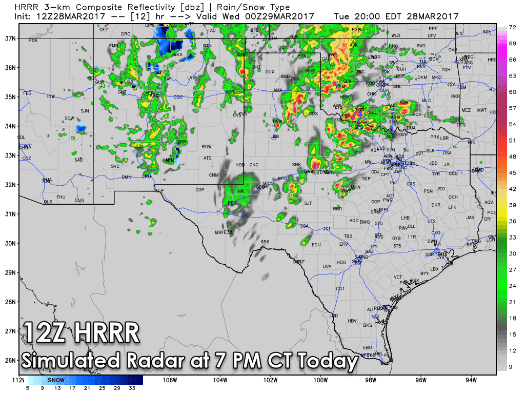
By the early evening its likely we’ll have numerous storms underway in Northwest Texas, the eastern Texas Panhandle, and the Big Country. Some of these will be severe with a risk of very large hail and damaging wind gusts. The significance of the tornado threat will depend on storm mode. Linear storms would have a lower tornado threat and higher damaging wind threat, while discrete storms could have a more substantial tornado risk. The position of the warm front will also dictate where any localized significant tornado threat may develop. At this point its expected to be near the Red River in Northwest Texas, so we’ll have to keep a close eye on it. Remember, these model graphics are simply projections. They won’t get it completely right and we’ll probably have a surprise or two later today.
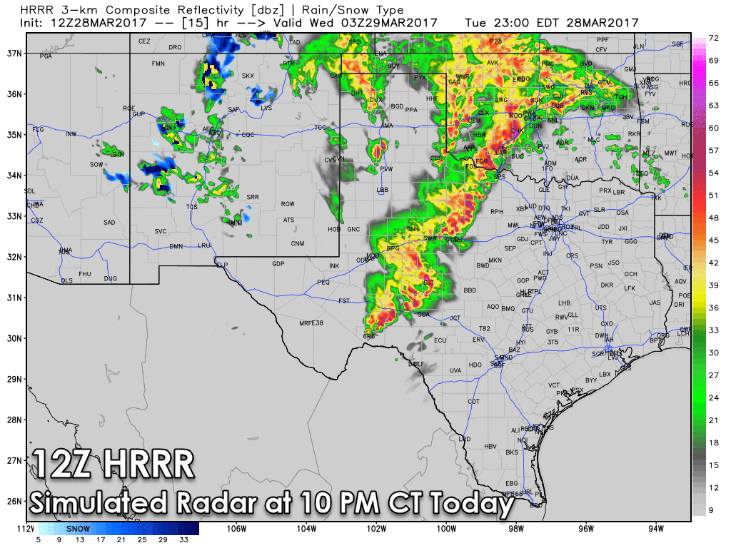
By the mid-evening a squall line should be underway and moving east in Northwest Texas, the Big Country, and into the Concho Valley. Some of these storms will be severe with large hail, damaging winds, heavy rains, and a low-end risk for brief tornadoes. This squall line will continue to move east late tonight and into the day Wednesday with a risk of damaging wind gusts. Right now, it looks like it should be after midnight and into early Wednesday for the I-35 corridor from San Antonio north/northeast to D/FW.
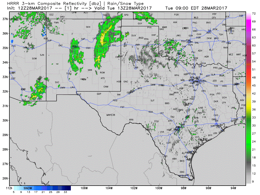
Here’s a loop of the HRRR’s simulated radar through tonight. Keep in mind this model won’t get it all completely right. Timing and locations could be off, so keep checking back and keep an eye to the sky.
The risk for severe weather will continue on Wednesday in eastern North Texas, Northeast Texas, East Texas, Southeast Texas, the Middle Coast, and the Brazos Valley. The squall line tonight will continue to push east during the morning hours Wednesday with a threat of damaging winds and hail. A second round of more isolated, yet potentially more significant severe storms may develop just east of a dryline Wednesday afternoon. That dryline would be located just east or east of Interstate 35. We’ll deal with this conditional afternoon round after we get through today, since several things will have to go right for the additional afternoon risk of severe weather to develop. Yet, if it does, there is the potential for very large hail, damaging wind gusts, and a tornado threat to develop.


0 Comments