
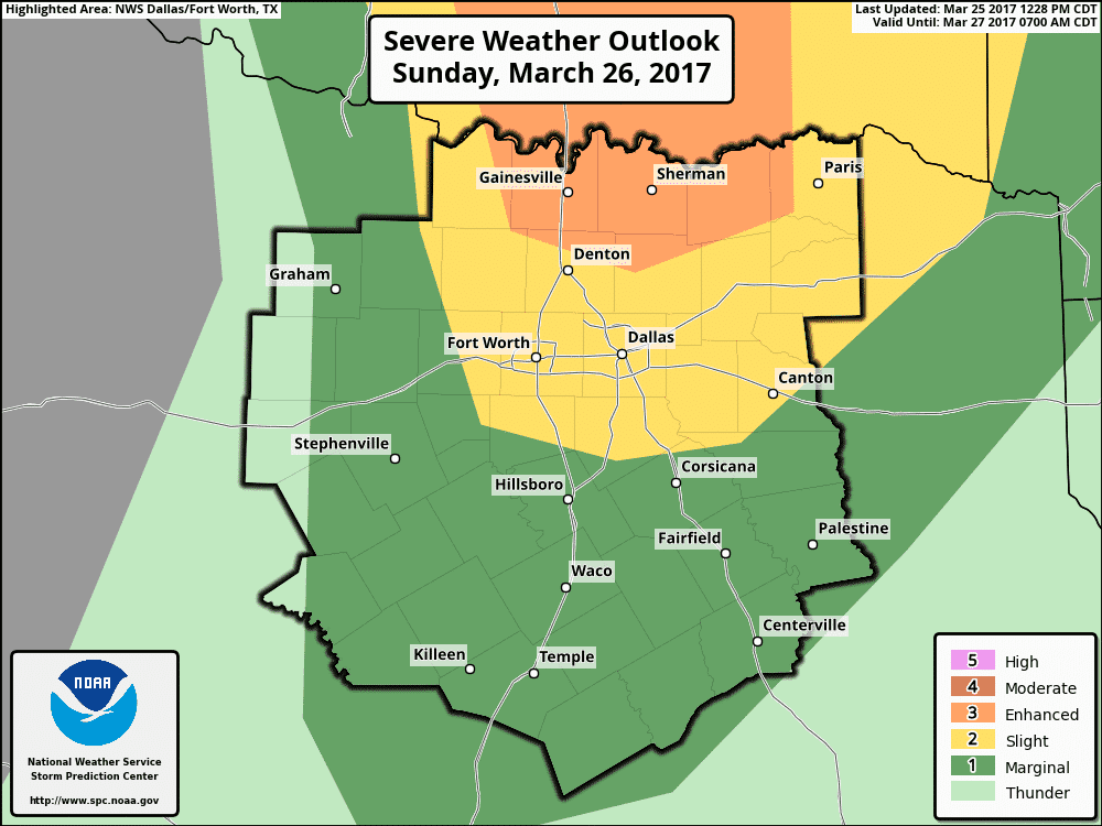
The possibility of severe weather on Sunday is highly conditional. The Storm Prediction Center have placed a category three risk of severe weather runs north of a line from St. Jo to Celina to Honey Grove. A category two risk of severe weather runs from Henrietta south to near Interstate 20 from Weatherford to Canton, northeast to New Boston. Tomorrow is going to be a day where the outlook ‘lines’ won’t matter as much as where we can actually break the cap. Depending on where the cap looks likely to break, the severe weather outlooks will have to be adjusted accordingly. It isn’t an easy forecast.
Yesterday’s cold front pushed the more moisture-rich environment toward the coastline. Southeast winds tonight and during the day Sunday will work to bring 55+ degree dew points back north. There remain questions on the overall quality/depth (how much moisture) will be available for storms in North Texas into Oklahoma by late tomorrow afternoon. Another uncertainty is how far south the ‘cap’ will break and allow explosive thunderstorm development. Some models keep a majority of the storms north of the Red River, while a few others show isolated storms breaking out ahead of the dry line all the way down to Interstate 20. It is certainly possible that the cap holds in North Texas tomorrow, its possible we may have one or two storms, and to a lesser extent, its possible we have scattered storms.

Any thunderstorm that is able to break the cap and sustain itself will likely become severe. The amount of wind shear and projected instability values in Texoma and northern sections of North Texas certainly would support severe weather. The primary question is how much moisture will be available. If dew points remain in the upper 50s, the tornado risk would be low (not zero). If we get dewpoints to 61-62 degrees in the thunderstorm’s environment then the potential for tornadoes would become more significant. This will be a case, if we’re able to get storms to fire, where a few degrees in the dew point will dictate whether or not we’re dealing with tornadic supercell potential. Either way, very large hail larger than the size of baseballs would be expected with any supercell that can develop. That’s a pretty good bet regardless of upper 50 or lower 60 degree dewpoints. The higher the dew point value, the lower the cloud bases can become. We’ll be watching trends closely.
Any storms that do manage to develop would likely start weakening not long after sunset as the cap quickly becomes nuclear. That may not be the case north of the Red River where a number of severe storms are possible tomorrow. I encourage you to check back for forecast updates on Sunday. If confidence increases in the strength of the cap, we’ll be able to start backing off the potential for severe storms. If confidence in storm imitation increases, so will our concern for damaging hail-storms. Welcome to Spring folks, these kind of threats aren’t unusual.


0 Comments