
We remain in a very busy weather pattern through the end of March and into the first week of April. With that said, we’re going to focus on one event at a time. Now that we’ve gotten through Sunday’s setup, we will now focus on the potential severe weather event expected tomorrow (Tuesday) and on Wednesday. As yesterday demonstrated, the strength of the cap will play a big role in how far south or how many storms we deal with. The cap ended up being a tad weaker yesterday than anticipated, so we had storms ‘unzip’ down the dryline into Central Texas. Keep that in mind when we’re talking about future events. Just like winter weather in Texas, there’s always a surprise or two with severe weather. With all those disclaimers out of the way, lets dive into it!
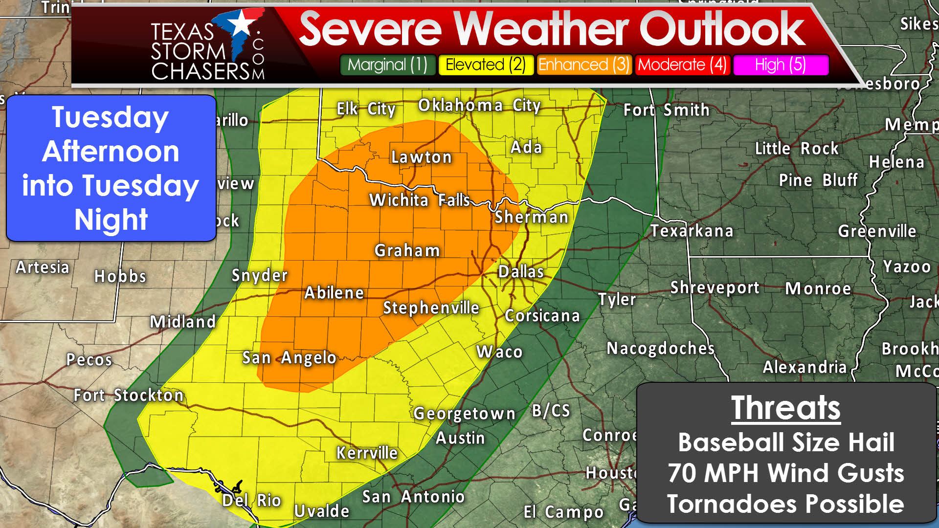
The Storm Prediction Center has placed a category three (enhanced) risk of severe weather for tomorrow in Northwest Texas, the Big Country, Concho Valley, and the northwestern half of North Texas. San Angelo, Abilene, Graham, Vernon, Wichita Falls, Gainesville, Denton, Weatherford, and Stephenville are a few cities in this risk zone. The standard category two risk includes the eastern Texas Panhandle, portions of West-Central Texas, into Southwest Texas, the remainder of North Texas, the Hill Country, and western portions of Central Texas. Shamrock, Snyder, Ozona, Junction, Del Rio, Kerrville, Burnet, Killeen, Hillsboro, Dallas, Sherman, and Bonham are a few cities included in the standard category two risk. A category one risk does run just east of the category two zone, but this is for the end of the ‘Day 1’ outlook. Most of these locations are in a category two risk area for Wednesday.
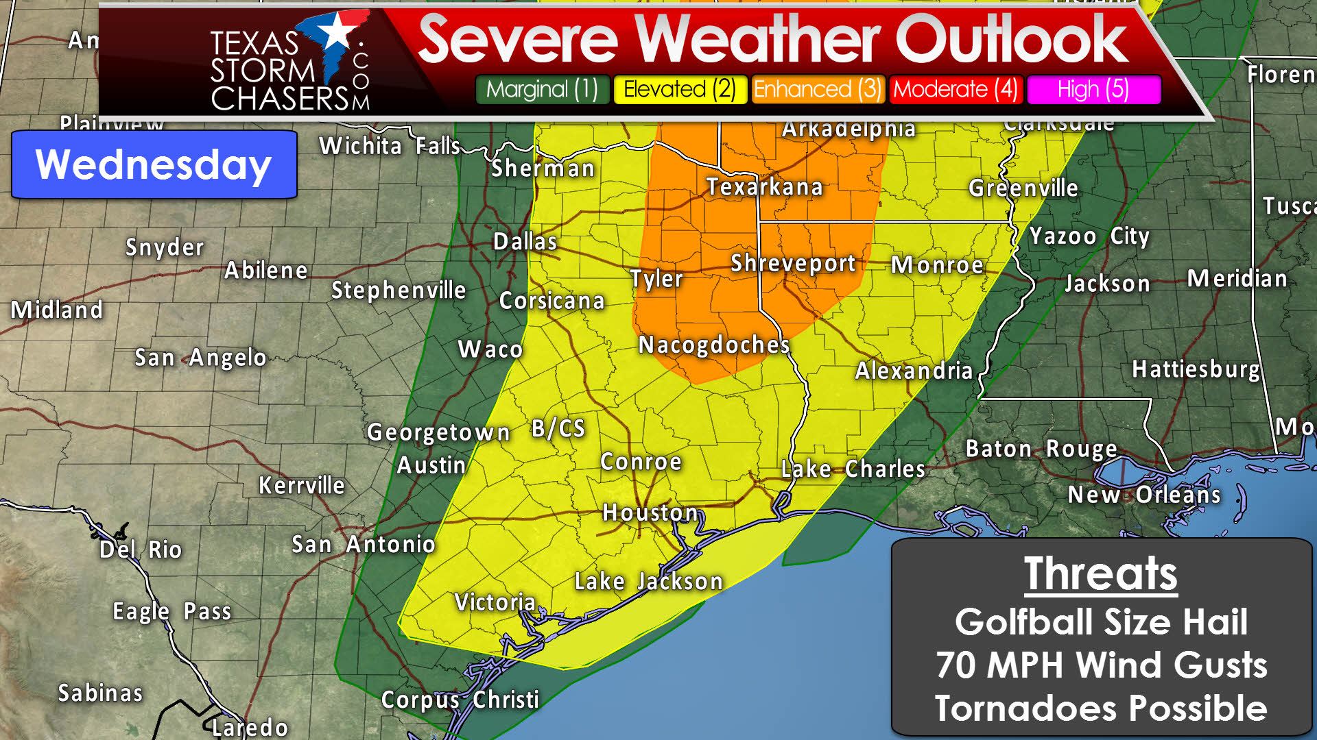
For Wednesday the folks at SPC have already placed a category three (enhanced) risk in Northeast Texas and East Texas. New Boston, Tyler, Nacogdoches, Longview, to Texarkana are a few towns included in the Cat. 3 risk. A category two risk runs along and east of the Cat 2. in Tuesday’s outlook and all the way into Arkansas and Louisiana. Victoria, Houston, B/CS, Conroe, Corsicana, Lufkin, Jasper, and Beaumont are all included in the Cat 2 risk. Expect changes to the outlook areas in subsequent updates as tomorrow’s convective evolution will help play a part in where the highest severe weather chances materialize on Wednesday.
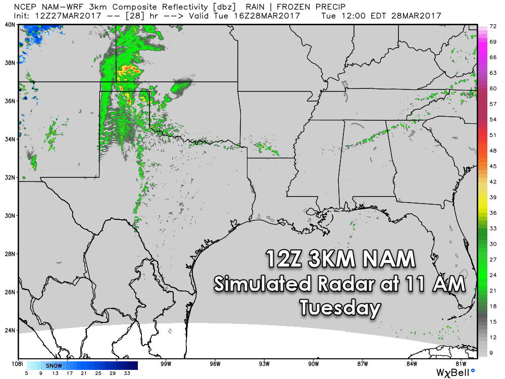
Widespread rain with a few embedded storms are possible Tuesday morning in the Texas Panhandle, West Texas, extending into portions of Northwest Texas and Western Oklahoma. This activity is not expected to be severe, but should provide some rains to areas that really need it. The evolution of this morning convection will play a critical role in the afternoon setup for severe weather. The rain-shield may help reduce the northern extent of the severe weather risk, but that’s something we simply won’t know until late tonight or more likely the morning hours tomorrow.

By the afternoon hours the widespread precipitation in the Texas Panhandle, at least according to this one model, will have cleared out. In its wake we now have strong storms breaking out in the Texas Panhandle eastward into Oklahoma. I’d like to point your attention to the one little-looking cell south/southwest of Vernon. Those are the kind of cells we’ll have to be very wary of tomorrow afternoon. Ingredients look to be favorable for tornadoes in the Big Country north into Northwest Texas. That would be the kind of cell that would have a high chance of producing significant severe weather, including giant hail and possibly tornadoes. I don’t think the radar will look exactly like this tomorrow afternoon, but you get the general idea. Also, I’m not sure we won’t have storm development underway further south into the Big Country and Concho Valley. It’ll all depend on how the widespread rain/storms impact the setup tomorrow, but like yesterday, I think we may have storms going on further south than what this model shows.

By the late evening hours Tuesday a squall line should be underway in portions of Northwest Texas, the Big Country, Concho Valley, and perhaps even into North Texas. Timing could still change by a few hours, either faster or perhaps a bit slower (like this model shows). Just don’t be surprised if that line of storms ends up further east by 10 PM than what is shown above. The primary severe weather threat with a squall line would be damaging straight-line winds up to 70 MPH, hail up to the size of quarters, and brief tornadoes. The sustained threat for tornadoes would be highest with any discrete storms still underway. Some storms may still be impacting the Texas Panhandle as well tomorrow evening, those could contain high winds and hail.
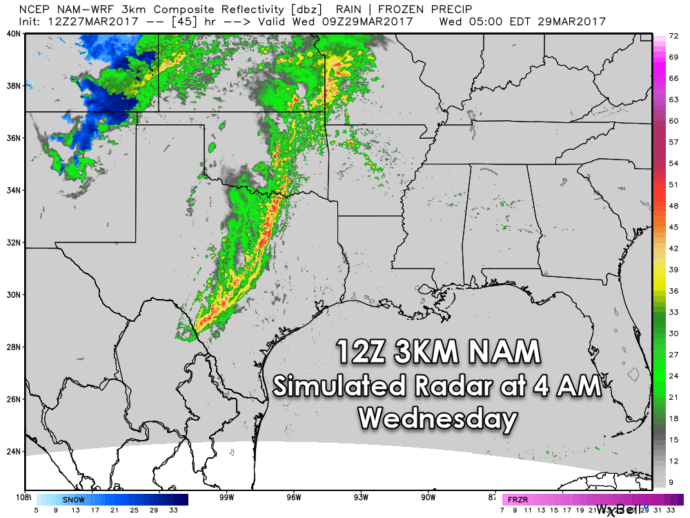
By early Wednesday morning this model has a squall line approaching Interstate 35 from the Red River south to San Antonio, all the way southwest to Del Rio. Some storms in this line would likely still be potent with damaging straight-line winds up to 65 MPH and hail up to the size of quarters. The tornado threat would be low, but a brief spinup couldn’t be ruled out in enhanced parts of the squall line. It would be moving east at 30 to 40 MPH most likely.
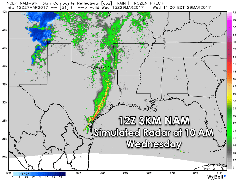
By late morning Wednesday the line would be in a weakened state, but still moving east across Northeast Texas, East Texas, and Southeast Texas, down into the Middle Coast. We’ll have to watch for some severe weather potential with southern sections of the squall line since that airmass will be unstable. The primary threats would be large hail up to the size of half-dollars and gusty straight-line winds.

Finally, after that line dissipates or at least moves east, a second round of convection may develop just east of a dryline during the late afternoon hours Wednesday. This model indicates that across Northeast Texas, East Texas, into the Brazos Valley, and Southeast Texas. This is all very conditional on the atmosphere being able to destabilize behind the first line of storms Wednesday morning. If that happens, we could indeed see more severe weather develop Wednesday afternoon and Wednesday evening. Very large hail, localized damaging wind gusts, and at least some risk for tornadoes would exsist with the strongest storms. We’ll deal with this potential on Wednesday, since we still need to get through Tuesday and Wednesday morning first.
These risks are not unusual or by any means rare in Texas. Its our spring tornado season, and that does start in March. Make sure you and your family have a severe weather safety plan and way to receive severe weather warnings. We’ve got a great list of tips posted here.


0 Comments