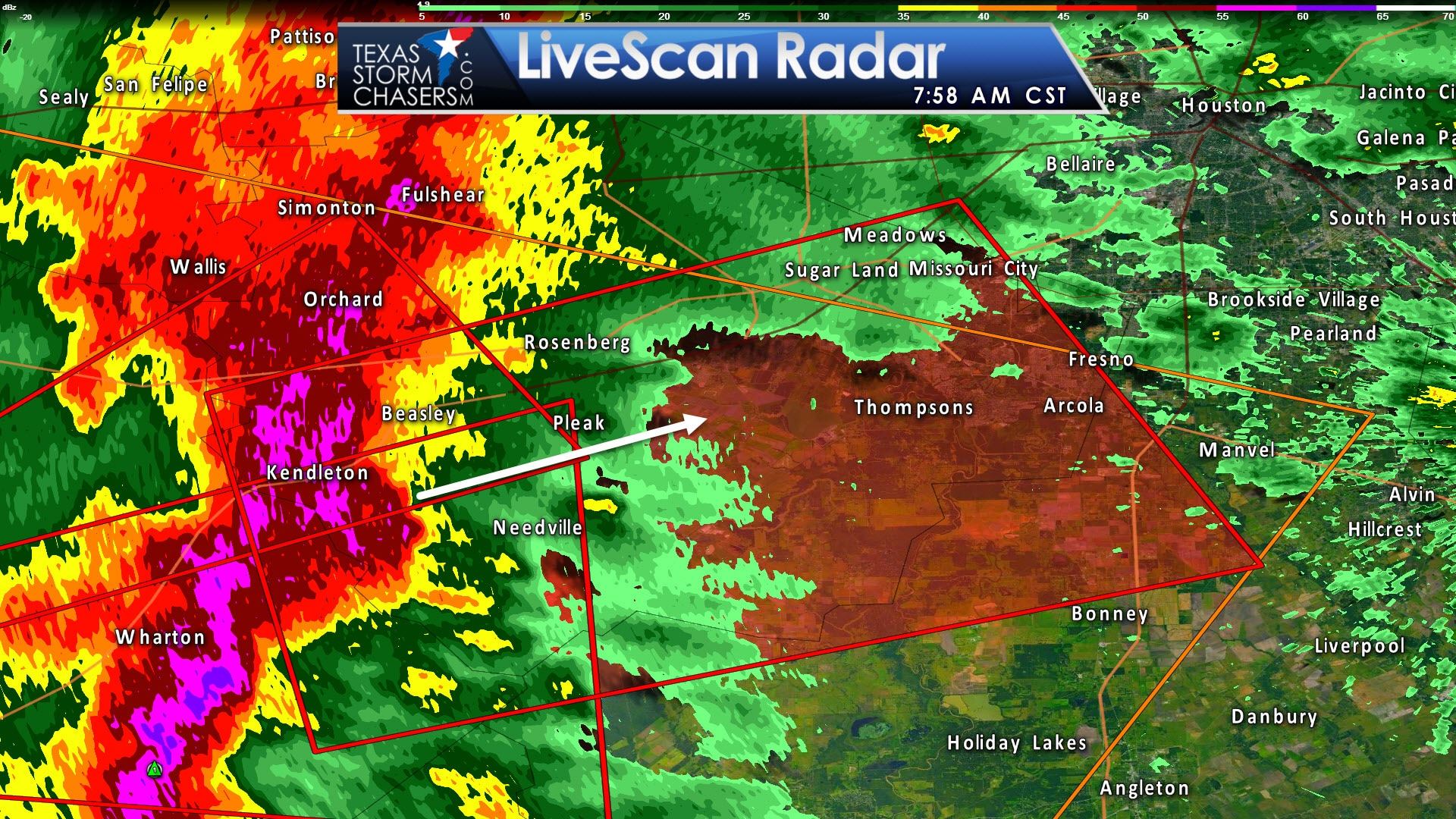
Tornado warning for northeastern Wharton, northwestern Brazoria, southern Harris, and Fort Bend Counties in Southeast Texas until 845AM. Possible tornado is located near Kendleton or Wharton. This thing is rain-wrapped and you won’t see a thing until its on top of you. Storm is moving east/northeast at 30 MPH. Cities in this warning that should move to tornado-safe place include Sugar Land, Missouri City, Rosenberg, Stafford, Richmond, southwestern Manvel, Fresno, First Colony, Pecan Grove, Meadows Place, Needville, East Bernard, Arcola, Iowa Colony, Pleak, Fairchilds, Beasley, Kendleton, Thompsons and Brazos Bend State Park.
Tornado Warning
National Weather Service Houston/Galveston TX
755 AM CST TUE FEB 14 2017
The National Weather Service in League City has issued a
* Tornado Warning for…
Northeastern Wharton County in southeastern Texas…
Northwestern Brazoria County in southeastern Texas…
South central Harris County in southeastern Texas…
Fort Bend County in southeastern Texas…
* Until 845 AM CST.
* At 754 AM CST, a severe thunderstorm capable of producing a tornado
was located near Kendleton, or near Wharton, moving east at 30 mph.
HAZARD…Tornado.
SOURCE…Radar indicated rotation.
IMPACT…Flying debris will be dangerous to those caught without
shelter. Mobile homes will be damaged or destroyed.
Damage to roofs, windows, and vehicles will occur. Tree
damage is likely. Valentines day tents may be upended.
* Locations impacted include…
Sugar Land, Missouri City, Rosenberg, Stafford, Richmond,
southwestern Manvel, Fresno, First Colony, Pecan Grove, Meadows
Place, Needville, East Bernard, Arcola, Iowa Colony, Pleak,
Fairchilds, Beasley, Kendleton, Thompsons and Brazos Bend State
Park.
PRECAUTIONARY/PREPAREDNESS ACTIONS…
TAKE COVER NOW! Move to a basement or an interior room on the lowest
floor of a sturdy building. Avoid windows. If you are outdoors, in a
mobile home, or in a vehicle, move to the closest substantial shelter
and protect yourself from flying debris.
Heavy rainfall may hide this tornado. Do not wait to see or hear the
tornado. TAKE COVER NOW!


0 Comments