
Scattered showers are moving north/northeast across the Permian Basin, West Texas, and the Texas Panhandle at the time of this blog writing. Temperatures in the Permian Basin and most of West Texas are above freezing, as well as most of the Panhandle. This is the beginning of what will become a widespread precipitation event across most of Texas over the next two days. The good news is we really shouldn’t see too much in the way of high-impact weather with this event, although we will have to watch for low-end potential hazards. By late Tuesday the low pressure responsible for our wet weather will be moving east of Texas.
Precipitation chances will increase significantly across the western half of Texas through the afternoon hours as showers become more widespread. Some precipitation in the Texas Panhandle and the far northern sections of the South Plains may be in the form of a rain/snow mix. We’ll discuss the winter weather aspect of this system below. Rain chances become quite high this evening into tonight along the Interstate 35 corridor as numerous showers and a few thunderstorms move into those regions. It’ll be a wet night across the Texas Panhandle, West Texas, the Permain Basin, Northwest Texas, the Big Country, Concho Valley, Hill Country, North Texas, Central Texas, and Southwest Texas. Some storms in the Concho Valley, Hill Country, Central Texas, and Southwest Texas may be on the stronger side. High chances for rain will continue into Tuesday and spread into the eastern half of Texas. A nearly 100 percent chance of rain is expected in North Texas, Central Texas, South-Central Texas, the Brazos Valley, Middle Coast, Southeast Texas, East Texas, and Northeast Texas. Some storms in Southeast Texas may be strong to severe. Finally, we’ll see rain chances end from west to east on Tuesday Night as our low pressure moves off to the east. A light, cold rain will probably occur on the back-edge of the low in North Texas, Texoma, and Northeast Texas as it moves off to our east. By Wednesday we’ll all be drying out.
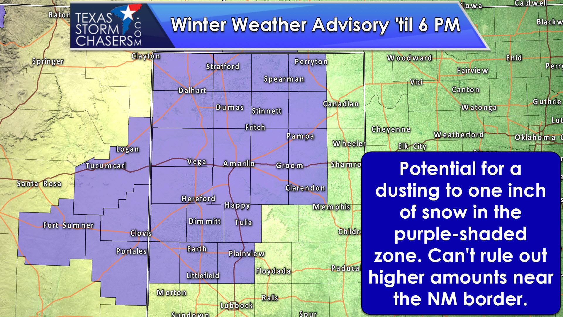
While temperature profiles will be marginal for winter weather, there is a chance of a rain/snow mix in parts of the Texas Panhandle and the northern sections of the South Plains through the late afternoon hours. The best chance for accumulating snowfall will be in the far southwest portions of the Texas Panhandle into adjacent sections of New Mexico. Otherwise there is the potential for a dusting to one-half inch of snow across the remainder of the Texas Panhandle. Recent warm weather and surface temperatures remaining near freezing should keep most roadways just wet, although slush could be a hazard if we see some heavier snow rates.
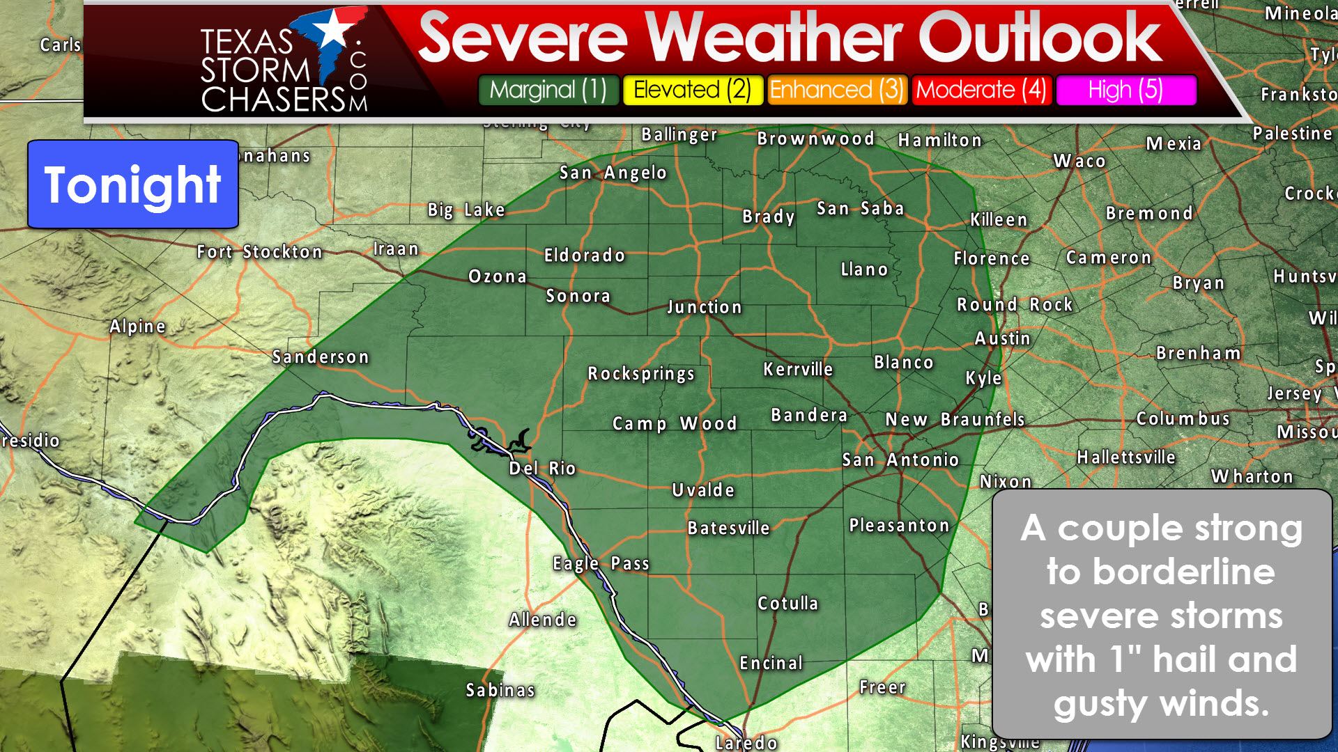
Cold temperatures aloft and a northward moving warm front will introduce the chance for stronger storms tonight in the Concho Valley, Southwest Texas, Hill Country, and parts of Central Texas. The primary threat with any stronger storms will be some small hail and localized strong wind gusts. A couple storms may briefly become borderline severe with hail up to the size of quarters and a wind gusts around 55 to 60 MPH. We’re not expecting widespread severe storms tonight, but they’ll certainly try their best to be loud.
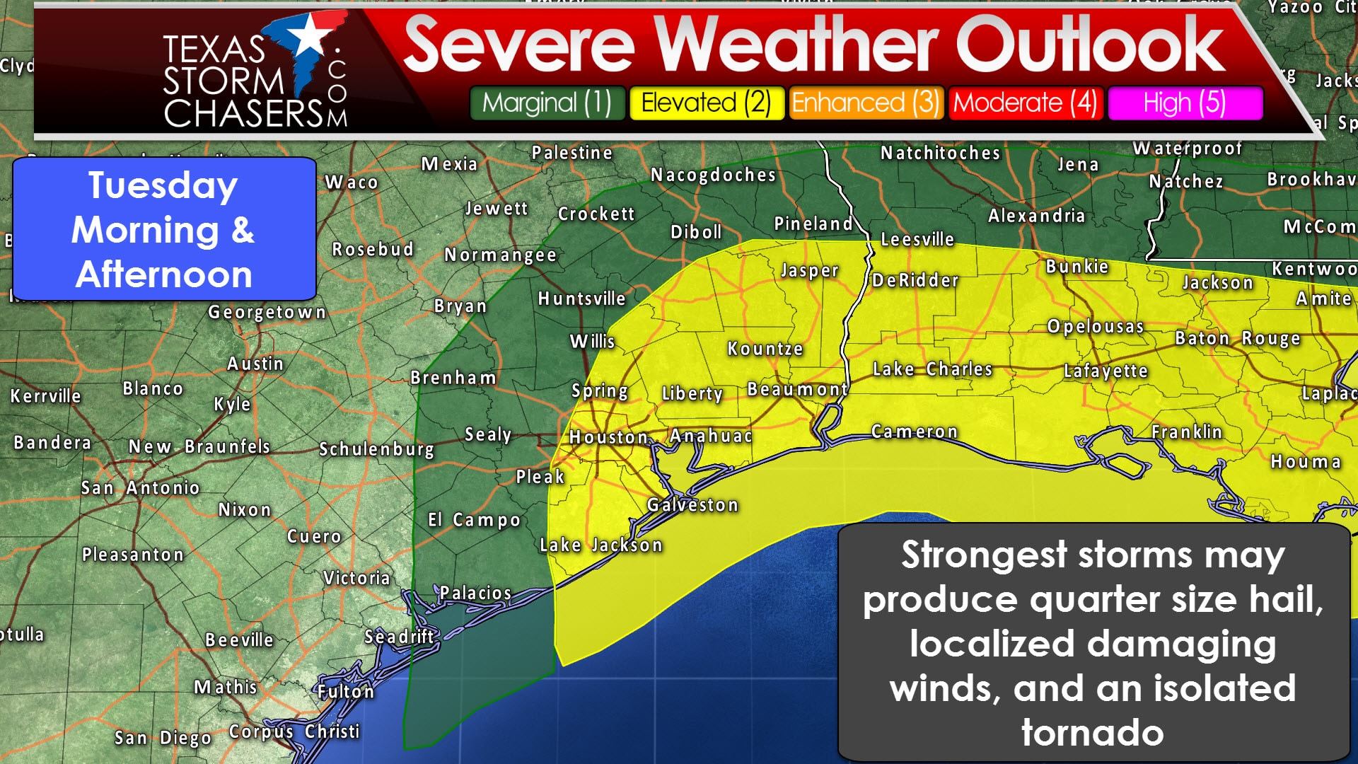
As the surface low pressure moves off to the east/northeast on Tuesday we could see a more unstable airmass move onshore in parts of Southeast Texas. The atmosphere will be supportive of a few severe storms capable of producing hail up to the size of half-dollars and localized wind gusts up to 65 MPH. If we see an unstable surface-based air mass advect inland we could also see a low-end tornado threat develop. At this time it looks like any tornado threat would likely be relegated to within 25-40 miles of the coast in far Southeast Texas. The chance for some stronger storms capable of producing small hail and gusty winds will extend up to Brenham-Crockett-Nacogdoches line. We’ll keep an eye on the data in case things start to look a bit more unsettled for Tuesday morning and afternoon.
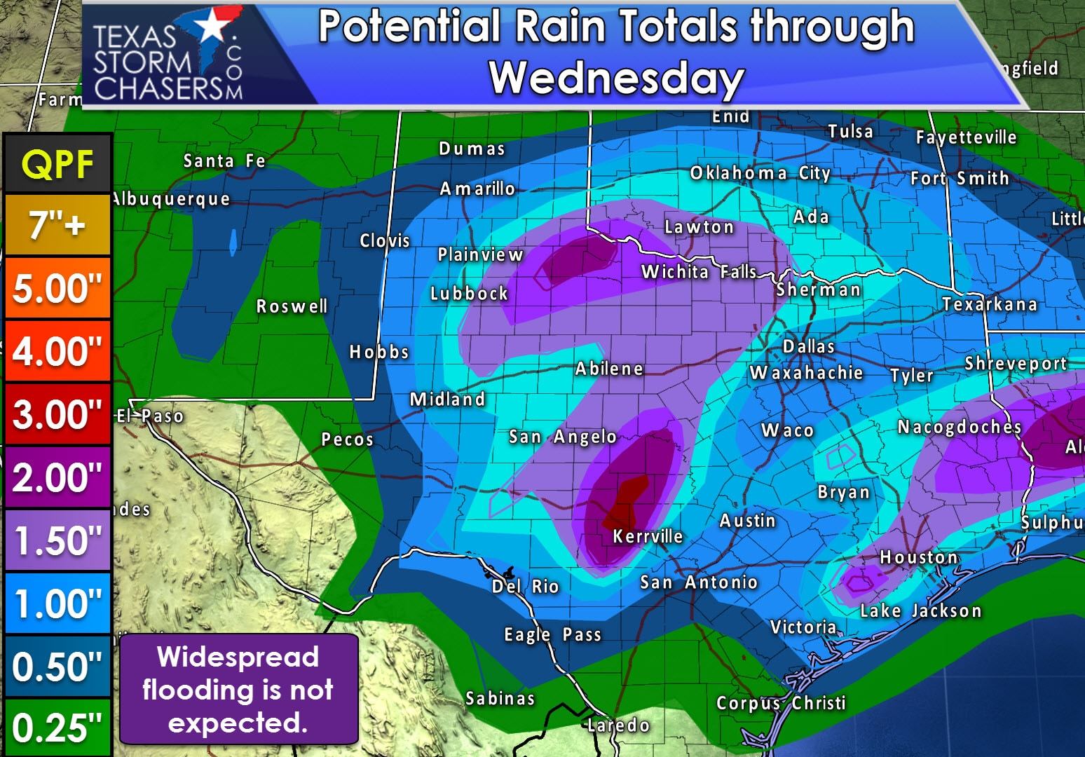
With plenty of moisture in place and a good storm system moving across the state through Tuesday we’re looking at a widespread soaking across Texas. Widespread rain amounts of one-half inch to two inches are possible from the southern Texas Panhandle and the Permain Basin all the way east into southwest Arkansas and Louisiana. Some folks will receive less and some folks could receive more. Widespread flooding is not anticipated at this time since we’ve had dry weather as of late and most activity will be moving at a decent pace. Localized, minor flooding could occur where heavier rains fall in a short period of time. Do be mindful of slick, oily roads as the rain starts since we have been dry. As mentioned above we’ll see all precipitation exit Texas by early Wednesday. Our next storm system looks to arrive in the Sunday timeframe with the potential for active weather.


0 Comments