

A complex and busy forecast is in store for the next week as several cold fronts interact with upper level storm systems. Buckle up and join us for the ride! Our first cool front will keep high temperatures in the 40s and 50s in the Texas Panhandle, Big Country, Northwest Texas, North Texas, and Northeast Texas today. South of that front temperatures will make it into the 60s and 70s. El Paso looks to top out around 72 degrees today, Houston at 67, and Brownsville right around 76F. Temperatures tonight will be chilly in the Panhandle and West Texas with upper teens to middle 20s expected. The freezing line should extend into West-Central Texas, the Big Country, into western North Texas.
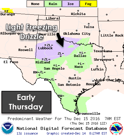
I mention the freezing line because we could have pockets of light rain or drizzle tonight. Where temperatures are below freezing that drizzle would become freezing drizzle. Warm ground temperatures and the overall light nature of the precipitation should prevent widespread icing issues where temperatures fall below freezing. I would not be surprised if a few bridges ice up in West Texas or the Big Country tonight. This should be a very low-end winter weather event, but we’ll have to keep an eye on bridges tonight. Drizzle will be possible in the Concho Valley extending through South Texas, and back up north through Central Texas and North Texas. Those locations will be above freezing, so just pesky drizzle for them!
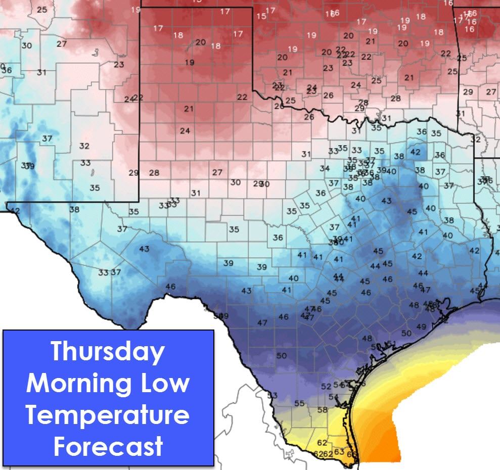
Thursday will tend to stay on the cooler side, but a big-time warmup is expected on Friday. High temperatures will range from the 60s in Northeast Texas up into the 80s across South Texas and the Permian Basin. The Panhandle, West Texas, Big Country, into Southeast Texas will all top out in the 70s with strong southerly/southwesterly winds. However, as many Texans who have lived here for a while know, it is often right after one of these big warm ups that a blue northern arrives. That will be the understatement of the week.
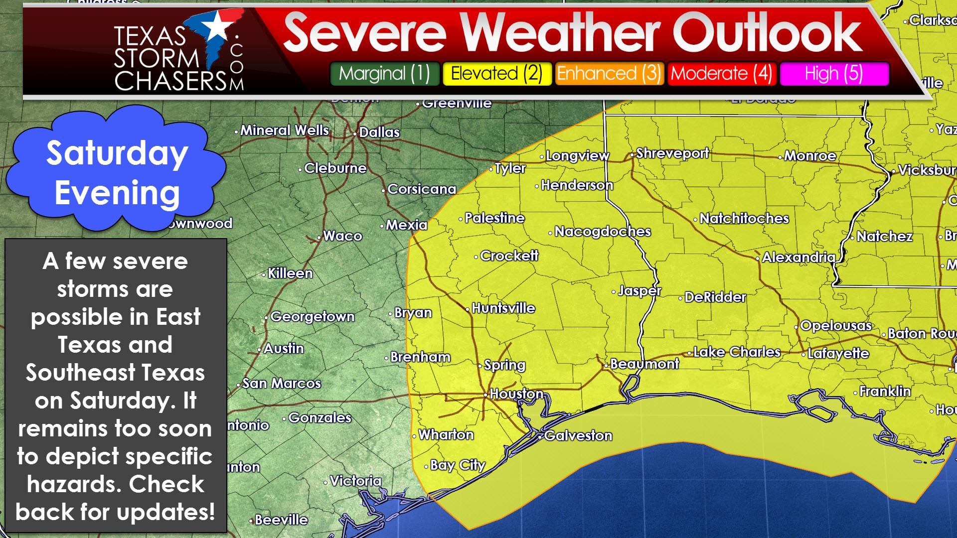
The folks at the Storm Prediction Center have highlighted a risk of severe storms on Saturday in East Texas, the Brazos Valley, and Southeast Texas. This risk currently runs along and east of a Tyler, College Station, to Wharton line. At this point it looks like a few storms may produce localized damaging wind gusts and isolated tornadoes. We’re still at the phase where specific severe weather ingredients can’t be accurately forecast due to the time-range. A strong cap could prevent most thunderstorm development during the day, so this could be a Saturday evening and Saturday night event. The forecast will probably need to be adjusted as future model data arrives.
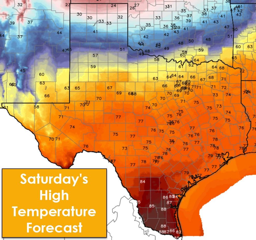
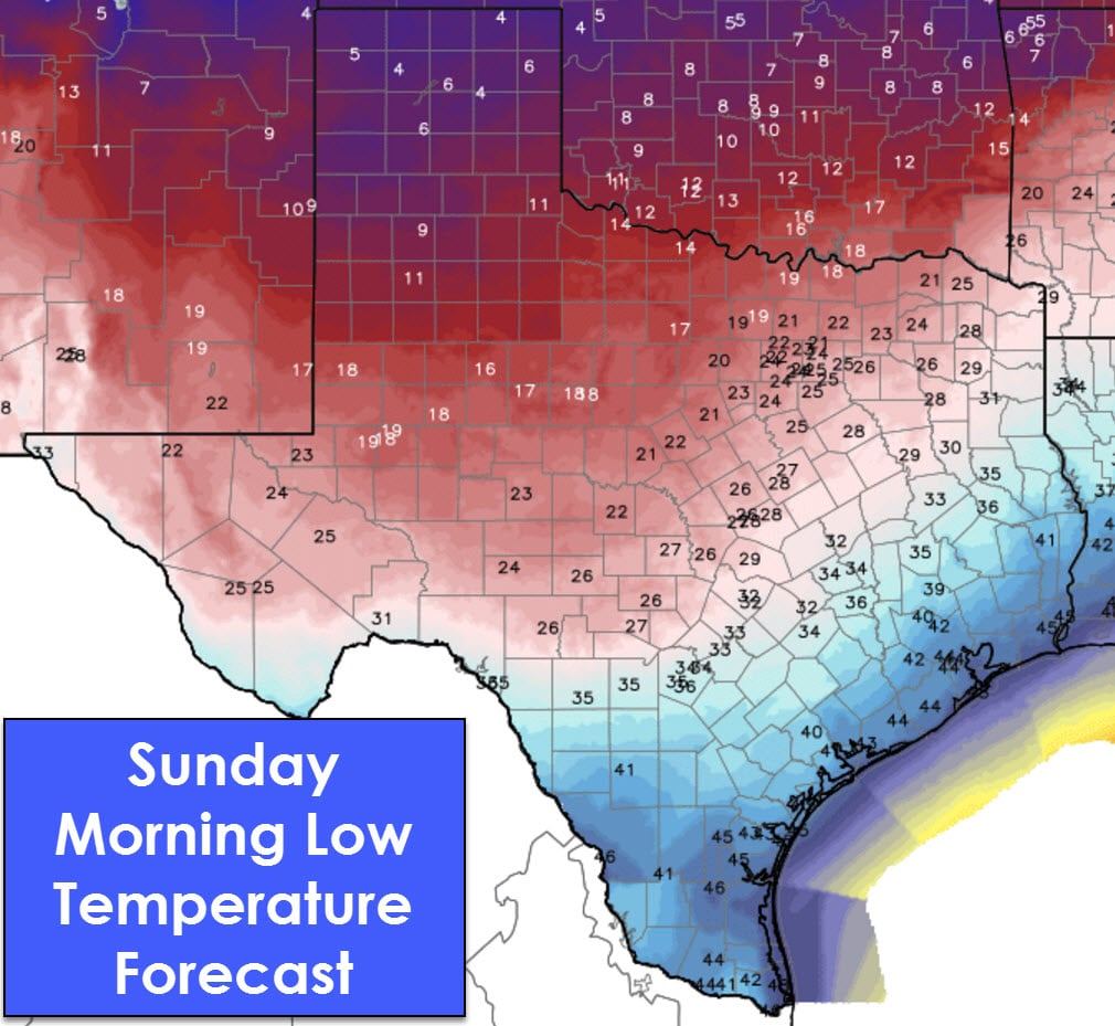
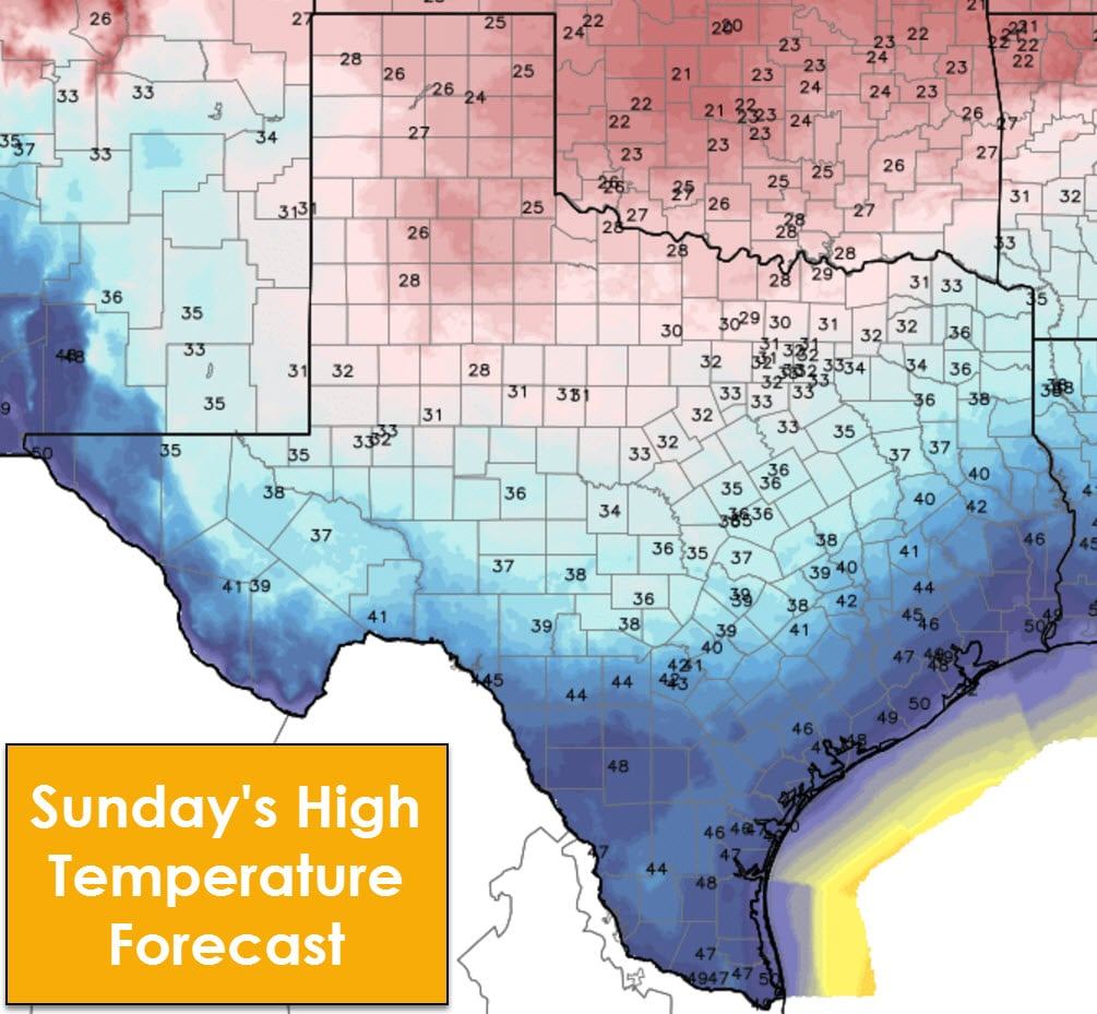
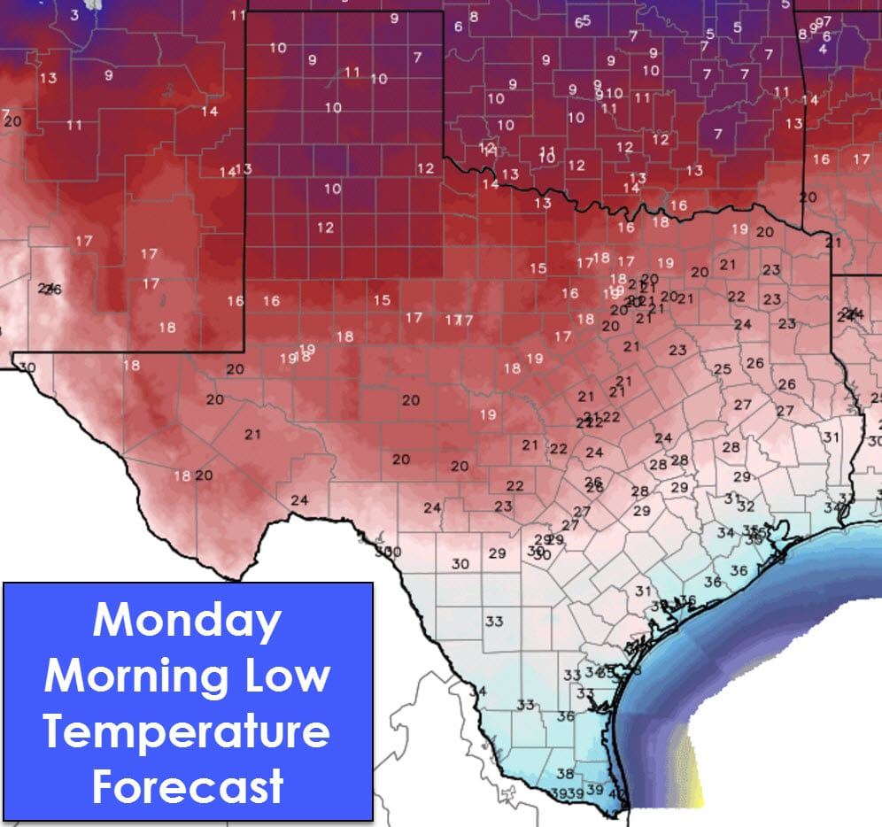
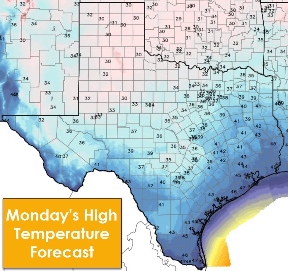
A very powerful arctic cold front will push from north to south on Saturday into Saturday Night across Texas. Temperatures south of the front will make it into the 60s, 70s, and 80s on Saturday. Depending on the front’s timing to your location the high temperature may occur during the morning hours. A drastic temperature drop is expected with the front’s passage with temperatures dropping 20 to 30 degrees in about an hour. North winds will be blasting up to 40 MPH and wind chills will not be pleasant. The result will be high temperatures on Sunday and Monday struggling to get out of the 20s, 30s, and 40s. Some locations will not get above freezing for several days, starting Saturday evening and continuing through Monday. Wind chill values during the morning hours Sunday may drop below zero where lows make it into the single digits and lower teens. Don’t think your wind chill will be much more pleasant if you’re further south. A blustery north wind will make things feel even colder, no matter what part of Texas you reside in. Buckle up folks, because this is going to be one nasty arctic blast.
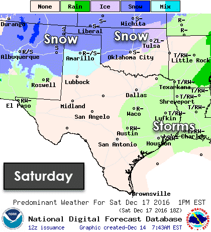
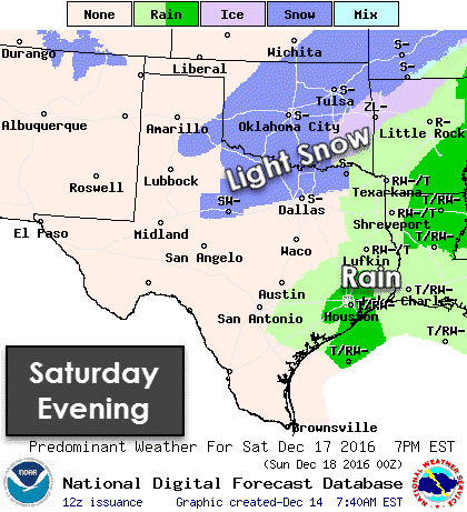
Now… lets discuss the possibility of snow on Saturday and Saturday Night. The powerful nature of the front, combined with some upper level lift associated with it, will probably allow pockets of light snow to develop on Saturday and Saturday Night. Right now it looks like parts of the Texas Panhandle, Northwest Texas, the Red River Valley east through Texoma, and parts of the Big Country and North Texas may be impacted. Some accumulation of snow is possible in the Texas Panhandle, while only light accumulations are expected in Northwest Texas, Texoma, and North Texas. A strong north wind, warm ground temperatures, and the light nature of the snow should prevent most accumulations. Still, a dusting or light coating of snow seems possible at this point. Somewhat higher accumulations may occur in the Texas Panhandle. All of this is subject to change and undoubtedly will need to be adjusted as we get closer to the weekend.


0 Comments